


Original file (1,595 × 2,000 pixels, file size: 1.87 MB, MIME type: image/jpeg)
Summary
| Description |
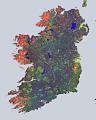
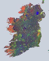
English: The Sentinel-1A satellite takes us over to Ireland, in this multi-temporal colour composite of land coverage across the island.
With a coastline of 7500 km, Ireland is home to some 4.8 million people and a wealth of history and tradition. Stretching 486 km from north to south and 275 km across, Ireland is washed by abundant rainfall all year, coating the country in omnipresent emerald-green grasslands. The coastal mountain fringes in the west, northwest and east are composed mainly of granite, while old red sandstone predominates in the south. Many lakes, large bog areas and low ridges make up the very scenic lowland, as seen throughout the image. This image was stitched together from 16 radar scans by the satellite during May 2015, and gives us an idea of the island’s land cover and use. Different colours show changes that occurred within the 12 days’ coverage. The blues across the entire image represent strong changes in bodies of water or agricultural activities such as ploughing. The yellows represent urban centres, with the capital city of Dublin very distinct on the far middle right. An interesting feature is the many yellow ‘spots’ scattered throughout the entire island, visible even more clearly when zooming in. These clusters all represent farmhouses. Vegetated fields and forests appear in green. The reds and oranges represent unchanging features such as bare soil or possibly rocks that border the forests, as is clear on the left side of the image, along the tips of the island. Sentinel-1A has been in orbit since 3 April 2014. It is a polar-orbiting, all-weather, day-and-night radar imaging mission for land and ocean services, monitoring the marine environment and mapping water and soil surfaces, among other major applications. Its sister, Sentinel-1B, is scheduled for launch on 22 April. This image is also featured on the Earth from Space video programme. |
| Date | |
| Source | http://www.esa.int/spaceinimages/Images/2016/04/Irish_mosaic |
| Author | European Space Agency |
| Permission (Reusing this file) |
Contains modified Copernicus Sentinel data [2015], processed by ESA,CC BY-SA 3.0 IGO |
| Other versions |
|
| Title | Irish mosaic |
| Set | Earth observation image of the week |
| System | Copernicus |
| Mission | Sentinel-1 |
| Location | Ireland |
| Activity | Observing the Earth |
| Keywords | Coast; Coast line; Islands; Lakes; Land use; Radar; Radar Images; Satellite image; Agriculture; Urban areas; Vegetation monitoring |
Licensing
- You are free:
- to share – to copy, distribute and transmit the work
- to remix – to adapt the work
- Under the following conditions:
- attribution – You must give appropriate credit, provide a link to the license, and indicate if changes were made. You may do so in any reasonable manner, but not in any way that suggests the licensor endorses you or your use.
- share alike – If you remix, transform, or build upon the material, you must distribute your contributions under the same or compatible license as the original.

|
This image contains data from a satellite in the Copernicus Programme, such as Sentinel-1, Sentinel-2 or Sentinel-3. Attribution is required when using this image.
Attribution: Contains modified Copernicus Sentinel data {{{year}}}
The use of Copernicus Sentinel Data is regulated under EU law (Commission Delegated Regulation (EU) No 1159/2013 and Regulation (EU) No 377/2014). Relevant excerpts:
Free access shall be given to GMES dedicated data [...] made available through GMES dissemination platforms [...].
Access to GMES dedicated data [...] shall be given for the purpose of the following use in so far as it is lawful:
GMES dedicated data [...] may be used worldwide without limitations in time.
GMES dedicated data and GMES service information are provided to users without any express or implied warranty, including as regards quality and suitability for any purpose. |
File history
Click on a date/time to view the file as it appeared at that time.
| Date/Time | Thumbnail | Dimensions | User | Comment | |
|---|---|---|---|---|---|
| current | 15:17, 7 May 2017 | | 1,595 × 2,000 (1.87 MB) | Fæ | European Space Agency, Id 358799, http://www.esa.int/spaceinimages/Images/2016/04/Irish_mosaic, User:Fæ/Project_list/ESA |
File usage
The following page uses this file:
You must be logged in to post a comment.