


Size of this preview: 800 × 554 pixels. Other resolutions: 320 × 222 pixels | 640 × 443 pixels | 1,024 × 709 pixels | 1,266 × 877 pixels.
Original file (1,266 × 877 pixels, file size: 66 KB, MIME type: image/jpeg)

|
This map image could be re-created using vector graphics as an SVG file. This has several advantages; see Commons:Media for cleanup for more information. If an SVG form of this image is available, please upload it and afterwards replace this template with
{{vector version available|new image name}}.
It is recommended to name the SVG file “Aratika Atoll - EVS Precision Map (1-115,000).svg”—then the template Vector version available (or Vva) does not need the new image name parameter. |
Summary
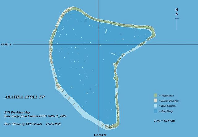
| Description | Aratika Atoll - EVS Precision Map (1:115,000) | ||
| Date | |||
| Source | originally posted to Flickr as Aratika Atoll - EVS Precision Map (1-115,000) | ||
| Author | Mr Minton | ||
| Permission (Reusing this file) |
|
Licensing
This file is licensed under the Creative Commons Attribution 2.0 Generic license.
- You are free:
- to share – to copy, distribute and transmit the work
- to remix – to adapt the work
- Under the following conditions:
- attribution – You must give appropriate credit, provide a link to the license, and indicate if changes were made. You may do so in any reasonable manner, but not in any way that suggests the licensor endorses you or your use.
File history
Click on a date/time to view the file as it appeared at that time.
| Date/Time | Thumbnail | Dimensions | User | Comment | |
|---|---|---|---|---|---|
| current | 16:48, 27 November 2008 | | 1,266 × 877 (66 KB) | Flickr upload bot | Uploaded from http://flickr.com/photo/60042877@N00/3053980313 using Flickr upload bot |
File usage
The following page uses this file:
Global file usage
The following other wikis use this file:
.jpg)
You must be logged in to post a comment.