


Crone Woods, also Crone Forest, is located in the northeastern section of the Wicklow Mountains, just below the summit of Maulin 570 metres (1,870 ft), in County Wicklow, Ireland.[1] Crone Woods have an extensive network of forest trails and hikes which can be accessed from the village of Enniskerry.[2]
Description
The woods were once part of the Powerscourt Estate with records from the 13th-century showing the area was set aside as a royal hunting ground.[1] Use of the woods for cover during the 1798 Rebellion led to the creation of the military road through northern Wicklow Mountains with several barracks to open up the region.[1] The forest is owned and operated by Coillte, the Irish state forestry agency.[1]
Trails in the wood include several to 'Ride Rock', from which there are views down into Powerscourt Waterfall. Other trails lead to the summit of Maulin.[2][3]
Crone Woods is an access point to the Wicklow Way, the oldest long-distance trail in the Republic of Ireland, which extends for 131 kilometres (81 mi) from its starting point in Marlay Park in South Dublin to Clonegal Village in County Carlow.[2] The wood is also used by hill-walkers completing the 16-kilometre loop of Maulin, Tonduff 642 metres (2,106 ft), War Hill 686 metres (2,251 ft) and Djouce 725 metres (2,379 ft), which is sometimes called the 'Circuit of Glensoulan'.[4]
Gallery
-
 Crone Wood trails
 -
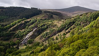 Powerscourt Waterfall and Crone Woods
 -
 Final path to Maulin from Crone Woods


See also
References
- ^ a b c d "Crone Woods". Coillte. Retrieved 11 July 2019.
- ^ a b c Christopher Sommerville (6 June 2009). "Walk of the week: Crone Woods and Maulin Mountain Co Wicklow". Irish Independent. Retrieved 10 July 2019.
- ^ Michael Guilfoyle (30 August 2017). "CRONE WOOD: Walk for the Weekend: A short, simple and safe trail". Irish Times. Retrieved 11 July 2019.
- ^ Michael Guilfoyle (11 November 2015). "A walk for the weekend: Circuit of Glensoulan, Co Wicklow". Irish Times. Retrieved 10 July 2019.
External links
- Crone Woods Map and Trails Coillte (July 2019)


You must be logged in to post a comment.