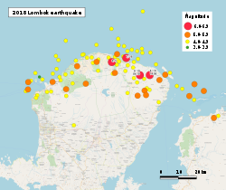
On 19 August 2018 a major earthquake struck with high intensity on the northeast corner of Lombok (Sambelia and Labuhan Lombok settlements) and northwest Sumbawa (Poto Tano settlement) at 22:56 local time, a few km to the east of a series of quakes that had been rocking the area for the past 3 weeks. It was measured at Mw 6.9 (USGS), at a depth of 21.0 km.[1] The Indonesian BMKG announced that it was a new major earthquake and not an aftershock. The earthquake occurred on the same overall structure, the Flores back-arc thrust fault. However, according to scientists, it happened on a different thrust fault as there are many individual structures within the belt.[2] There were 14 deaths and 1800 homes were damaged, around half of them severely, due to this event, including deaths on Sumbawa, following 2 deaths from the previous Lombok quake roughly 24 hours earlier.[3] Heavy tiles fell from the local mosque, and 143 patients were treated outdoors in makeshift tents for injuries on Sumbawa.[4]
See also
References
- ^ "M 6.9 – 2 km S of Belanting, Indonesia". United States Geological Survey. Retrieved 19 August 2018.
- ^ "BMKG: Gempa 7,0 SR di Lombok Aktivitas Baru, Beda dengan Sebelumnya". Detik news (in Indonesian). Retrieved 20 August 2018.
- ^ "Quake swarm jolts Indonesian islands, killing at least 13". Bangkok Post. Retrieved 20 August 2018.
- ^ Santoso, Audrey. "Gempa Lombok, 143 Pasien Dirawat di Lapangan Kantor Pemda Sumbawa". Detik news (in Indonesian). Retrieved 20 August 2018.
External links
- The International Seismological Centre has a bibliography and/or authoritative data for this event.
- ReliefWeb's main page for this event. – This link covers all the July and August Lombok earthquakes.


You must be logged in to post a comment.