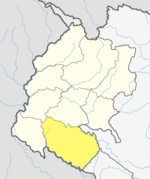
Tikapur (Nepali: टिकापुर) is a Municipality in Kailali District in Sudurpashchim Province of Nepal that was established in January 1997. Tikapur Municipality was further expanded on 10 March 2017 through merger with the two former Village development committees Narayanpur and Dansinhapur.[1] It lies on the bank of Karnali River.
Demographics
At the time of the 2011 Nepal census, Tikapur Municipality had a population of 76,940. Of these, 41.2% spoke Tharu, 36.3% Nepali, 16.4% Achhami, 1.6% Doteli, 1.5% Magar, 0.7% Hindi, 0.6% Bhojpuri, 0.5% Maithili, 0.2% Dadeldhuri, 0.2% Dailekhi, 0.2% Newar, 0.1% Jumli, 0.1% Raji, 0.1% Tamang, 0.1% Thakali, 0.1% Urdu and 0.1% other languages as their first language.[2]
In terms of ethnicity/caste, 41.8% were Tharu, 22.6% Chhetri, 10.5% Hill Brahmin, 7.8% Kami, 4.2% Thakuri, 3.4% other Dalit, 3.1% Magar, 2.1% Damai/Dholi, 0.6% Sanyasi/Dasnami, 0.5% Lohar, 0.5% Musalman, 0.4% Mallaha, 0.4% Newar, 0.4% Sarki, 0.3% Badi, 0.2% Kurmi, 0.1% Gurung, 0.1% Kathabaniyan, 0.1% Kumal, 0.1% Meche, 0.1% Rai, 0.1% Rajbanshi, 0.1% Raji, 0.1% Tamang, 0.1% other Terai, 0.1% Thakali, 0.1% Thami and 0.1% others.[3]
In terms of religion, 94.6% were Hindu, 4.0% Christian, 0.8% Buddhist, 0.5% Muslim and 0.1% others.[4]
In terms of literacy, 67.1% could read and write, 2.3% could only read and 30.6% could neither read nor write.[5]
Tikapur is 3rd largest city in Sudurpashchim Province after Dhangadhi and Bhimdutta (formerly Mahendranagar).
Transportation
Tikapur Airport is an out-of-service airport that lies in Tikapur.[6]
Gallery
-
Gray Langur, Tikapur Park, Kailali
Mayoral Election
| Party | Candidate | Votes | Status |
|---|---|---|---|
| People's Freedom Part (नागरीक उन्मुक्ती पार्टी) | Ram Lal Dagaura Tharu (रामलाल डगौरा थारु) | 9642 | Elected |
Deputy Mayor Election
| Party | Candidate | Votes | Status |
|---|---|---|---|
| CPN Maoist | Khadak Bahadur Shah (खडक बहादुर शाह) | 7955 | Elected |
Climate
| Climate data for Tikapur, elevation 149 m (489 ft), (1991–2020 normals) | |||||||||||||
|---|---|---|---|---|---|---|---|---|---|---|---|---|---|
| Month | Jan | Feb | Mar | Apr | May | Jun | Jul | Aug | Sep | Oct | Nov | Dec | Year |
| Mean daily maximum °C (°F) | 20.1 (68.2) |
25.2 (77.4) |
30.4 (86.7) |
36.4 (97.5) |
37.6 (99.7) |
36.5 (97.7) |
33.7 (92.7) |
32.6 (90.7) |
32.7 (90.9) |
31.7 (89.1) |
28.2 (82.8) |
22.8 (73.0) |
30.7 (87.2) |
| Daily mean °C (°F) | 13.6 (56.5) |
17.4 (63.3) |
21.7 (71.1) |
27.2 (81.0) |
30.0 (86.0) |
30.9 (87.6) |
29.6 (85.3) |
28.9 (84.0) |
28.4 (83.1) |
25.3 (77.5) |
20.6 (69.1) |
15.4 (59.7) |
24.1 (75.4) |
| Mean daily minimum °C (°F) | 7.1 (44.8) |
9.5 (49.1) |
12.9 (55.2) |
17.9 (64.2) |
22.4 (72.3) |
25.3 (77.5) |
25.5 (77.9) |
25.1 (77.2) |
24.1 (75.4) |
18.8 (65.8) |
13.0 (55.4) |
7.9 (46.2) |
17.5 (63.4) |
| Average precipitation mm (inches) | 33.6 (1.32) |
29.0 (1.14) |
19.0 (0.75) |
16.7 (0.66) |
76.5 (3.01) |
227.9 (8.97) |
499.7 (19.67) |
460.0 (18.11) |
268.8 (10.58) |
47.8 (1.88) |
3.6 (0.14) |
15.6 (0.61) |
1,698.1 (66.85) |
| Source 1: Department of Hydrology and Meteorology[8] | |||||||||||||
| Source 2: JICA (precipitation)[9] | |||||||||||||
References
- ^ "Brief Introduction". Tikapur Municipality. Retrieved 1 May 2018.
- ^ NepalMap Language
- ^ NepalMap Caste
- ^ NepalMap Religion
- ^ NepalMap Literacy
- ^ "Tikapur Airport" (PDF). Civil Aviation authority of Nepal. Retrieved 1 May 2018.
- ^ "मतगणना प्रगतिको विवरण".
- ^ "Climate Division (Climate Analysis Section)". Department of Hydrology and Meteorology. Retrieved 8 February 2025.
- ^ "ネパール国 全国貯水式水力発電所マスタープラン調査 ファイナルレポート" (PDF). Japan International Cooperation Agency. Archived from the original (PDF) on 6 April 2024. Retrieved 21 February 2025.


