m revert to last version by 63.97.17.242 |
151.166.15.124 (talk) No edit summary |
||
| Line 1: | Line 1: | ||
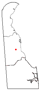
'''Dover Air Force Base''' ('''Dover AFB''') is a [[military base|base]] of the [[United States Air Force]] in the state of [[Delaware]]. The base is located two miles south of the city of [[Dover, Delaware|Dover]] — the capital of Delaware. |
'''Dover Air Force Base''' ('''Dover AFB''') is a [[military base|base]] of the [[United States Air Force]] in the state of [[Delaware]]. The base is located two miles south of the city of [[Dover, Delaware|Dover]] — the capital of Delaware. |
||
Dover AFB is home to the [[436th Airlift Wing]], known as the "Eagle Wing", and the [[512th Airlift Wing]], referred to as the "Liberty Wing". It is the home base for the largest military mortuary in the [[United States Department of Defense|Department of Defense]], and has been used for processing military personnel killed in both war and peacetime. The mortuary was used in 1986 for identifying the remains of the crew of the [[Space Shuttle Challenger|Space Shuttle ''Challenger'']], and in 2003 for the crew of the [[Space Shuttle Columbia|Space ''Shuttle Columbia'']]. |
Dover AFB is home to the [[436th Airlift Wing]], known as the "Eagle Wing", and the [[512th Airlift Wing]], referred to as the "Liberty Wing". It is the home base for the largest military mortuary in the [[United States Department of Defense|Department of Defense]], and has been used for processing military personnel killed in both war and peacetime. The mortuary was used in 1986 for identifying the remains of the crew of the [[Space Shuttle Challenger|Space Shuttle ''Challenger'']], and in 2003 for the crew of the [[Space Shuttle Columbia|Space ''Shuttle Columbia'']]. It also was a major site for identifying the remains of military personle killed in the 9/11 attacks |
||
The base is treated as a [[census-designated place]] called "Dover Base Housing." As of the 2000 census, the base had a total population of 3,394. Since 1997, the base has been served by three highway exits (one inactive) with [[Delaware Route 1]], allowing quick access to Dover or Southern Delaware from the complex. |
The base is treated as a [[census-designated place]] called "Dover Base Housing." As of the 2000 census, the base had a total population of 3,394. Since 1997, the base has been served by three highway exits (one inactive) with [[Delaware Route 1]], allowing quick access to Dover or Southern Delaware from the complex. |
||
Revision as of 21:13, 3 April 2006
Dover Air Force Base (Dover AFB) is a base of the United States Air Force in the state of Delaware. The base is located two miles south of the city of Dover — the capital of Delaware.
Dover AFB is home to the 436th Airlift Wing, known as the "Eagle Wing", and the 512th Airlift Wing, referred to as the "Liberty Wing". It is the home base for the largest military mortuary in the Department of Defense, and has been used for processing military personnel killed in both war and peacetime. The mortuary was used in 1986 for identifying the remains of the crew of the Space Shuttle Challenger, and in 2003 for the crew of the Space Shuttle Columbia. It also was a major site for identifying the remains of military personle killed in the 9/11 attacks
The base is treated as a census-designated place called "Dover Base Housing." As of the 2000 census, the base had a total population of 3,394. Since 1997, the base has been served by three highway exits (one inactive) with Delaware Route 1, allowing quick access to Dover or Southern Delaware from the complex.
Geography

Dover Air Force Base is located at 39°7'6" North, 75°28'56" West (39.118388, -75.482272)Template:GR.
According to the United States Census Bureau, the base has a total area of 1.7 km² (0.7 mi²). 1.7 km² (0.7 mi²) of it is land and none of it is covered by water.
Demographics
As of the censusTemplate:GR of 2000, there were 3,394 people, 1,032 households, and 1,017 families residing in the base. The population density was 1,955.9/km² (5,061.6/mi²). There were 1,245 housing units at an average density of 717.5/km² (1,856.7/mi²). The racial makeup of the base was 72.57% White, 16.59% African American, 0.77% Native American, 1.86% Asian, 0.12% Pacific Islander, 2.80% from other races, and 5.30% from two or more races. 7.75% of the population were Hispanic or Latino of any race.
There were 1,032 households out of which 76.1% had children under the age of 18 living with them, 90.2% were married couples living together, 5.4% had a female householder with no husband present, and 1.4% were non-families. 1.2% of all households were made up of individuals and 0.2% had someone living alone who was 65 years of age or older. The average household size was 3.29 and the average family size was 3.30.
In the base the population was spread out with 40.2% under the age of 18, 16.5% from 18 to 24, 41.5% from 25 to 44, 1.7% from 45 to 64, and 0.1% who were 65 years of age or older. The median age was 23 years. For every 100 females there were 103.0 males. For every 100 females age 18 and over, there were 97.5 males.
The median income for a household in the base was $34,318, and the median income for a family was $34,659. Males had a median income of $26,322 versus $20,444 for females. The per capita income for the base was $12,119. 4.2% of the population and 5.2% of families were below the poverty line. 3.5% of those under the age of 18 and 0.0% of those 65 and older were living below the poverty line.
Hello my name is Napolean Dynamite. Can u give me some tots. i think your very sweet go make yourself tyour own casadilla.
External links
- GlobalSecurity.org: Dover AFB
- Dover AFB Home Page - official site.


