


Size of this PNG preview of this SVG file: 746 × 569 pixels. Other resolutions: 315 × 240 pixels | 629 × 480 pixels | 1,007 × 768 pixels | 1,280 × 976 pixels | 2,560 × 1,953 pixels.
Original file (SVG file, nominally 746 × 569 pixels, file size: 208 KB)
Summary
| Description |
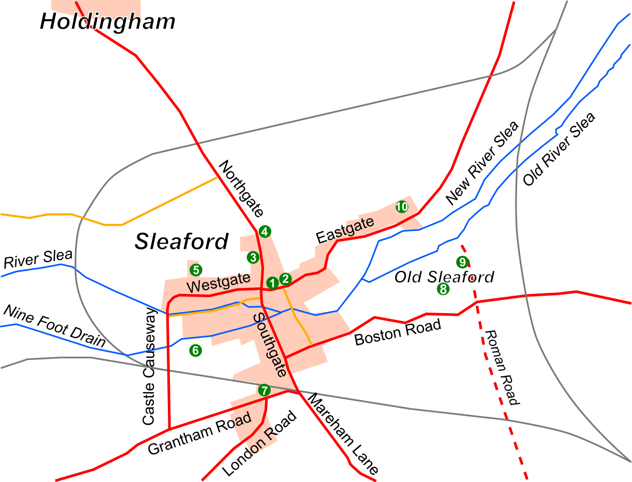
English: A map of Sleaford, Lincolnshire, as it was in 1891, showing the main roads (solid red), lesser roads (solid yellow-orange), built-up area (pink), rivers (solid blue), railways (solid grey), historic roads (dashed red) and sites of interest (green circles, numbered). The map is derived from the 1891 Ordnance Survey (1:10,560) map of the area. Key: (1) Market Place, (2) St Denys' Church, (3) Manor House, (4) Carre's Grammar School, (5) Westholme House, (6) Castle, (7) Station, (8) Old Place, (9) the remains of St Giles's Church, and (10) the Union workhouse. |
| Date | |
| Source |
Created by me in Inkscape, based on the 1891 Ordnance Survey map of the town: [1] and [2]. |
| Author | Noswall59 |
Licensing
I, the copyright holder of this work, hereby publish it under the following licenses:

|
Permission is granted to copy, distribute and/or modify this document under the terms of the GNU Free Documentation License, Version 1.2 or any later version published by the Free Software Foundation; with no Invariant Sections, no Front-Cover Texts, and no Back-Cover Texts. A copy of the license is included in the section entitled GNU Free Documentation License. |
This file is licensed under the Creative Commons Attribution-Share Alike 3.0 Unported license.
- You are free:
- to share – to copy, distribute and transmit the work
- to remix – to adapt the work
- Under the following conditions:
- attribution – You must give appropriate credit, provide a link to the license, and indicate if changes were made. You may do so in any reasonable manner, but not in any way that suggests the licensor endorses you or your use.
- share alike – If you remix, transform, or build upon the material, you must distribute your contributions under the same or compatible license as the original.
You may select the license of your choice.
File history
Click on a date/time to view the file as it appeared at that time.
| Date/Time | Thumbnail | Dimensions | User | Comment | |
|---|---|---|---|---|---|
| current | 12:32, 17 September 2014 | | 746 × 569 (208 KB) | Noswall59 | Updated numbers. |
| 12:23, 17 September 2014 |  | 746 × 569 (207 KB) | Noswall59 | {{subst:Upload marker added by en.wp UW}} {{Information |Description = {{en|A map of Sleaford, Lincolnshire, as it was in 1891, showing the main roads (solid red), lesser roads (solid yellow-orange), built-up area (pink), rivers (solid blue), railways... |
File usage
The following page uses this file:
Global file usage
The following other wikis use this file:
- Usage on azb.wikipedia.org