


No higher resolution available.
GWI_DU_map.gif (250 × 277 pixels, file size: 31 KB, MIME type: image/gif)

|
File:GWI DU map.svg is a vector version of this file. It should be used in place of this GIF file when not inferior.
File:GWI DU map.gif → File:GWI DU map.svg
For more information, see Help:SVG. |
 |

|
This map has been uploaded by Electionworld from en.wikipedia.org to enable the |
Summary
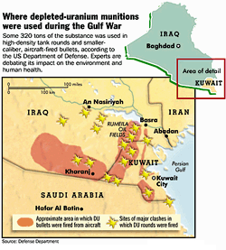
This map was released by the Office of the Special Assistant for Gulf War Illnesses (Bernard Rostker, Under Secretary of the Army) to the Presidential Special Oversight Board (former Senator Warren Rudman) on November 19, 1998 in Washington, DC.
Derivative works of this file: GWI DU map.svg
Licensing
This work is in the public domain in the United States because it is a work prepared by an officer or employee of the United States Government as part of that person’s official duties under the terms of Title 17, Chapter 1, Section 105 of the US Code.
Note: This only applies to original works of the Federal Government and not to the work of any individual U.S. state, territory, commonwealth, county, municipality, or any other subdivision. This template also does not apply to postage stamp designs published by the United States Postal Service since 1978. (See § 313.6(C)(1) of Compendium of U.S. Copyright Office Practices). It also does not apply to certain US coins; see The US Mint Terms of Use.
|
 | |
| This file has been identified as being free of known restrictions under copyright law, including all related and neighboring rights. | ||
File history
Click on a date/time to view the file as it appeared at that time.
| Date/Time | Thumbnail | Dimensions | User | Comment | |
|---|---|---|---|---|---|
| current | 17:07, 18 December 2006 | | 250 × 277 (31 KB) | Electionworld | {{ew|en|Stan Ison}} == Summary == This map was released by the Office of the Special Assistant for Gulf War Illnesses (Bernard Rostker, Under Secretary of the Army) to the Presidential Special Oversight Board (former Senator Warren Rudman) on November 19, |
File usage
The following 5 pages use this file:
Global file usage
The following other wikis use this file:
- Usage on ar.wikipedia.org
- Usage on cs.wikipedia.org
- Usage on en.wikiquote.org
- Usage on fa.wikipedia.org
- Usage on fi.wikipedia.org
- Usage on fr.wikipedia.org
- Usage on gu.wikipedia.org
- Usage on hi.wikipedia.org
- Usage on it.wikipedia.org
- Usage on kn.wikipedia.org
- Usage on pnb.wikipedia.org
- Usage on ru.wikipedia.org
- Usage on th.wikipedia.org
- Usage on tr.wikipedia.org
- Usage on uk.wikipedia.org
- Usage on ur.wikipedia.org
- Usage on zh.wikipedia.org