


Beit Lid (Arabic: بيت ليد) is a Palestinian town in the Tulkarm Governorate in the northeastern West Bank, located 10 kilometers southeast of Tulkarm and west of Nablus. According to the Palestinian Central Bureau of Statistics, the town had a population of 5,606 inhabitants in 2017.[1] In 1922, it had 653 inhabitants,[3] which rose to 1,807 in 1961.[4]
History
Byzantine ceramics have been found here.[5]The village mosque, entered through a large gate with a triple arch, contains an inscription over the lintel dating its construction to the late Mamluk or early Ottoman period.[6]
Ottoman era
Beit Lid, like all of Palestine was incorporated into the Ottoman Empire in 1517. In the 1596 tax registers, it was part of the nahiya ("subdistrict") of Jabal Sami, part of the larger Sanjak of Nablus. It had a population of 64 households, all Muslims. The inhabitants paid a fixed tax rate of 33,3% on agricultural products, including wheat, barley, summer crops, olive trees, goats and beehives, in addition to occasional revenues and a press for olive oil or grape syrup; a total of 17,310 akçe. Half of the revenues went to a Waqf.[7]
In 1838, Edward Robinson wrote that it was a village in the 'Wady esh-Sha'ir' administrative region, west of Nablus.[8] In 1863 Victor Guérin described it as a crudely constructed hilltop village with a population of 1000. [9]
In the 1860s, the Ottoman authorities granted the village an agricultural plot of land in the Forest of Arsur (Ar. Al-Ghaba) on the coastal plain west of the village. Ghabat Beit Lid became the nucleus of Khirbat Bayt Lid.[10][11]
In 1870/1871 (1288 AH), an Ottoman census listed the village in the nahiya (sub-district) of Wadi al-Sha'ir.[12]
In 1882, the PEF's Survey of Western Palestine (SWP) described Beit Lid as a small village on a hill rising 600 feet above the valley south of it. The houses were built of stone with a well on the southeast. [13]
British Mandate era
In the 1922 census of Palestine conducted by the British Mandate authorities, Beit Lid's population was 653, all Muslims,[3] increasing in the 1931 census to 738 residents living in 171 houses.[14]
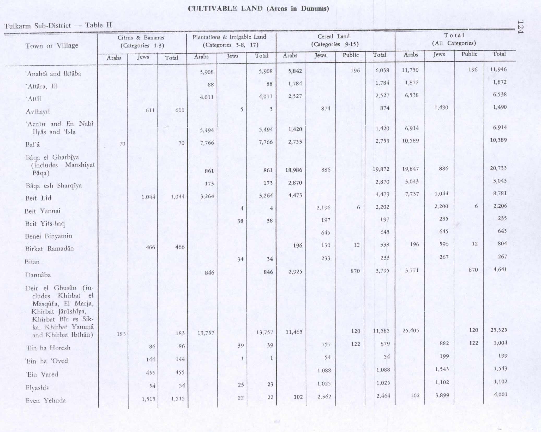
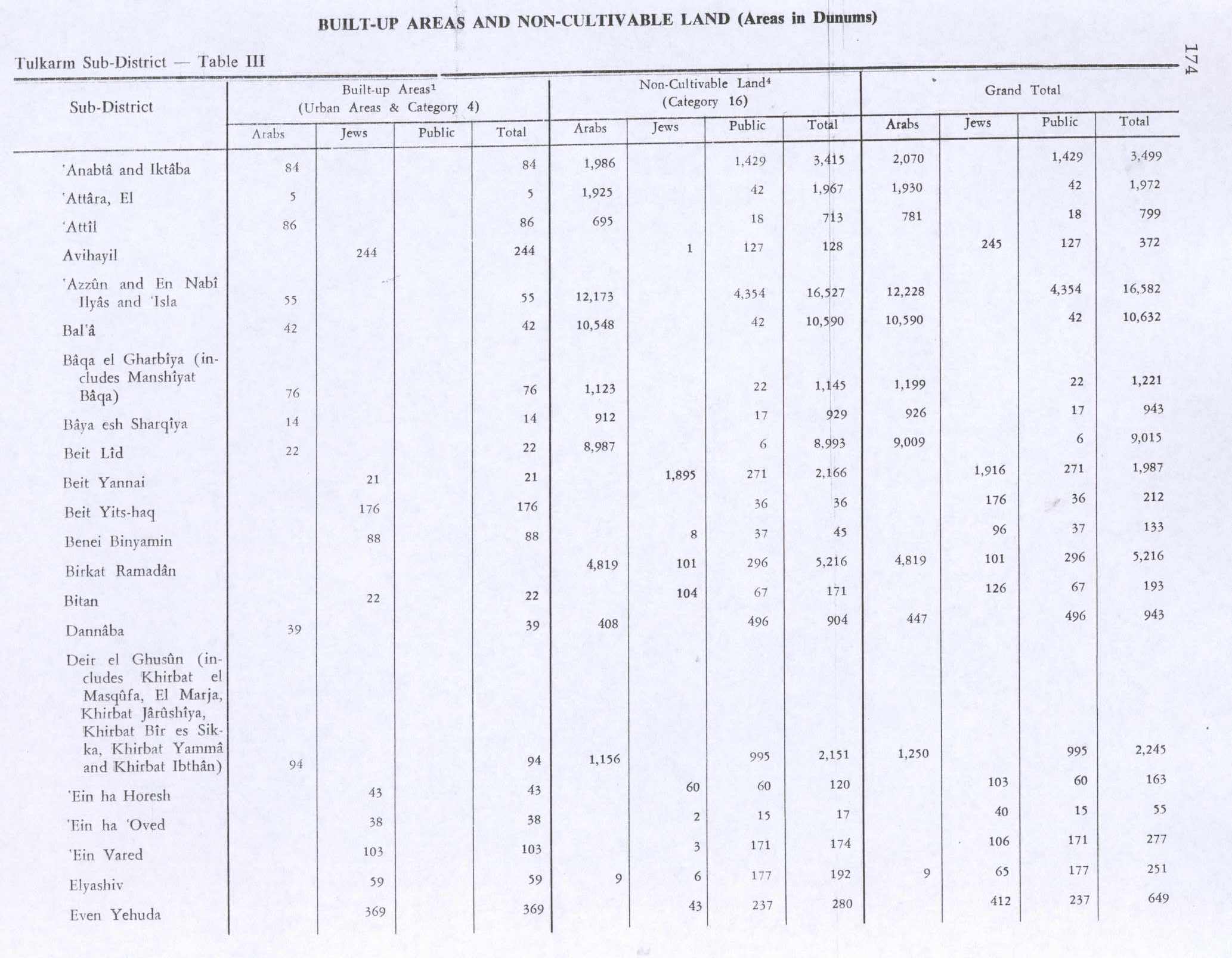
In the 1945 statistics the population of Beit Lid was 960 Muslims,[15] and the land area was 16,752 dunams, according to an official land and population survey.[16] 1,044 dunams were for citrus and bananas, 3,264 dunams were plantations and irrigable land, 4,473 used for cereals,[17] while 22 dunams were built-up (urban) land.[18]
1948-1967
In the wake of the 1948 Arab–Israeli War, and after the 1949 Armistice Agreements, Beit Lid came under Jordanian occupation.
In 1961, the population of Beit Lid was 1,807.[4]
Post-1967
After the Six-Day War in 1967, Beit Lid came under Israeli occupation.
Agriculture was a major economic sector in Beit Lid, with olives, almonds, figs, grapes and grains being the primary crops grown on 16,753 dunams. Many residents now work in construction, blacksmithing and electricity although employment in Israel dropped during the Second Intifada.[19]
In 2001, there were four schools (two primary and two secondary), four kindergartens and a clinic operated by the Palestinian National Authority. Beit Lid's four mosques are Masjid al-Qadim, Masjid Fatima Zahra, Masjid as-Salaam and Masjid Salah ad-Din.[19]
An Israeli military base near Beit Lid serves as the headquarters of Israel's military courts and military police. In July 2024, right-wing protesters demonstrated there after nine Israeli soldiers were detained at Sde Teiman detention camp for suspected torture and sexual abuse of Palestinian prisoners.[20]
See also
- Beit Lid suicide bombing (January 1995)
References
- ^ a b Preliminary Results of the Population, Housing and Establishments Census, 2017 (PDF). Palestinian Central Bureau of Statistics (PCBS) (Report). State of Palestine. February 2018. pp. 64–82. Retrieved 2023-10-24.
- ^ Palmer, 1881, p. 180
- ^ a b Barron, 1923, Table IX, Sub-district of Tulkarem, p. 27
- ^ a b Government of Jordan, 1964, p. 27
- ^ Dauphin, 1998, p. 768
- ^ Sharon, 1999, pp. 152 -153
- ^ Hütteroth and Abdulfattah, 1977, p. 126
- ^ Robinson and Smith, 1841, vol. 3, p. 137
- ^ Guérin, 1875, pp. 211 -212
- ^ Marom, Roy, "The Contribution of Conder's Tent Work in Palestine for the Understanding of Shifting Geographical, Social and Legal Realities in the Sharon during the Late Ottoman Period", in Gurevich D. and Kidron, A. (eds.), Exploring the Holy Land: 150 Years of the Palestine Exploration Fund, Sheffield, UK, Equinox (2019), pp. 212-231
- ^ Marom, Roy (2022). "The Oak Forest of the Sharon (al-Ghaba) in the Ottoman Period: New Insights from Historical- Geographical Studies, Muse 5,". escholarship.org. Retrieved 2023-10-06.
- ^ Grossman, David (2004). Arab Demography and Early Jewish Settlement in Palestine. Jerusalem: Magnes Press. p. 253.
- ^ Conder and Kitchener, 1882, SWP II, p. 159
- ^ Mills, 1932, p. 53
- ^ Government of Palestine, Department of Statistics, 1945, p. 20
- ^ Government of Palestine, Department of Statistics. Village Statistics, April, 1945. Quoted in Hadawi, 1970, p. 74
- ^ Government of Palestine, Department of Statistics. Village Statistics, April, 1945. Quoted in Hadawi, 1970, p. 124
- ^ Government of Palestine, Department of Statistics. Village Statistics, April, 1945. Quoted in Hadawi, 1970, p. 174
- ^ a b Information of Beit Lid PalestineRemembered. 2001-03-21. (in Arabic)
- ^ Peleg, Bar; Solomon, Eden; Maanit, Chen; Kubovich, Yaniv (30 July 2024). "IDF Moves Troops to Base Where Violent Mob Protested Arrest of Soldiers for Abusing Gaza Detainee". Haaretz. Archived from the original on 30 July 2024. Retrieved 30 July 2024.
Bibliography
- Barron, J.B., ed. (1923). Palestine: Report and General Abstracts of the Census of 1922. Government of Palestine.
- Conder, C.R.; Kitchener, H.H. (1882). The Survey of Western Palestine: Memoirs of the Topography, Orography, Hydrography, and Archaeology. Vol. 2. London: Committee of the Palestine Exploration Fund.
- Dauphin, C. (1998). La Palestine byzantine, Peuplement et Populations. BAR International Series 726 (in French). Vol. III : Catalogue. Oxford: Archeopress. ISBN 0-860549-05-4.
- Government of Jordan, Department of Statistics (1964). First Census of Population and Housing. Volume I: Final Tables; General Characteristics of the Population (PDF).
- Government of Palestine, Department of Statistics (1945). Village Statistics, April, 1945.
- Guérin, V. (1875). Description Géographique Historique et Archéologique de la Palestine (in French). Vol. 2: Samarie, pt. 2. Paris: L'Imprimerie Nationale.
- Hadawi, S. (1970). Village Statistics of 1945: A Classification of Land and Area ownership in Palestine. Palestine Liberation Organization Research Center.
- Hütteroth, W.-D.; Abdulfattah, K. (1977). Historical Geography of Palestine, Transjordan and Southern Syria in the Late 16th Century. Erlanger Geographische Arbeiten, Sonderband 5. Erlangen, Germany: Vorstand der Fränkischen Geographischen Gesellschaft. ISBN 3-920405-41-2.
- Mills, E., ed. (1932). Census of Palestine 1931. Population of Villages, Towns and Administrative Areas. Jerusalem: Government of Palestine.
- Palmer, E.H. (1881). The Survey of Western Palestine: Arabic and English Name Lists Collected During the Survey by Lieutenants Conder and Kitchener, R. E. Transliterated and Explained by E.H. Palmer. Committee of the Palestine Exploration Fund.
- Robinson, E.; Smith, E. (1841). Biblical Researches in Palestine, Mount Sinai and Arabia Petraea: A Journal of Travels in the year 1838. Vol. 3. Boston: Crocker & Brewster.
- Sharon, M. (1999). Corpus Inscriptionum Arabicarum Palaestinae, B-C. Vol. 2. BRILL. ISBN 90-04-11083-6.
External links
- Welcome To Bayt Lid
- Beit Lid, Welcome to Palestine
- Survey of Western Palestine, Map 11: IAA, Wikimedia commons

| Authority control databases: National |
|---|