


Holosiivskyi District[a] is an urban district of the city of Kyiv, the capital of Ukraine.
Holosiivskyi District was created during changing of administrative divisions of the capital of Ukraine, which was conducted in September 2001, as per the decision of the Kyiv City Council on January 1, 2001.
Holosiivskyi District is located in the southwestern part of Kyiv, bordering Shevchenkivskyi, Solomianskyi, Pecherskyi, and Darnytskyi districts of Kyiv, and Bucha, Obukhiv, and Boryspil raions of Kyiv Oblast.
The territory of the raion begins from the famous Khreshchatyk street and stretches toward the southwest of Kyiv. Considering this, the raion is somewhat like the southwest entrance into the city. The raion consists of the following historical neighborhoods of Kyiv: Pankivshchyna, Predslavyno, Yamky, Saperna Slobidka, Baikovo, Zabaikove, Demiivka, Shyrma, Tsymbalov Yar, Dobryi Put, Holosiiv, Feofaniya, Lysa Hora, Bahrynova Hora, Myshelovka, Samburky, Kytaevo, Pyrohiv, Tserkovshchyna, Nyzhnia Telychka, Korchevate, Vyta, Teremky, and Vodnykiv Island.
Population
Language
Distribution of the population by native language according to the 2001 census:[1]
| Language | Number | Percentage |
|---|---|---|
| Ukrainian | 151 475 | 75.93% |
| Russian | 44 232 | 22.17% |
| Other[b] | 3 787 | 1.90% |
| Total | 199 494 | 100.00% |
Gallery
-
 Velyka Vasylkivska Street in Holosiivsky District
 -
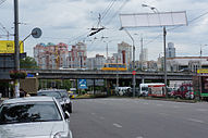 Traffic junction on Lybidska Square
 -
 Entrance to Lybidska metro station
 -
 The Pyrohiv museum is located within the raion


Notes
References
- ^ "Рідні мови в об'єднаних територіальних громадах України" (in Ukrainian).
External links
- Holosiivskyi District Administration website (in Ukrainian)
- Голосіїв Archived 2007-08-09 at the Wayback Machine in Wiki-Encyclopedia Kyiv Archived 2007-11-07 at the Wayback Machine (in Ukrainian)
50°20′20″N 30°33′15″E / 50.33889°N 30.55417°E
| International | |
|---|---|
| National | |