


Original file (SVG file, nominally 1,410 × 1,109 pixels, file size: 197 KB)
![]() ✓
The source code of this SVG is valid.
✓
The source code of this SVG is valid.
Summary
| Description |
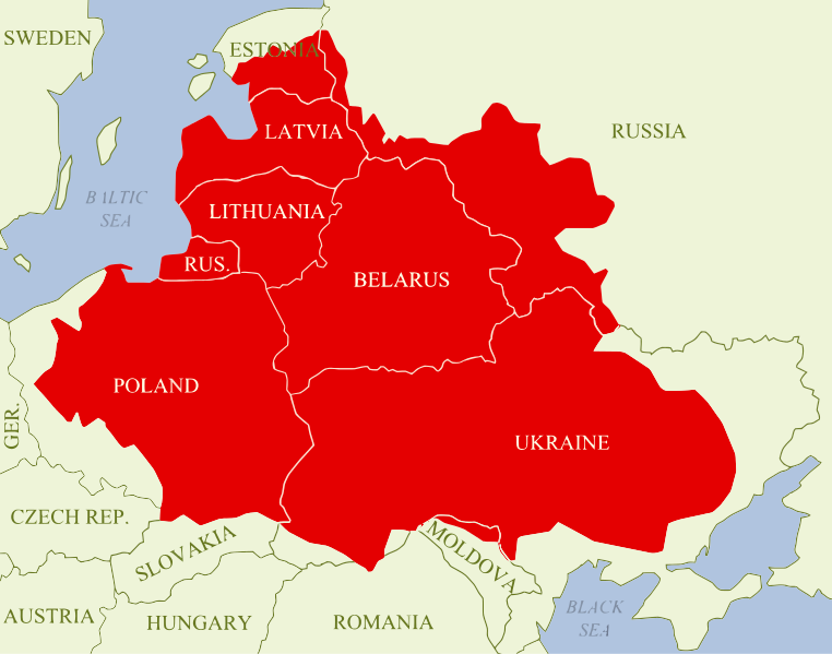
A map showing the Polish–Lithuanian Commonwealth at its maximum extent following the Truce of Деулино, superimposed on present-day national borders. The map shows in red all of the territory that was ruled by Zygmunt III Waza in 1619 (the Polish monarch at that time), which made up the Commonwealth; it can be further divided up into:
In the early 17th century, the Polish-Lithuanian Commonwealth was one of the largest and most populous countries in Europe, comprising about 1,000,000 km2 (390,000 sq mi) of land with a population of some 12 000 000 people (5m Ruthenians, 4.5m Poles, 0.75m Lithuanians, 0.75m Prussians, 0.5m Jews and 0.5m Livionians). As can be seen on the map, the Commonwealth's territory was - in terms of present-day borders - equal to: most of Poland and Ukraine; all of Belarus, Lithuania, Latvia and the Kaliningrad Oblast; much of Estonia; parts of Russia (including Smoleńsk); as well as small parts of Moldova and Romania. |
|---|---|
| Source |
Created by me using graphics editing software, then converted to SVG format. It is based on this design: https://commons.wikimedia.org/wiki/File:Rzeczpospolita2nar.png |
| Date |
2014-05-22 |
| Author | |
| Permission (Reusing this file) |
See below.
|
Licensing
File history
Click on a date/time to view the file as it appeared at that time.
| Date/Time | Thumbnail | Dimensions | User | Comment | |
|---|---|---|---|---|---|
| current | 23:05, 22 May 2014 | | 1,410 × 1,109 (197 KB) | Pitsarotta (talk | contribs) | Uploading a self-made file using File Upload Wizard |
You cannot overwrite this file.
File usage
The following file is a duplicate of this file (more details):
The following 5 pages use this file: