


Road 77, also known as the Haraz Road, is one of the most important roads from Tehran to the northern mountains of Iran, and the Iranian coast on the southern Caspian Sea. Amol is the first northern city of this road.[1] Along the road landscapes, Plain, Mountain, Historical tourism. Waterfall and village.
Route
The road's route travels through Tehran Province and Mazandaran Province. It crosses the Alborz mountain range and then descends northwards down the Haraz River Valley. The road is the shortest route from Tehran to the north ( 180 km). It passes through the towns of Amol and Rudehen.
Features
Haraz Road is the nearest road to Mount Damavand. Lar Dam, Lar National Park, which Mount Damavand is within, is accessible from Road 77.
Central Alborz mountain range map
| Map of central Alborz | Peaks: | 1 Alam-Kuh |
|---|---|---|
 −25 to 500 m (−82 to 1,640 ft) 500 to 1,500 m (1,600 to 4,900 ft) 1,500 to 2,500 m (4,900 to 8,200 ft) 2,500 to 3,500 m (8,200 to 11,500 ft) 3,500 to 4,500 m (11,500 to 14,800 ft) 4,500 to 5,610 m (14,760 to 18,410 ft) |
2 Azad Kuh | 3 Damavand |
| 4 Do Berar | 5 Do Khaharan | |
| 6 Ghal'eh Gardan | 7 Gorg | |
| 8 Kholeno | 9 Mehr Chal | |
| 10 Mishineh Marg | 11 Naz | |
| 12 Shah Alborz | 13 Sialan | |
| 14 Tochal | 15 Varavašt | |
| Rivers: | 0 | |
| 1 Alamut | 2 Chalus | |
| 3 Do Hezar | 4 Haraz | |
| 5 Jajrood | 6 Karaj | |
| 7 Kojoor | 8 Lar | |
| 9 Noor | 10 Sardab | |
| 11 Seh Hazar | 12 Shahrood | |
| Cities: | 1 Amol | |
| 2 Chalus | 3 Karaj | |
| Other: | D Dizin | |
| E Emamzadeh Hashem | K Kandovan Tunnel | |
| * Latyan Dam | ** Lar Dam |
Gallery
-
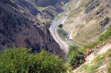 Road view from above
 -
 Initial view of the north
 -
 Haraz road Tunnel
 -
 Snow in Mosha village on Haraz road
 -
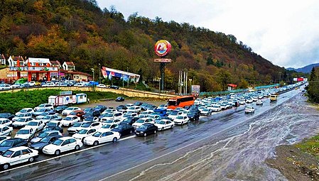 Traffic in Narenjestan area, Haraz road Amol
 -
 American tourists on Haraz road, Polur Amol


See also
- Road 59 − Karaj-Chaloos Road — another main Tehran−Caspian route.
- Alborz (Elburz) mountain range topics
References
- ^ "نقشه راههای ایران با بزرگنمایی بینهایت" (PDF). مشرق نیوز (in Persian). 2015-03-23. Retrieved 2019-11-02.
External links
| Freeways |
| |||||
|---|---|---|---|---|---|---|
| First-Class Roads | ||||||
You must be logged in to post a comment.