Size of this preview: 546 × 599 pixels. Other resolutions: 219 × 240 pixels | 437 × 480 pixels | 699 × 768 pixels | 933 × 1,024 pixels | 1,865 × 2,048 pixels | 4,390 × 4,820 pixels.
Original file (4,390 × 4,820 pixels, file size: 9.65 MB, MIME type: image/jpeg)
File history
Click on a date/time to view the file as it appeared at that time.
| Date/Time | Thumbnail | Dimensions | User | Comment | |
|---|---|---|---|---|---|
| current | 05:01, 26 April 2015 |  | 4,390 × 4,820 (9.65 MB) | Chumwa | some enhancements |
| 08:08, 4 August 2012 |  | 4,152 × 4,632 (3.49 MB) | Mallowtek | remove border and improve contrast | |
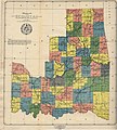
| 02:37, 16 July 2007 |  | 4,517 × 5,009 (3.91 MB) | Ravedave | {{Information |Description= This map of the ‘State of Sequoyah’ - complete with a proposed State Seal - was compiled from the USGS Map of Indian Territory (1902), revised to include the county divisions made under direction of Sequoyah Statehood Conve |
File usage
The following 5 pages use this file:
Global file usage
The following other wikis use this file:
- Usage on bcl.wikipedia.org
- Usage on be.wikipedia.org
- Usage on ca.wikipedia.org
- Usage on de.wikipedia.org
- Usage on it.wikipedia.org
- Usage on ru.wikipedia.org
- Проект:Тематическая неделя/Неделя южных штатов
- Секвойя (штат)
- Проект:Тематическая неделя/Неделя Соединённых Штатов Америки
- Проект:Тематическая неделя/II Неделя Соединённых Штатов Америки
- Проект:Тематическая неделя/III Неделя Соединённых Штатов Америки
- Проект:Тематическая неделя/IV Неделя Соединённых Штатов Америки
- Проект:Тематическая неделя англоязычных регионов мира/Неделя Соединённых Штатов Америки
- Usage on uk.wikipedia.org


