


File:The approach to Tappoch Broch - geograph.org.uk - 1024864.jpg
No higher resolution available.
The_approach_to_Tappoch_Broch_-_geograph.org.uk_-_1024864.jpg (640 × 480 pixels, file size: 123 KB, MIME type: image/jpeg)
Summary
| Description |
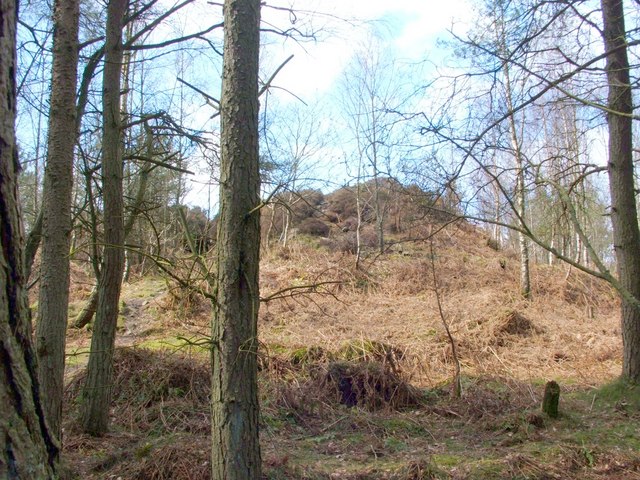
English: The approach to Tappoch Broch. The passageway that was the main entrance to this broch is located on its near side (the eastern side). As this view shows, the broch appears, from the outside, to be little more than a steep mound; however, the well-preserved interior retains many features of interest. For further details, and for a view of the inner walls, see the main article, 1024921, which has links to other views of the interior. |
| Date | |
| Source | From geograph.org.uk |
| Author | Lairich Rig |
| Attribution (required by the license) | Lairich Rig / The approach to Tappoch Broch / |
| Camera location | | View this and other nearby images on: OpenStreetMap |
|---|
_heading:292.00&language=en)
| Object location | | View this and other nearby images on: OpenStreetMap |
|---|
_heading:292.00&language=en)
Licensing

|
This image was taken from the Geograph project collection. See this photograph's page on the Geograph website for the photographer's contact details. The copyright on this image is owned by Lairich Rig and is licensed for reuse under the Creative Commons Attribution-ShareAlike 2.0 license.
|
This file is licensed under the Creative Commons Attribution-Share Alike 2.0 Generic license.
Attribution:
Lairich Rig
- You are free:
- to share – to copy, distribute and transmit the work
- to remix – to adapt the work
- Under the following conditions:
- attribution – You must give appropriate credit, provide a link to the license, and indicate if changes were made. You may do so in any reasonable manner, but not in any way that suggests the licensor endorses you or your use.
- share alike – If you remix, transform, or build upon the material, you must distribute your contributions under the same or compatible license as the original.
File history
Click on a date/time to view the file as it appeared at that time.
| Date/Time | Thumbnail | Dimensions | User | Comment | |
|---|---|---|---|---|---|
| current | 15:50, 23 February 2011 | | 640 × 480 (123 KB) | GeographBot | == {{int:filedesc}} == {{Information |description={{en|1=The approach to Tappoch Broch The passageway that was the main entrance to this broch is located on its near side (the eastern side). As this view shows, the broch appears, from the outside, to be l |
File usage
The following page uses this file: