


Groningen (province): Difference between revisions
→External links: Add geographic location box |
expand Geography / add image to infobox / unreferenced |
||
| Line 4: | Line 4: | ||
| native_name = |
| native_name = |
||
| native_name_lang = nl |
| native_name_lang = nl |
||
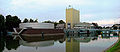
| image_skyline = 100523 Grote Markt en Martinitoren Groningen NL.jpg |
|||
| image_alt = |
|||
| image_caption = The market and the [[Martinitoren]] in the capital [[Groningen]] |
|||
| image_shield = Groningen provincie wapen.svg |
| image_shield = Groningen provincie wapen.svg |
||
| image_flag = Flag of Groningen.svg |
| image_flag = Flag of Groningen.svg |
||
| Line 39: | Line 42: | ||
==Geography== |
==Geography== |
||
Groningen is situated in the north of the [[Netherlands]]. With to the west the province [[Friesland|Frisia]], to the south the province [[Drenthe]], to the east the German state [[Lower Saxony]], and to the north the [[Wadden Sea]], [[Ems (river)|Ems]], and [[Dollart]]. |
|||
{{Expand section|date=April 2008}} |
|||
In the Wadden Sea of Groningen, a [[World Heritage Site|UNESCO World Heritage Site]] since 2009, there is a large sandbank [[Simonszand]] and three uninhabited islands [[Rottumeroog]], [[Rottumerplaat]], and [[Zuiderduintjes]]. The [[Lauwersmeer National Park]] is located on the border between Groningen and Frisia. |
|||
Land use in Groningen is mainly agricultural; it has a large [[natural gas field]] near [[Slochteren]]. |
Land use in Groningen is mainly agricultural; it has a large [[natural gas field]] near [[Slochteren]]. |
||
But, Groningen has many historical monuments and many old buildings in almost every village. |
|||
==History== |
==History== |
||
| ⚫ | |||
Originally a part of [[Frisia]], Groningen became a part of the [[Frankish Empire]] around 785. [[Charlemagne]] assigned the Christianization of this new possession to [[Ludger]]. In the 11th century, the city of Groningen was a village in [[Drenthe]] that belonged to the [[Bishopric of Utrecht]], while most of the province was in the [[diocese of Münster]]. During the Middle Ages, central control was remote, and the city of Groningen acted as a [[city state]], exerting a dominating influence on the surrounding [[Ommelanden]]. Around 1500, [[Maximilian I, Holy Roman Emperor]] gave Groningen and Friesland to [[Albert, Duke of Saxony]], who could however not establish permanent control. In 1514/15 Groningen came to the Duchy of [[Guelders]], and in 1536 to the [[Habsburg Netherlands]]. In 1594, Groningen was conquered by the [[United Netherlands]], to which it belonged henceforth. |
Originally a part of [[Frisia]], Groningen became a part of the [[Frankish Empire]] around 785. [[Charlemagne]] assigned the Christianization of this new possession to [[Ludger]]. In the 11th century, the city of Groningen was a village in [[Drenthe]] that belonged to the [[Bishopric of Utrecht]], while most of the province was in the [[diocese of Münster]]. During the Middle Ages, central control was remote, and the city of Groningen acted as a [[city state]], exerting a dominating influence on the surrounding [[Ommelanden]]. Around 1500, [[Maximilian I, Holy Roman Emperor]] gave Groningen and Friesland to [[Albert, Duke of Saxony]], who could however not establish permanent control. In 1514/15 Groningen came to the Duchy of [[Guelders]], and in 1536 to the [[Habsburg Netherlands]]. In 1594, Groningen was conquered by the [[United Netherlands]], to which it belonged henceforth. |
||
| Line 109: | Line 113: | ||
* [[Noisia]], Band |
* [[Noisia]], Band |
||
* [[Daniel Bernoulli]], mathematician |
* [[Daniel Bernoulli]], mathematician |
||
==References== |
|||
| ⚫ | |||
{{reflist}} |
|||
==External links== |
==External links== |
||
Revision as of 15:21, 2 January 2014
Groningen | |
|---|---|
Province of the Netherlands | |
 The market and the Martinitoren in the capital Groningen | |
| Anthem: Grunnens Laid | |
 Location of Groningen in the Netherlands | |
| Country | Netherlands |
| Capital | Groningen |
| Government | |
| • King's Commissioner | Max van den Berg |
| Area | |
• Land | 2,329 km2 (899 sq mi) |
| • Water | 576 km2 (222 sq mi) |
| • Rank | 8th |
| Population (2006) | |
• Land | 574,042 |
| • Rank | 9th |
| • Density | 246.5/km2 (638.4/sq mi) |
| • Rank | 9th |
| ISO 3166 code | NL-GR |
| Religion (2005) | Protestant 18.0% Catholic 4.6% Muslim 2.5% |
| Website | provinciegroningen.nl |


Groningen (Template:IPA-nl; Gronings: Grönnen; Template:Lang-fry) is the northeasternmost province of the Netherlands. In the east it borders the German state of Niedersachsen (districts of Leer and Emsland), in the south Drenthe, in the west Friesland and in the north the Wadden Sea. The capital of the province is the city of Groningen.
Geography
Groningen is situated in the north of the Netherlands. With to the west the province Frisia, to the south the province Drenthe, to the east the German state Lower Saxony, and to the north the Wadden Sea, Ems, and Dollart.
In the Wadden Sea of Groningen, a UNESCO World Heritage Site since 2009, there is a large sandbank Simonszand and three uninhabited islands Rottumeroog, Rottumerplaat, and Zuiderduintjes. The Lauwersmeer National Park is located on the border between Groningen and Frisia.
Land use in Groningen is mainly agricultural; it has a large natural gas field near Slochteren.
History
Originally a part of Frisia, Groningen became a part of the Frankish Empire around 785. Charlemagne assigned the Christianization of this new possession to Ludger. In the 11th century, the city of Groningen was a village in Drenthe that belonged to the Bishopric of Utrecht, while most of the province was in the diocese of Münster. During the Middle Ages, central control was remote, and the city of Groningen acted as a city state, exerting a dominating influence on the surrounding Ommelanden. Around 1500, Maximilian I, Holy Roman Emperor gave Groningen and Friesland to Albert, Duke of Saxony, who could however not establish permanent control. In 1514/15 Groningen came to the Duchy of Guelders, and in 1536 to the Habsburg Netherlands. In 1594, Groningen was conquered by the United Netherlands, to which it belonged henceforth.
Groningen was one of the towns within the hanseatic league during the Middle Ages.
Political history
East Groningen was the scene of a particularly fierce class struggle in the 19th and 20th centuries. Perhaps not coincidentally, Groningen boasts the only municipality (Beerta) where the Communist Party of the Netherlands has ever had a mayor (Hanneke Jagersma).
Culture
-
 The Martinitoren, Icon of the provincial capital of Groningen
 -
 The Groninger Museum
 -
 The Fraeylemaborg nearby Slochteren
 -
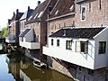 The hanging kitchens of Appingedam


Dialect
Groningen is home to a typical Low Saxon dialect called Gronings (Grönnegs / Grunnegs in Gronings regional language), with local nuances. Nowadays, many inhabitants of the province do not speak the dialect, especially in the city of Groningen where many outsiders have moved.
Municipalities
- Appingedam
- Bedum
- Bellingwedde
- De Marne
- Delfzijl
- Eemsmond
- Groningen
- Grootegast
- Haren
- Hoogezand-Sappemeer
- Leek
- Loppersum
- Marum
- Menterwolde
- Oldambt
- Pekela
- Slochteren
- Stadskanaal
- Ten Boer
- Veendam
- Vlagtwedde
- Winsum
- Zuidhorn
People from Groningen Province
- Abel Tasman, Explorer
- Cornelis Dopper, conductor and composer
- Albert Eckhout, painter
- Ede Staal, singer-songwriter
- Wiebbe Hayes, a Dutch soldier and national hero in the 17th century
- Lenie 't Hart, animal rights activist
- Jozef Israëls, painter
- Aletta Jacobs, first woman to study medicine in the Netherlands
- Freek de Jonge, cabaret artist
- Jurrie Koolhof, former football striker. Played 106 matches for PSV Eindhoven
- Gerrit Krol, writer
- Jan Mulder, former football player. Played for Ajax Amsterdam
- Arjen Robben, footballer
- Autumn, Band
- Noisia, Band
- Daniel Bernoulli, mathematician
References
External links
- Website of the Province Template:Nl
- Flag
- Website of the Capital City
- Alternative Website of the Capital City (Local Shops and Small Businesses) Template:Nl
- Map of Groningen Template:Nl
- Website of the University
- Website of the Polytechnic Template:Nl
- Map of Province Template:Nl
 Edmondo De Amicis, Holland and its People, translated from the Italian by Caroline Tilton, Chapter XVI, 1890.
Places adjacent to Groningen (province) | ||||||||||||||||
|---|---|---|---|---|---|---|---|---|---|---|---|---|---|---|---|---|
| ||||||||||||||||
 | ||
|  | |||||
| County | ||||||
| Cities | ||||||
| Dependent territories | ||||||
1 until 1648; 2 until 1659; 3 until 1678.
Circles est. 1500: Bavarian, Swabian, Upper Rhenish, Lower Rhenish–Westphalian, Franconian, (Lower) Saxon Circles est. 1512: Austrian, Burgundian, Upper Saxon, Electoral Rhenish · Unencircled territories | ||||||