


Victoria Bridge, Brisbane: Difference between revisions
| Line 84: | Line 84: | ||
[[Category:History of Brisbane]] |
[[Category:History of Brisbane]] |
||
[[Category:Crossings of the Brisbane River]] |
[[Category:Crossings of the Brisbane River]] |
||
[[Category:Road bridges]] |
|||
[[Category:Concrete bridges]] |
|||
Revision as of 07:03, 4 March 2010
Victoria Bridge | |
|---|---|
 Victoria Bridge | |
| Coordinates | 27°28′21″S 153°01′16″E / 27.4725°S 153.021°E |
| Carries | Motor vehicles, pedestrians and cyclists |
| Crosses | Brisbane River |
| Locale | Brisbane, Queensland, Australia |
| Characteristics | |
| Material | Concrete |
| Total length | 313 m |
| No. of spans | 3 |
| History | |
| Designer | Coordinator General's Department |
| Construction end | 1969 |
| Opened | 1969 |
| Location | |
 Interactive map of Victoria Bridge | |
The Victoria Bridge is a vehicular and pedestrian bridge over the Brisbane River. The current bridge, opened in 1969, is the third permanent crossing erected at this location.
It is shared by vehicular traffic, pedestrians and cyclists.
Victoria Bridge connects the South Bank Parklands and Queensland Cultural Centre to the Brisbane central business district (CBD) at North Quay.
Half of the road space on the bridge is now given over to the South-East Busway. In the Brisbane City Centre Draft Masterplan, a new crossing immediately adjacent to the Victoria Bridge, tentatively named the Adelaide Street Bridge (the name of the connecting street in the CBD), will carry pedestrian, cyclist, bus and possibly light-rail traffic, freeing up the Victoria Bridge for general road traffic as it was before.[citation needed]
Former bridges at this site

The original bridge at this point on the river was a timber structure that opened in June 1865. This structure quickly succumbed to marine wood worm and collapsed in April 1867.[1][2]
A new crossing, opened in June 1874 by the Governor of Queensland, the Marquis of Normanby, was an iron structure and a toll bridge.[1] The bridge was payed for by significant council borrowings that were to be recouped by tolls.[3] However a lack of revenue forced its transfer to the Colonial Government.[3] It included a turning span to allow tall masted river traffic to pass upstream. The position was fixed when the tram-lines were laid along the bridge.[4] It carried a 6 in (0.15 m) and a 9 in (0.23 m) diameter pipe which supplied mains water to South Brisbane.[5] This bridge was partially washed away in the floods of 1893.[1][6]

Another replacement bridge was built and entered service in 1897, lasting until 1969, when it was demolished.[1] In the meantime, ferries were used to transport people and goods. This second bridge was designed by A.B. Brady. It was constructed of steel and had two carriage ways and two footpaths.[4]
A new bridge which was opened in January 1969, was needed to meet growing traffic demands.[6] It cost AUD$3.2 million and featured a modern design which has been described as sleek and elegant.[4] For a short period both bridges were open, each operating in one direction only.[4]
A portion of the southern abutment of the previous bridge remains adjacent to the new bridge, carrying a pedestrian arch, a short remnant of tram track and a memorial to Hector Vasyli, a young boy who was killed in a traffic accident at that point when waving to servicemen returning from the First World War.
Gallery
-
 Victoria Bridge
 -
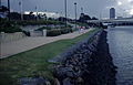 Southern bank pedestrian underpass and bridge
 -
 Victoria Bridge. Photo taken from the overhead pedestrian bridge at the Cultural Centre Busway Station
 -
 HDR of Victoria Bridge


See also
References
- ^ a b c d Hadwen, Ian (2005). Brisbane's historic North Bank 1825 - 2005. Brisbane: Royal Historial Society of Queensland. pp. 62–65. ISBN 0975761501.
{{cite book}}: Unknown parameter|coauthors=ignored (|author=suggested) (help) - ^ Longhurst, Robert. The Brisbane River: A pictorial history. Brisbane: W.D. Incorporated Pty Ltd. p. 23. ISBN 0646344722.
{{cite book}}: Unknown parameter|coauthors=ignored (|author=suggested) (help) - ^ a b Cole, John R. (1984). Shaping a city. Albion, Queensland: William Brooks Queensland. p. 19. ISBN 0855686197.
- ^ a b c d Hogan, Janet (1982). Living History of Brisbane. Spring Hill, Queensland: Boolarang Publications. pp. 45, 77, 124. ISBN 0908175418.
{{cite book}}: Cite has empty unknown parameter:|coauthors=(help) - ^ Oliver, Bill (2008). Carolyn Fitz-Gerald (ed.). "Floods, water quality and river crossings, Mount Crosby 1890-1931". Brisbane:Water, Power and Industry Paper No. 20. Kelvin Grove, Queensland: Brisbane History Group: 31. ISBN 9780975179338.
- ^ a b Gregory, Helen (2007). Brisbane Then and Now. Wingfield, South Australia: Salamander Books. pp. 8–9. ISBN 9781741730111.
{{cite book}}: Cite has empty unknown parameter:|coauthors=(help)