


Panola, Oklahoma
Panola, Oklahoma | |
|---|---|
 Panola  Panola | |
| Coordinates: 34°55′43″N 95°12′48″W / 34.92861°N 95.21333°W | |
| Country | United States |
| State | Oklahoma |
| County | Latimer |
| Area | |
• Total | 1.13 sq mi (2.92 km2) |
| • Land | 1.12 sq mi (2.90 km2) |
| • Water | 0.0077 sq mi (0.02 km2) |
| Elevation | 642 ft (196 m) |
| Population (2020) | |
• Total | 73 |
| • Density | 65.1/sq mi (25.13/km2) |
| Time zone | UTC-6 (Central (CST)) |
| • Summer (DST) | UTC-5 (CDT) |
| FIPS code | 40-56950 |
| GNIS feature ID | 1096396 |
Panola is a small unincorporated community and census-designated place in Latimer County, Oklahoma, United States. The post office was established March 18, 1911. Panola is the Choctaw name for cotton. The high school and gymnasium are on the National Register of Historic Places. The population was 73 at the time of the 2020 Census.[2]
Demographics
| Census | Pop. | Note | %± |
|---|---|---|---|
| 2020 | 73 | — | |
| U.S. Decennial Census[2] | |||
2020 census
As of the 2020 census, Panola had a population of 73. The median age was 40.5 years. 27.4% of residents were under the age of 18 and 24.7% of residents were 65 years of age or older. For every 100 females there were 69.8 males, and for every 100 females age 18 and over there were 103.8 males age 18 and over.[3][4]
0.0% of residents lived in urban areas, while 100.0% lived in rural areas.[5]
There were 35 households in Panola, of which 11.4% had children under the age of 18 living in them. Of all households, 20.0% were married-couple households, 37.1% were households with a male householder and no spouse or partner present, and 42.9% were households with a female householder and no spouse or partner present. About 77.2% of all households were made up of individuals and 71.5% had someone living alone who was 65 years of age or older.[3]
There were 40 housing units, of which 12.5% were vacant. The homeowner vacancy rate was 2.8% and the rental vacancy rate was 0.0%.[3]
| Race | Number | Percent |
|---|---|---|
| White | 50 | 68.5% |
| Black or African American | 0 | 0.0% |
| American Indian and Alaska Native | 20 | 27.4% |
| Asian | 0 | 0.0% |
| Native Hawaiian and Other Pacific Islander | 0 | 0.0% |
| Some other race | 0 | 0.0% |
| Two or more races | 3 | 4.1% |
| Hispanic or Latino (of any race) | 2 | 2.7% |
References
- ^ "ArcGIS REST Services Directory". United States Census Bureau. Retrieved September 20, 2022.
- ^ a b "Panola (CDP), Oklahoma". United States Census Bureau. Retrieved June 13, 2023.
- ^ a b c "2020 Decennial Census Demographic Profile (DP1)". United States Census Bureau. 2021. Retrieved January 31, 2026.
- ^ a b "2020 Decennial Census Redistricting Data (Public Law 94-171)". United States Census Bureau. 2021. Retrieved January 31, 2026.
- ^ "2020 Decennial Census Demographic and Housing Characteristics (DHC)". United States Census Bureau. 2023. Retrieved January 31, 2026.
External links
- Panola Public School District Archived December 17, 2005, at the Wayback Machine
- Oklahoma Digital Maps: Digital Collections of Oklahoma and Indian Territory
Municipalities and communities of Latimer County, Oklahoma, United States | ||
|---|---|---|
| City | 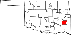 | |
| Towns | ||
| CDPs | ||
| Indian reservation | ||
| Footnotes | ‡This populated place also has portions in another county or counties | |