


Harrisville, Mississippi
Harrisville, Mississippi | |
|---|---|
 Harrisville, Mississippi  Harrisville, Mississippi | |
| Coordinates: 31°58′20″N 90°04′40″W / 31.97222°N 90.07778°W | |
| Country | United States |
| State | Mississippi |
| County | Simpson |
| Elevation | 420 ft (130 m) |
| Time zone | UTC-6 (Central (CST)) |
| • Summer (DST) | UTC-5 (CDT) |
| ZIP code | 39082 |
| Area codes | 601 & 769 |
| GNIS feature ID | 670985[1] |
Harrisville is an unincorporated community in Simpson County, Mississippi, United States.[1] Its zip code is 39082.[2]
Harrisville sits mainly at the junction between Mississippi Highway 469, which connects to Florence and Pinola, and Highway 540, which connects to D'Lo. The community is part of the Jackson Metropolitan Statistical Area. The two main churches are the Harrisville United Methodist Church and the Harrisville Baptist Church.[3]
In 1900, Harrisville had a population of 68 and had several stores, churches, and a cotton gin.[4]
Harrisville is served by the Harrisville Volunteer Fire Department and the Harrisville Public Library.[5][6]
References
- ^ a b "Harrisville, Mississippi". Geographic Names Information System. United States Geological Survey, United States Department of the Interior.
- ^ United States Postal Service (2012). "USPS - Look Up a ZIP Code". Retrieved October 10, 2025.
- ^ "Harrisville, Mississippi". Mississippi Hometown Locator. Retrieved October 10, 2025.
- ^ Rowland, Dunbar (1907). Mississippi: Comprising Sketches of Counties, Towns, Events, Institutions, and Persons, Arranged in Cyclopedic Form. Vol. 1. Southern Historical Publishing Association. p. 848.
- ^ "Simpson County". Simpson County, Mississippi. Retrieved October 10, 2025.
- ^ "Harrisville Public Library". Central Mississippi Regional Library System. Retrieved October 10, 2025.
Municipalities and communities of Simpson County, Mississippi, United States | ||
|---|---|---|
| Cities | 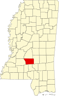 | |
| Town | ||
| Village | ||
| Unincorporated communities | ||
| Ghost town | ||