


Nandaprayag
Nandaprayag | |
|---|---|
Town | |
 The Nandakini River (foreground) meets the Alaknanda River (background) in Nandaprayag | |
 Nandaprayag Location in Uttarakhand, India | |
| Coordinates: 30°20′N 79°20′E / 30.33°N 79.33°E | |
| Country | |
| State | Uttarakhand |
| District | Chamoli |
| Elevation | 914 m (2,999 ft) |
| Population (2001) | |
• Total | 1,433 |
| Languages | |
| • Official | Hindi |
| Time zone | UTC+5:30 (IST) |
| PIN | 246449[1] |

Nandaprayag is a town and a nagar panchayat in Chamoli district in the Indian state of Uttarakhand. Nandaprayag is one of the Panch Prayag (five confluences) of Alaknanda River and lies at the confluence of the Alaknanda River and Nandakini River.[2] Nandaprayag was once the capital of the Yadu kingdom.
Geography
Nandaprayag is located at 30°20′N 79°20′E / 30.33°N 79.33°E. It has an average elevation of 1,358 metres (4,455 feet).
Demographics
As of 2001 India census,[3] Nandaprayag had a population of 1433. Males constitute 56% of the population and females 44%. Nandaprayag has an average literacy rate of 70%, higher than the national average of 59.5%: male literacy is 78%, and female literacy is 61%. In Nandaprayag, 13% of the population is under 6 years of age.
Gallery
-
 Another view of the confluence of the Nandakini River (foreground) and the Alaknanda River (background) at Nandprayag
 -
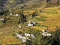 Bangali village near Nandprayag.


References
- ^ "Nandprayag Pin code". pin-code.net. Retrieved 31 July 2021.
- ^ Uttaranchal. Rupa & Co. 2006. ISBN 81-291-0861-5. Page 12
- ^ "Census of India 2001: Data from the 2001 Census, including cities, villages and towns (Provisional)". Census Commission of India. Archived from the original on 16 June 2004. Retrieved 1 November 2008.