


Malsburg-Marzell
Malsburg-Marzell | |
|---|---|
 Coat of arms | |
Location of Malsburg-Marzell
within Lörrach district 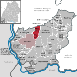 | |
 Location of Malsburg-Marzell | |
 Malsburg-Marzell  Malsburg-Marzell | |
| Coordinates: 47°46′15″N 07°43′32″E / 47.77083°N 7.72556°E | |
| Country | Germany |
| State | Baden-Württemberg |
| Admin. region | Freiburg |
| District | Lörrach |
| Government | |
| • Mayor (2018–26) | Mario Thomas Singer[1] |
| Area | |
• Total | 24.92 km2 (9.62 sq mi) |
| Elevation | 495 m (1,624 ft) |
| Population (2023-12-31)[2] | |
• Total | 1,455 |
| • Density | 58.39/km2 (151.2/sq mi) |
| Time zone | UTC+01:00 (CET) |
| • Summer (DST) | UTC+02:00 (CEST) |
| Postal codes | 79429 |
| Dialling codes | 07626 |
| Vehicle registration | LÖ |
| Website | www.malsburg-marzell.de |

Malsburg-Marzell is a municipality in the district of Lörrach in Baden-Württemberg in Germany. Its coat of arms bears a wooded hill on which rests a castle ruin. This is a reference to the nearby Sausenburg.
In the municipal area southeast of Hochblauen lies what is probably the highest castle site in Baden-Württemberg, Stockburg Castle .
Demographics
Population development:[3]
|
References
- ^ Aktuelle Wahlergebnisse, Staatsanzeiger, accessed 13 September 2021.
- ^ "Alle politisch selbständigen Gemeinden mit ausgewählten Merkmalen am 31.12.2023" (in German). Federal Statistical Office of Germany. 28 October 2024. Retrieved 16 November 2024.
- ^ "Malsburg-Marzell (Lörrach, Baden-Württemberg, Deutschland) - Einwohnerzahlen, Grafiken, Karte, Lage, Wetter und Web-Informationen". citypopulation.de. Retrieved 2023-06-22.
