


Costilla County, Colorado
Costilla County, Colorado | |
|---|---|
 The Costilla County Courthouse in San Luis | |
 Location within the U.S. state of Colorado | |
| Coordinates: 37°17′N 105°26′W / 37.28°N 105.43°W | |
| Country | |
| State | |
| Founded | November 1, 1861 |
| Seat | San Luis |
| Largest town | San Luis |
| Area | |
• Total | 1,230 sq mi (3,200 km2) |
| • Land | 1,227 sq mi (3,180 km2) |
| • Water | 3.4 sq mi (8.8 km2) 0.3% |
| Population (2020) | |
• Total | 3,499 |
• Estimate (2024) | 3,686 |
| • Density | 2.852/sq mi (1.101/km2) |
| Time zone | UTC−7 (Mountain) |
| • Summer (DST) | UTC−6 (MDT) |
| Congressional district | 3rd |
| Website | costillacounty |
| Colorado's first permanent settlement | |
Costilla County (Spanish for "rib") is a county located in the U.S. state of Colorado. As of the 2020 census, the population was 3,499.[1] The county seat is San Luis,[2] the oldest continuously occupied town in Colorado.
History
On July 8, 1694, Spanish Conquistador Don Diego de Vargas and his army, two weeks before the Battle of Astialakwa, reached Costilla County. Diego Vargas is not the first Spaniard in Colorado. Juan de Archuleta led an expedition into Colorado in 1664 – his expedition is the first traceable Spanish expedition into Colorado.[3] In 1647, Governor Luis Rosas fought with the Utes in northern New Mexico. While Rosa came near Colorado, it has not been verified he actually did.
Costilla County was the first area of Colorado to have been colonized. The county made up the major part of the Sangre de Cristo Land Grant awarded by the government of New Mexico to the Carlos Beaubien family in 1843. Hispanic settlers from Taos, New Mexico, officially established San Luis on April 9, 1851.[4] Costilla County was one of the original 17 counties created by the Territory of Colorado on November 1, 1861. The county was named for Costilla Creek. San Miguel was originally designated the county seat, but the county government was moved to San Luis in 1863. (In 1869, surveys placed San Miguel in the New Mexico Territory.)
The county's original boundaries extended over much of south-central Colorado. Much of the northern portion became part of Saguache County in 1866, and the western portions were folded into Hinsdale and Rio Grande counties in 1874. Costilla County arrived at its modern boundaries in 1913 when Alamosa County was created from its northwest portions.[5]
Geography
According to the U.S. Census Bureau, the county has a total area of 1,230 square miles (3,200 km2), of which 1,227 square miles (3,180 km2) is land and 304 square miles (790 km2) (0.3%) is water.[6]
Adjacent counties
- Huerfano County - northeast
- Las Animas County - east
- Colfax County, New Mexico - southeast
- Taos County, New Mexico - south
- Conejos County - west
- Alamosa County - northwest
Major highways
National protected area
Historic trails and sites
- Fort Garland State History Museum
- Los Caminos Antiguos Scenic and Historic Byway
- Old Spanish National Historic Trail
Demographics
| Census | Pop. | Note | %± |
|---|---|---|---|
| 1870 | 1,779 | — | |
| 1880 | 2,879 | 61.8% | |
| 1890 | 3,491 | 21.3% | |
| 1900 | 4,632 | 32.7% | |
| 1910 | 5,498 | 18.7% | |
| 1920 | 5,032 | −8.5% | |
| 1930 | 5,779 | 14.8% | |
| 1940 | 7,533 | 30.4% | |
| 1950 | 6,067 | −19.5% | |
| 1960 | 4,219 | −30.5% | |
| 1970 | 3,091 | −26.7% | |
| 1980 | 3,071 | −0.6% | |
| 1990 | 3,190 | 3.9% | |
| 2000 | 3,663 | 14.8% | |
| 2010 | 3,524 | −3.8% | |
| 2020 | 3,499 | −0.7% | |
| 2024 (est.) | 3,686 | [7] | 5.3% |
| U.S. Decennial Census[8] 1790-1960[9] 1900-1990[10] 1990-2000[11] 2010-2020[1] | |||
2020 census
As of the 2020 census, the county had a population of 3,499. Of the residents, 17.7% were under the age of 18 and 27.9% were 65 years of age or older; the median age was 52.2 years. For every 100 females there were 109.1 males, and for every 100 females age 18 and over there were 107.1 males. 0.0% of residents lived in urban areas and 100.0% lived in rural areas.[12][13][14]
| Race / Ethnicity (NH = Non-Hispanic) | Pop 2000[15] | Pop 2010[16] | Pop 2020[17] | % 2000 | % 2010 | % 2020 |
|---|---|---|---|---|---|---|
| White alone (NH) | 1,033 | 1,086 | 1,234 | 28.20% | 30.82% | 35.27% |
| Black or African American alone (NH) | 21 | 6 | 33 | 0.57% | 0.17% | 0.94% |
| Native American or Alaska Native alone (NH) | 39 | 29 | 34 | 1.06% | 0.82% | 0.97% |
| Asian alone (NH) | 34 | 34 | 55 | 0.93% | 0.96% | 1.57% |
| Pacific Islander alone (NH) | 1 | 0 | 0 | 0.03% | 0.00% | 0.00% |
| Other race alone (NH) | 5 | 12 | 13 | 0.14% | 0.34% | 0.37% |
| Mixed race or Multiracial (NH) | 54 | 30 | 142 | 1.47% | 0.85% | 4.06% |
| Hispanic or Latino (any race) | 2,476 | 2,327 | 1,988 | 67.60% | 66.03% | 56.82% |
| Total | 3,663 | 3,524 | 3,499 | 100.00% | 100.00% | 100.00% |
The racial makeup of the county was 52.2% White, 1.1% Black or African American, 1.9% American Indian and Alaska Native, 1.6% Asian, 0.0% Native Hawaiian and Pacific Islander, 14.8% from some other race, and 28.4% from two or more races. Hispanic or Latino residents of any race comprised 56.8% of the population.[14]
There were 1,594 households in the county, of which 23.7% had children under the age of 18 living with them and 25.2% had a female householder with no spouse or partner present. About 33.7% of all households were made up of individuals and 18.0% had someone living alone who was 65 years of age or older.[13]
There were 2,423 housing units, of which 34.2% were vacant. Among occupied housing units, 77.5% were owner-occupied and 22.5% were renter-occupied. The homeowner vacancy rate was 2.5% and the rental vacancy rate was 8.3%.[13]
2000 census
As of the 2000 census,[18] there were 3,663 people, 1,503 households, and 1,029 families living in the county. The population density was 3 people per square mile (1.2 people/km2). There were 2,202 housing units at an average density of 2 per square mile (0.77/km2). The racial makeup of the county was 60.91% White, 0.79% Black or African American, 2.48% Native American, 1.01% Asian, 0.14% Pacific Islander, 29.46% from other races, and 5.21% from two or more races. 67.59% of the population were Hispanic or Latino of any race.
There were 1,503 households, out of which 28.50% had children under the age of 18 living with them, 52.60% were married couples living together, 11.30% had a female householder with no husband present, and 31.50% were non-families. 28.10% of all households were made up of individuals, and 11.60% had someone living alone who was 65 years of age or older. The average household size was 2.44 and the average family size was 2.98.
In the county, the population was spread out, with 25.00% under the age of 18, 6.60% from 18 to 24, 23.30% from 25 to 44, 28.30% from 45 to 64, and 16.80% who were 65 years of age or older. The median age was 42 years. For every 100 females there were 99.80 males. For every 100 females age 18 and over, there were 96.20 males.
The median income for a household in the county was $19,531, and the median income for a family was $25,509, the lowest for Colorado. Males had a median income of $22,390 versus $16,121 for females. The per capita income for the county was $10,748. About 21.30% of families and 26.80% of the population were below the poverty line, including 32.40% of those under age 18 and 23.30% of those age 65 or over.
Politics
Costilla County has a heavily Hispanic population and has long been a Democratic stronghold. The last Republican to carry the county was Calvin Coolidge in 1924,[19] and the last to gain an absolute majority William Howard Taft in 1912 – an era when most votes in these high valley counties were done for the voters by political machines. In the last eleven Presidential elections the Democratic candidate has consistently received over sixty percent of the county's vote and four times won over seventy percent. In recent years, however, Republicans have gained ground in Costilla County and other areas of southern Colorado, with Republican candidate Donald Trump breaking 40% of the vote while holding Democratic candidate Kamala Harris below 60% of the vote, both for the first time since 1972. This was the strongest shift toward the Republican party out of all Colorado counties in this election, mirroring the trends seen in other majority-Hispanic counties in the rest of the country.
| Year | Republican | Democratic | Third party(ies) | |||
|---|---|---|---|---|---|---|
| No. | % | No. | % | No. | % | |
| 1880 | 334 | 46.84% | 379 | 53.16% | 0 | 0.00% |
| 1884 | 498 | 50.71% | 484 | 49.29% | 0 | 0.00% |
| 1888 | 507 | 56.46% | 383 | 42.65% | 8 | 0.89% |
| 1892 | 526 | 63.45% | 0 | 0.00% | 303 | 36.55% |
| 1896 | 96 | 3.85% | 2,388 | 95.83% | 8 | 0.32% |
| 1900 | 884 | 65.43% | 453 | 33.53% | 14 | 1.04% |
| 1904 | 917 | 63.46% | 506 | 35.02% | 22 | 1.52% |
| 1908 | 1,051 | 64.60% | 559 | 34.36% | 17 | 1.04% |
| 1912 | 1,072 | 55.06% | 567 | 29.12% | 308 | 15.82% |
| 1916 | 579 | 34.65% | 1,028 | 61.52% | 64 | 3.83% |
| 1920 | 778 | 49.52% | 750 | 47.74% | 43 | 2.74% |
| 1924 | 755 | 48.37% | 665 | 42.60% | 141 | 9.03% |
| 1928 | 657 | 37.33% | 1,070 | 60.80% | 33 | 1.88% |
| 1932 | 707 | 31.92% | 1,475 | 66.59% | 33 | 1.49% |
| 1936 | 930 | 37.14% | 1,518 | 60.62% | 56 | 2.24% |
| 1940 | 1,121 | 39.40% | 1,698 | 59.68% | 26 | 0.91% |
| 1944 | 896 | 37.09% | 1,515 | 62.71% | 5 | 0.21% |
| 1948 | 921 | 36.37% | 1,563 | 61.73% | 48 | 1.90% |
| 1952 | 1,070 | 43.73% | 1,369 | 55.95% | 8 | 0.33% |
| 1956 | 958 | 42.50% | 1,256 | 55.72% | 40 | 1.77% |
| 1960 | 637 | 31.83% | 1,351 | 67.52% | 13 | 0.65% |
| 1964 | 299 | 18.82% | 1,284 | 80.81% | 6 | 0.38% |
| 1968 | 477 | 32.19% | 933 | 62.96% | 72 | 4.86% |
| 1972 | 602 | 42.16% | 744 | 52.10% | 82 | 5.74% |
| 1976 | 392 | 26.96% | 1,033 | 71.05% | 29 | 1.99% |
| 1980 | 489 | 30.89% | 1,036 | 65.45% | 58 | 3.66% |
| 1984 | 621 | 38.07% | 997 | 61.13% | 13 | 0.80% |
| 1988 | 454 | 28.72% | 1,120 | 70.84% | 7 | 0.44% |
| 1992 | 366 | 20.88% | 1,180 | 67.31% | 207 | 11.81% |
| 1996 | 333 | 20.29% | 1,168 | 71.18% | 140 | 8.53% |
| 2000 | 504 | 30.58% | 1,054 | 63.96% | 90 | 5.46% |
| 2004 | 566 | 32.16% | 1,170 | 66.48% | 24 | 1.36% |
| 2008 | 415 | 24.45% | 1,245 | 73.36% | 37 | 2.18% |
| 2012 | 446 | 24.28% | 1,340 | 72.95% | 51 | 2.78% |
| 2016 | 588 | 31.82% | 1,125 | 60.88% | 135 | 7.31% |
| 2020 | 741 | 35.39% | 1,311 | 62.61% | 42 | 2.01% |
| 2024 | 850 | 40.87% | 1,155 | 55.53% | 75 | 3.61% |
In Colorado's first elections as a state in 1876, Auguste Lacome (D) ran against William H. Meyer (R) for State Senate in Costilla County, then Colorado's 18th District. Meyer would later become the Lt. Governor of Colorado. Votes cast for "Locome" and "Lacompte" were included in the count for Lacome. Meyer carried the election 349–204.
It is part of Colorado's 3rd congressional district, which has a Cook Partisan Voting Index of R+7 and is represented by Republican Jeff Hurd. In the Colorado Senate, it is in District 6 and is represented by Republican Cleave Simpson. In the Colorado House of Representatives, it is in District 62 and is represented by Democrat Matthew Martinez.
Communities
Towns
Census-designated places
Other unincorporated places
See also
- Bibliography of Colorado
- Geography of Colorado
- History of Colorado
- Index of Colorado-related articles
- List of Colorado-related lists
- Outline of Colorado
References
- ^ a b "U.S. Census Bureau QuickFacts". U.S. Census Bureau. Retrieved September 4, 2021.
- ^ "Find a County". National Association of Counties. Archived from the original on May 31, 2011. Retrieved June 7, 2011.
- ^ Espinosa, J. Manuel. "The Colorado Magazine". The State Historical Society of Colorado. Denver. 1939. [1]
- ^ "Couple wants to keep 160-year-old Colorado market in the family" Archived April 28, 2021, at the Wayback Machine Durango Herald. Retrieved September 1, 2018.
- ^ Pages 242-247, Bauer, William H.; Ozment, James L.; and Willard, John H., Colorado Post Offices, 1859-1989: A Comprehensive Listing of Post Offices, Stations, and Branches, Colorado Railroad Museum (May 1990), hardcover, 280 pages, ISBN 978-0-918654-42-7
- ^ "US Gazetteer files: 2010, 2000, and 1990". United States Census Bureau. February 12, 2011. Retrieved April 23, 2011.
- ^ "County Population Totals and Components of Change: 2020-2024". United States Census Bureau. Retrieved June 3, 2025.
- ^ "U.S. Decennial Census". United States Census Bureau. Retrieved June 7, 2014.
- ^ "Historical Census Browser". University of Virginia Library. Archived from the original on August 11, 2012. Retrieved June 7, 2014.
- ^ "Population of Counties by Decennial Census: 1900 to 1990". United States Census Bureau. Retrieved June 7, 2014.
- ^ "Census 2000 PHC-T-4. Ranking Tables for Counties: 1990 and 2000" (PDF). United States Census Bureau. Archived (PDF) from the original on March 27, 2010. Retrieved June 7, 2014.
- ^ "2020 Decennial Census Demographic and Housing Characteristics (DHC)". United States Census Bureau. 2023. Retrieved 2025-12-08.
- ^ a b c "2020 Decennial Census Demographic Profile (DP1)". United States Census Bureau\. 2021. Retrieved 2025-12-08.
- ^ a b "2020 Decennial Census Redistricting Data (Public Law 94-171)". United States Census Bureau. 2021. Retrieved 2025-12-08.
- ^ "P004: Hispanic or Latino, and Not Hispanic or Latino by Race – 2000: DEC Summary File 1 – Costilla County, Colorado". United States Census Bureau. Retrieved February 5, 2026.
- ^ "P2 Hispanic or Latino, and Not Hispanic or Latino by Race – 2010: DEC Redistricting Data (PL 94-171) - Costilla County, Colorado". United States Census Bureau. Retrieved February 5, 2026.
- ^ "P2 Hispanic or Latino, and Not Hispanic or Latino by Race – 2020: DEC Redistricting Data (PL 94-171) - Costilla County, Colorado". United States Census Bureau. Retrieved February 5, 2026.
- ^ "U.S. Census website". United States Census Bureau. Retrieved May 14, 2011.
- ^ Geographie Electorale
- ^ Leip, David. "Dave Leip's Atlas of U.S. Presidential Elections". uselectionatlas.org. Retrieved May 26, 2017.
External links
- State of Colorado
- Official website
- Colorado County Evolution by Don Stanwyck
- San Luis Valley Information Center
Municipalities and communities of Costilla County, Colorado, United States | ||
|---|---|---|
| Towns | 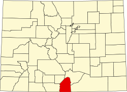 | |
| CDPs | ||
| Unincorporated communities | ||
| Ghost town | ||
Places adjacent to Costilla County, Colorado | ||||||||||||||||
|---|---|---|---|---|---|---|---|---|---|---|---|---|---|---|---|---|
| ||||||||||||||||
| International | |
|---|---|
| National | |
| Other | |