


Cardiff, New Zealand
Cardiff | |
|---|---|
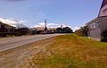
 View of Cardiff, with Mount Taranaki in the background | |
 Interactive map of Cardiff | |
| Coordinates: 39°21′38″S 174°13′52″E / 39.36056°S 174.23111°E | |
| Country | New Zealand |
| Region | Taranaki |
| District | Stratford District |
| Ward |
|
| Electorates | |
| Government | |
| • Territorial Authority | Stratford District Council |
| • Regional council | Taranaki Regional Council |
| • Mayor of Stratford | Neil Volzke[1] |
| • Whanganui MP | Carl Bates[2] |
| • Te Tai Hauāuru MP | Debbie Ngarewa-Packer[3] |
Cardiff is a settlement in inland Taranaki, in the western North Island of New Zealand. It is named after Cardiff, Wales. It is located five kilometres southwest of Stratford close to Egmont National Park.
Demographics
Cardiff locality covers 52.17 km2 (20.14 sq mi).[4] The locality is part of the Pembroke statistical area.[5]
| Year | Pop. | ±% p.a. |
|---|---|---|
| 2006 | 327 | — |
| 2013 | 330 | +0.13% |
| 2018 | 333 | +0.18% |
| 2023 | 342 | +0.53% |
| Source: [6][7] | ||
Cardiff had a population of 342 in the 2023 New Zealand census, an increase of 9 people (2.7%) since the 2018 census, and an increase of 12 people (3.6%) since the 2013 census. There were 183 males and 153 females in 126 dwellings.[8] 0.9% of people identified as LGBTIQ+. There were 78 people (22.8%) aged under 15 years, 57 (16.7%) aged 15 to 29, 165 (48.2%) aged 30 to 64, and 39 (11.4%) aged 65 or older.[6]
People could identify as more than one ethnicity. The results were 95.6% European (Pākehā); 9.6% Māori; 1.8% Pasifika; 0.9% Middle Eastern, Latin American and African New Zealanders (MELAA); and 3.5% other, which includes people giving their ethnicity as "New Zealander". English was spoken by 97.4%, and other languages by 1.8%. No language could be spoken by 1.8% (e.g. too young to talk). The percentage of people born overseas was 5.3, compared with 28.8% nationally.[6]
Religious affiliations were 23.7% Christian, 0.9% Buddhist, and 0.9% other religions. People who answered that they had no religion were 64.0%, and 10.5% of people did not answer the census question.[6]
Of those at least 15 years old, 24 (9.1%) people had a bachelor's or higher degree, 168 (63.6%) had a post-high school certificate or diploma, and 78 (29.5%) people exclusively held high school qualifications. 27 people (10.2%) earned over $100,000 compared to 12.1% nationally. The employment status of those at least 15 was 156 (59.1%) full-time, 39 (14.8%) part-time, and 3 (1.1%) unemployed.[6]
Education
Cardiff Primary School opened in 1886 and closed in 1999.[9]
Gallery
-
 Cardiff, looking south
 -
 Cardiff Hall
 -
 Cardiff, looking north


References
- ^ "Election Results". Stratford District Council. Retrieved 17 October 2025.
- ^ "Whanganui - Official Result". Electoral Commission. Retrieved 5 October 2025.
- ^ "Te Tai Hauāuru - Official Result". Retrieved 20 April 2025.
- ^ "Stats NZ Geographic Data Service". Statistical Area 1 2023 (generalised). Retrieved 6 October 2025.
- ^ "Geographic Boundary Viewer". Stats NZ. Statistical Area 1 – 2023 and Statistical Area 2 – 2023.
- ^ a b c d e "Totals by topic for individuals, (RC, TALB, UR, SA3, SA2, Ward, Health), 2013, 2018, and 2023 Censuses". Stats NZ – Tatauranga Aotearoa – Aotearoa Data Explorer. 7017304, 7017305 and 7017311. Retrieved 3 October 2024.
- ^ "Statistical area 1 dataset for 2018 Census". Statistics New Zealand. March 2020. 7017304, 7017305 and 7017311.
- ^ "Totals by topic for dwellings, (RC, TALB, UR, SA3, SA2, Ward, Health), 2013, 2018, and 2023 Censuses". Stats NZ – Tatauranga Aotearoa – Aotearoa Data Explorer. Retrieved 3 October 2024.
- ^ "Cardiff Primary School" (PDF). Stratford District Council. Retrieved 6 October 2025.
Further reading
General historical works
- Mander, Owen (1986). Cardiff School and district centennial, 1886-1986. Stratford, [N.Z.]: The School; Stratford Press Print.
Business history
- Marchant, Claude A. (1951). Cardiff Co-operative Dairy Factory Company Limited diamond jubilee, 1891 - 1951. New Plymouth, [N.Z.]: Taranaki Daily News.
- Records of the Cardiff Dairy Company Ltd (from 1891-1965 i.e. its entire history) are held at "Puke Ariki". Archived from the original on 20 June 2008. in New Plymouth. Cardiff was one of the constituent dairy co-operatives (the others being Eltham, Stratford, and Normanby) who combined to form the Taranaki Co-operative Dairy Co. Ltd. in 1965. See records of the Cardiff Dairy Company (A392) / "Cardiff Co-operative Dairy Company (ARC2001-190)". Archived from the original on 14 October 2008. Retrieved 7 February 2008.
People
- Architectural plans for a house for Cardiff resident, Fred Frethey (and dating from 1910) are held within "Puke Ariki". Archived from the original on 20 June 2008. in New Plymouth. See "Frethey Residence Cardiff (ARC2003-709)". Archived from the original on 14 October 2008. Retrieved 7 February 2008.
- An oral history resource relating to Diana Humphries (who formerly taught at Cardiff School) is held within "Puke Ariki". Archived from the original on 20 June 2008. in New Plymouth. See "Humphries, Diana (ARC2003-1152)". Archived from the original on 14 October 2008. Retrieved 7 February 2008.
- Former Stratford District mayor, David Walter, has conducted a number of oral history interviews with people within that broad geographical area. These are preserved as mp3 files on twelve CDs held within "Puke Ariki". Archived from the original on 20 June 2008. in New Plymouth. The sixth CD of this collection contains a recording of Henry Johnson speaking about his life and times, in England and Cardiff. See "David Walter Interviews Disk 6 (ARC2003-809)". Archived from the original on 14 October 2008. Retrieved 7 February 2008.
Schools
- Mander, Owen (1986). Cardiff School and district centennial, 1886-1986. Stratford, [N.Z.]: The School; Stratford Press Print.