


Alamosa County, Colorado
Alamosa County, Colorado | |
|---|---|
 Alamosa County Courthouse | |
 Location within the U.S. state of Colorado | |
| Coordinates: 37°34′N 105°47′W / 37.57°N 105.78°W | |
| Country | |
| State | |
| Founded | March 8, 1913 |
| Named after | Spanish language word for a grove of cottonwood trees |
| Seat | Alamosa |
| Largest city | Alamosa |
| Area | |
• Total | 723 sq mi (1,870 km2) |
| • Land | 723 sq mi (1,870 km2) |
| • Water | 0.7 sq mi (1.8 km2) 0.1% |
| Population (2020) | |
• Total | 16,376 |
• Estimate (2024) | 16,689 |
| • Density | 22.7/sq mi (8.75/km2) |
| Time zone | UTC−7 (Mountain) |
| • Summer (DST) | UTC−6 (MDT) |
| Congressional district | 3rd |
| Website | alamosacounty |
Alamosa County is a county located in the U.S. state of Colorado. As of the 2020 census, the population was 16,376.[1] The county seat is Alamosa.[2] The county name is the Spanish language word for a grove of cottonwood trees.
History
Alamosa County was created by the Colorado legislature on March 8, 1913, out of northwestern Costilla County.
Geography
According to the U.S. Census Bureau, the county has a total area of 723 square miles (1,870 km2), of which 723 square miles (1,870 km2) is land and 0.7 square miles (1.8 km2) (0.1%) is water.[3]
Adjacent counties
- Saguache County, Colorado - north
- Huerfano County, Colorado - east
- Costilla County, Colorado - southeast
- Conejos County, Colorado - southwest
- Rio Grande County, Colorado - west
Major highways
 U.S. Highway 160
 U.S. Highway 285
 State Highway 17
 State Highway 150
 State Highway 368
 State Highway 370
 State Highway 371
National protected area
Other protected areas
- Alamosa National Wildlife Refuge
- Great Sand Dunes Wilderness
- Monte Vista National Wildlife Refuge
- Rio Grande National Forest
- San Luis Lakes State Wildlife Area
- Sangre de Cristo Wilderness
Scenic trails
Transportation
Alamosa is served by San Luis Valley Regional Airport. The only commercial service is to Denver.
Demographics
| Census | Pop. | Note | %± |
|---|---|---|---|
| 1920 | 5,148 | — | |
| 1930 | 8,602 | 67.1% | |
| 1940 | 10,484 | 21.9% | |
| 1950 | 10,531 | 0.4% | |
| 1960 | 10,000 | −5.0% | |
| 1970 | 11,422 | 14.2% | |
| 1980 | 11,799 | 3.3% | |
| 1990 | 13,617 | 15.4% | |
| 2000 | 14,966 | 9.9% | |
| 2010 | 15,445 | 3.2% | |
| 2020 | 16,376 | 6.0% | |
| 2024 (est.) | 16,689 | [4] | 1.9% |
| U.S. Decennial Census[5] 1790-1960[6] 1900-1990[7] 1990-2000[8] 2010-2020[1] | |||
2020 census
As of the 2020 census, the county had a population of 16,376. Of the residents, 23.4% were under the age of 18 and 16.2% were 65 years of age or older; the median age was 35.0 years. For every 100 females there were 96.0 males, and for every 100 females age 18 and over there were 93.1 males. 67.0% of residents lived in urban areas and 33.0% lived in rural areas.[9][10][11]
| Race / Ethnicity (NH = Non-Hispanic) | Pop 2000[12] | Pop 2010[13] | Pop 2020[14] | % 2000 | % 2010 | % 2020 |
|---|---|---|---|---|---|---|
| White alone (NH) | 8,089 | 7,667 | 7,490 | 54.05% | 49.64% | 45.74% |
| Black or African American alone (NH) | 106 | 138 | 211 | 0.71% | 0.89% | 1.29% |
| Native American or Alaska Native alone (NH) | 186 | 134 | 215 | 1.24% | 0.87% | 1.31% |
| Asian alone (NH) | 112 | 130 | 142 | 0.75% | 0.84% | 0.87% |
| Pacific Islander alone (NH) | 12 | 6 | 19 | 0.08% | 0.04% | 0.12% |
| Other race alone (NH) | 38 | 33 | 104 | 0.25% | 0.21% | 0.64% |
| Mixed race or Multiracial (NH) | 226 | 227 | 494 | 1.51% | 1.47% | 3.02% |
| Hispanic or Latino (any race) | 6,197 | 7,110 | 7,701 | 41.41% | 46.03% | 47.03% |
| Total | 14,966 | 15,445 | 16,376 | 100.00% | 100.00% | 100.00% |
The racial makeup of the county was 61.5% White, 1.5% Black or African American, 4.3% American Indian and Alaska Native, 1.1% Asian, 0.1% Native Hawaiian and Pacific Islander, 13.7% from some other race, and 17.7% from two or more races. Hispanic or Latino residents of any race comprised 47.0% of the population.[11]
There were 6,377 households in the county, of which 30.1% had children under the age of 18 living with them and 30.2% had a female householder with no spouse or partner present. About 32.5% of all households were made up of individuals and 12.0% had someone living alone who was 65 years of age or older.[10]
There were 7,064 housing units, of which 9.7% were vacant. Among occupied housing units, 58.0% were owner-occupied and 42.0% were renter-occupied. The homeowner vacancy rate was 1.7% and the rental vacancy rate was 7.9%.[10]
2000 census
At the 2000 census there were 14,966 people, 5,467 households, and 3,651 families living in the county. The population density was 21 people per square mile (8.1 people/km2). There were 6,088 housing units at an average density of 8 per square mile (3.1/km2). The racial makeup of the county was 71.19% White, 0.97% Black or African American, 2.34% Native American, 0.82% Asian, 0.19% Pacific Islander, 20.34% from other races, and 4.16% from two or more races. 41.41% of the population were Hispanic or Latino of any race.[15] Of the 5,467 households 35.30% had children under the age of 18 living with them, 50.50% were married couples living together, 11.70% had a female householder with no husband present, and 33.20% were non-families. 27.30% of households were one person and 8.70% were one person aged 65 or older. The average household size was 2.56 and the average family size was 3.14.
The age distribution was 27.20% under the age of 18, 15.90% from 18 to 24, 26.70% from 25 to 44, 20.60% from 45 to 64, and 9.60% 65 or older. The median age was 31 years. For every 100 females there were 99.00 males. For every 100 females age 18 and over, there were 95.30 males.
The median household income was $29,447 and the median family income was $38,389. Males had a median income of $27,733 versus $22,806 for females. The per capita income for the county was $15,037. About 15.60% of families and 21.30% of the population were below the poverty line, including 27.40% of those under age 18 and 13.90% of those age 65 or over.
In 2000, the largest denominational groups were Catholics (with 5,716 members) and Evangelical Protestants (with 1,755 members).[16] The largest religious bodies were the Catholic Church (with 5,716 adherents) and the Church of Jesus Christ of Latter-day Saints (with 1,155 adherents).[16]
Politics
| Year | Republican | Democratic | Third party(ies) | |||
|---|---|---|---|---|---|---|
| No. | % | No. | % | No. | % | |
| 1916 | 488 | 26.15% | 1,308 | 70.10% | 70 | 3.75% |
| 1920 | 1,081 | 51.87% | 949 | 45.54% | 54 | 2.59% |
| 1924 | 1,009 | 40.59% | 625 | 25.14% | 852 | 34.27% |
| 1928 | 1,759 | 58.23% | 1,239 | 41.01% | 23 | 0.76% |
| 1932 | 1,306 | 36.96% | 2,141 | 60.58% | 87 | 2.46% |
| 1936 | 1,188 | 29.71% | 2,754 | 68.87% | 57 | 1.43% |
| 1940 | 2,243 | 47.39% | 2,467 | 52.12% | 23 | 0.49% |
| 1944 | 1,933 | 51.56% | 1,806 | 48.17% | 10 | 0.27% |
| 1948 | 1,950 | 44.58% | 2,395 | 54.76% | 29 | 0.66% |
| 1952 | 2,728 | 62.13% | 1,626 | 37.03% | 37 | 0.84% |
| 1956 | 2,442 | 62.33% | 1,465 | 37.39% | 11 | 0.28% |
| 1960 | 2,271 | 55.58% | 1,811 | 44.32% | 4 | 0.10% |
| 1964 | 1,488 | 37.42% | 2,481 | 62.40% | 7 | 0.18% |
| 1968 | 2,277 | 55.00% | 1,574 | 38.02% | 289 | 6.98% |
| 1972 | 2,916 | 62.51% | 1,540 | 33.01% | 209 | 4.48% |
| 1976 | 2,599 | 53.51% | 2,052 | 42.25% | 206 | 4.24% |
| 1980 | 2,601 | 53.87% | 1,821 | 37.72% | 406 | 8.41% |
| 1984 | 2,953 | 62.68% | 1,720 | 36.51% | 38 | 0.81% |
| 1988 | 2,567 | 53.70% | 2,146 | 44.90% | 67 | 1.40% |
| 1992 | 1,572 | 34.05% | 1,928 | 41.76% | 1,117 | 24.19% |
| 1996 | 2,038 | 41.23% | 2,330 | 47.14% | 575 | 11.63% |
| 2000 | 2,857 | 50.49% | 2,455 | 43.38% | 347 | 6.13% |
| 2004 | 3,179 | 50.63% | 3,017 | 48.05% | 83 | 1.32% |
| 2008 | 2,635 | 41.92% | 3,521 | 56.01% | 130 | 2.07% |
| 2012 | 2,705 | 40.28% | 3,811 | 56.75% | 199 | 2.96% |
| 2016 | 3,046 | 43.90% | 3,189 | 45.96% | 704 | 10.15% |
| 2020 | 3,813 | 48.83% | 3,759 | 48.14% | 236 | 3.02% |
| 2024 | 4,057 | 53.88% | 3,244 | 43.09% | 228 | 3.03% |
Alamosa County is a competitive swing county, voting for the winning presidential candidate in every election since its formation except 1944, 1960, 1976, 2016, and 2020.
Communities
City
Town
Census-designated place
Unincorporated communities
Sheriff's Office
| Alamosa County Sheriff's Office | |
|---|---|
| Agency overview | |
| Preceding agency |
|
| Employees | 39 |
| Jurisdictional structure | |
| Operations jurisdiction | Alamosa County, Colorado, U.S. |
| Population | 16376 |
| General nature | |
| Operational structure | |
| Headquarters | 1315 17th Street Alamosa, Colorado 81101 |
| Sworn members | 18 |
| Unsworn members | 21 |
| Agency executive |
|
| Website | |
| https://www.alamosacounty.org | |
The Alamosa County Sheriff's Office is a county law enforcement agency in Alamosa County, Colorado, United States.[18] It consists of 18 sworn law enforcement officers and 21 civilian support personnel.[19]
Rank structure
| Title | Insignia |
|---|---|
| Sheriff |  |
| Undersheriff |  |
| Sergeant | .svg) |
| Corporal | .svg) |
| Deputy |
License plate code
Alamosa County has used the following county codes on Colorado license plates issued to passenger vehicles in the county: XE-XG and EAA-ABD.[20]
See also
- Bibliography of Colorado
- Geography of Colorado
- History of Colorado
- Index of Colorado-related articles
- List of Colorado-related lists
- Outline of Colorado
References
- ^ a b "U.S. Census Bureau QuickFacts". U.S. Census Bureau. Retrieved September 4, 2021.
- ^ "Find a County". National Association of Counties. Archived from the original on May 31, 2011. Retrieved June 7, 2011.
- ^ "US Gazetteer files: 2010, 2000, and 1990". United States Census Bureau. February 12, 2011. Retrieved April 23, 2011.
- ^ "County Population Totals and Components of Change: 2020-2024". United States Census Bureau. Retrieved May 21, 2025.
- ^ "U.S. Decennial Census". United States Census Bureau. Retrieved June 7, 2014.
- ^ "Historical Census Browser". University of Virginia Library. Retrieved June 7, 2014.
- ^ "Population of Counties by Decennial Census: 1900 to 1990". United States Census Bureau. Retrieved June 7, 2014.
- ^ "Census 2000 PHC-T-4. Ranking Tables for Counties: 1990 and 2000" (PDF). United States Census Bureau. Archived (PDF) from the original on March 27, 2010. Retrieved June 7, 2014.
- ^ "2020 Decennial Census Demographic and Housing Characteristics (DHC)". United States Census Bureau. 2023. Retrieved 2025-12-08.
- ^ a b c "2020 Decennial Census Demographic Profile (DP1)". United States Census Bureau. 2021. Retrieved 2025-12-08.
- ^ a b "2020 Decennial Census Redistricting Data (Public Law 94-171)". United States Census Bureau. 2021. Retrieved 2025-12-08.
- ^ "P004: Hispanic or Latino, and Not Hispanic or Latino by Race – 2000: DEC Summary File 1 – Alamosa County, Colorado". United States Census Bureau. Retrieved February 5, 2026.
- ^ "P2 Hispanic or Latino, and Not Hispanic or Latino by Race – 2010: DEC Redistricting Data (PL 94-171) - Alamosa County, Colorado". United States Census Bureau. Retrieved February 5, 2026.
- ^ "P2 Hispanic or Latino, and Not Hispanic or Latino by Race – 2020: DEC Redistricting Data (PL 94-171) - Alamosa County, Colorado". United States Census Bureau. Retrieved February 5, 2026.
- ^ "U.S. Census website". United States Census Bureau. Retrieved May 14, 2011.
- ^ a b "County Membership Reports". thearda.com. Archived from the original on July 12, 2011. Retrieved August 22, 2011.
- ^ "Dave Leip's Atlas of U.S. Presidential Elections". Retrieved June 11, 2011.
- ^ "Alamosa County Sheriff's Office in Alamosa, Colorado".
- ^ "Alamosa County Sheriffs Office / Alamosa County Jail - Alamosa, CO (Address, Phone, and Fax)".
- ^ Colorado County Codes
External links
- State of Colorado
- Official website
- Colorado County Evolution by Don Stanwyck
- Official page at Facebook
Municipalities and communities of Alamosa County, Colorado, United States | ||
|---|---|---|
| City | 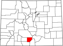 | |
| Town | ||
| CDP | ||
| Unincorporated communities | ||
| Footnotes | ‡This populated place also has portions in an adjacent county or counties | |
Places adjacent to Alamosa County, Colorado | ||||||||||||||||
|---|---|---|---|---|---|---|---|---|---|---|---|---|---|---|---|---|
| ||||||||||||||||
| International | |
|---|---|
| National | |
| Other | |