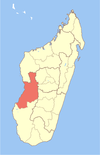
Morondava District is a district in the Menabe region in eastern Madagascar.[2][3] Its capital is Morondava. The district has an area of 5,691 km2 (2,197 sq mi), and the estimated population in 2020 was 157,596.[4]
Municipalities
The district is further divided into six municipalities:
Roads
- RN 34 to Ivato, Ambositra and Antsirabe.
- RN 8 to Belo-sur-Tsiribihina.
Airports
Rivers
Nature
- Tsingy de Bemaraha Strict Nature Reserve
- Andranomena Reserve
- Kirindy Forest
- Avenue of the Baobabs, 20 km north of Morondava.
Religion
- Roman Catholic Diocese (Cathedral of Mary Queen of the World).
- Fiangonana Jesosy Mamonjy Morondava
- FJKM - Fiangonan'i Jesoa Kristy eto Madagasikara (Church of Jesus Christ in Madagascar)
See also
- Betania, a beach village in Morondava district.
References
- ^ Morondava autrement
- ^ REPOBLIKAN'I MADAGASIKARA:Tanindrazana – Fahafahana – Fandrosoana (PDF). MINISTERE DE L’AGRICULTURE, DE L’ELEVAGE ET DE LA PECHE. October 2007. pp. 42–44. Archived from the original (PDF) on 2018-06-12. Retrieved 2018-06-09.
- ^ "Madagascar: Administrative Division". citypopulation. Retrieved 10 June 2018.
- ^ "Madagascar: Administrative Division". citypopulation. Retrieved 10 June 2018.


