


Size of this preview: 613 × 599 pixels. Other resolutions: 245 × 240 pixels | 491 × 480 pixels | 762 × 745 pixels.
Original file (762 × 745 pixels, file size: 769 KB, MIME type: image/png)
Summary
| Description |
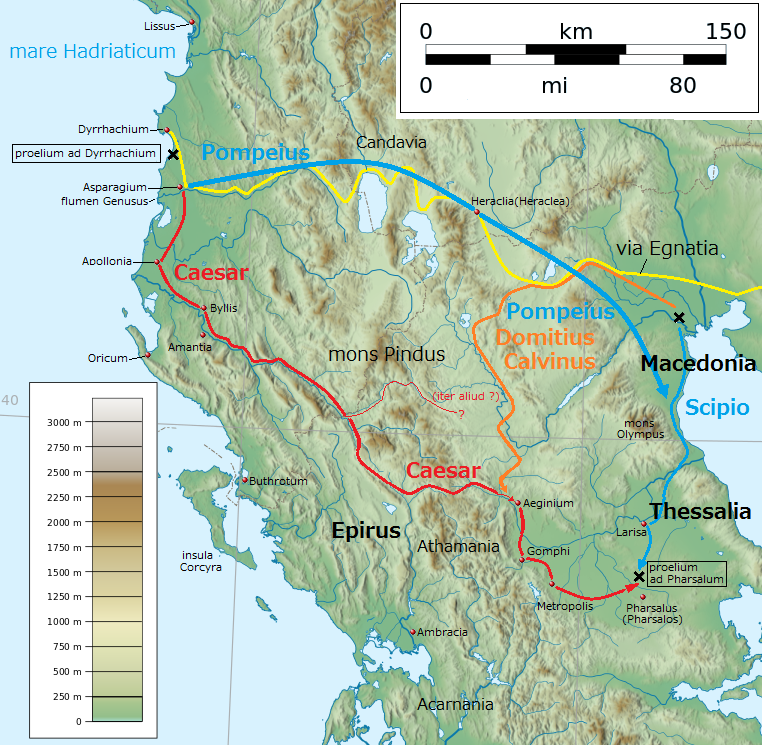
English: Map of Ancient Greece for Caesar's Civil War in 48 BC (by Latin language)
日本語: ローマ内戦(BC48年)における古代ギリシアの地図(ラテン語) |
| Date | |
| Source | Own work + based on File:Greece large topographic basemap.svg |
| Author | Linguae |
| Other versions | Japanese version, blank version |
.png)
.png)
Licensing
I, the copyright holder of this work, hereby publish it under the following license:
This file is licensed under the Creative Commons Attribution-Share Alike 4.0 International license.
- You are free:
- to share – to copy, distribute and transmit the work
- to remix – to adapt the work
- Under the following conditions:
- attribution – You must give appropriate credit, provide a link to the license, and indicate if changes were made. You may do so in any reasonable manner, but not in any way that suggests the licensor endorses you or your use.
- share alike – If you remix, transform, or build upon the material, you must distribute your contributions under the same or compatible license as the original.
File history
Click on a date/time to view the file as it appeared at that time.
| Date/Time | Thumbnail | Dimensions | User | Comment | |
|---|---|---|---|---|---|
| current | 20:06, 14 January 2017 | | 762 × 745 (769 KB) | Linguae | User created page with UploadWizard |
File usage
The following 4 pages use this file:
Global file usage
The following other wikis use this file:
- Usage on he.wikipedia.org
- Usage on hy.wikipedia.org
.png)