


Size of this PNG preview of this SVG file: 470 × 599 pixels. Other resolutions: 188 × 240 pixels | 377 × 480 pixels | 603 × 768 pixels | 803 × 1,024 pixels | 1,607 × 2,048 pixels | 1,024 × 1,305 pixels.
Original file (SVG file, nominally 1,024 × 1,305 pixels, file size: 1.03 MB)
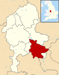
| Description | Map of Staffordshire, with Lichfield highlighted. |
| Date | (UTC) |
| Source | |
| Author |
|
.svg)
I, the copyright holder of this work, hereby publish it under the following license:
This file is licensed under the Creative Commons Attribution-Share Alike 3.0 Unported license.
- You are free:
- to share – to copy, distribute and transmit the work
- to remix – to adapt the work
- Under the following conditions:
- attribution – You must give appropriate credit, provide a link to the license, and indicate if changes were made. You may do so in any reasonable manner, but not in any way that suggests the licensor endorses you or your use.
- share alike – If you remix, transform, or build upon the material, you must distribute your contributions under the same or compatible license as the original.
Original upload log
This image is a derivative work of the following images:
- File:Staffordshire UK district map (blank).svg licensed with Cc-by-sa-3.0
- 2010-08-22T08:19:06Z Nilfanion 1024x1305 (1081109 Bytes) +inset, water colour tweak
- 2010-07-16T23:54:44Z Nilfanion 1024x1305 (711394 Bytes) {{Information |Description=Map of [[w:Staffordshire|Staffordshire]], UK with districts shown. Equirectangular map projection on WGS 84 datum, with N/S stretched 165% Geographic limits: *West: 2.50W *East: 1.40W *North: 53.2
File history
Click on a date/time to view the file as it appeared at that time.
| Date/Time | Thumbnail | Dimensions | User | Comment | |
|---|---|---|---|---|---|
| current | 20:42, 12 August 2011 | | 1,024 × 1,305 (1.03 MB) | Renly~commonswiki | {{Information |Description=Map of Staffordshire, with Lichfield highlighted. |Source=*Staffordshire UK district map (blank).svg |Date=2011-08-12 20:42 (UTC) |Author=*[[:File:Staffordshire UK district map |
.svg)
File usage
The following 2 pages use this file:
Global file usage
The following other wikis use this file:
- Usage on cy.wikipedia.org
- Usage on es.wikipedia.org
- Usage on fa.wikipedia.org
- Usage on ja.wikipedia.org
- Usage on ko.wikipedia.org
- Usage on lv.wikipedia.org
- Usage on nl.wikipedia.org
- Usage on pl.wikipedia.org
- Usage on ru.wikipedia.org
- Usage on sv.wikipedia.org
- Usage on ur.wikipedia.org
- Usage on www.wikidata.org
- Usage on zh-min-nan.wikipedia.org