


No higher resolution available.
Kingsferry_Bridge_-_geograph.org.uk_-_4251.jpg (640 × 471 pixels, file size: 55 KB, MIME type: image/jpeg)
Summary
| Description |
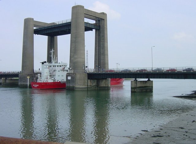
English: Kingsferry Bridge |
| Date | |
| Source | From geograph.org.uk |
| Author | Penny Mayes |
| Permission (Reusing this file) |
Creative Commons Attribution Share-alike license 2.0 |
| Camera location | | View this and other nearby images on: OpenStreetMap |
|---|
Licensing

|
This image was taken from the Geograph project collection. See this photograph's page on the Geograph website for the photographer's contact details. The copyright on this image is owned by Penny Mayes and is licensed for reuse under the Creative Commons Attribution-ShareAlike 2.0 license.
|
This file is licensed under the Creative Commons Attribution-Share Alike 2.0 Generic license.
Attribution: Penny Mayes
- You are free:
- to share – to copy, distribute and transmit the work
- to remix – to adapt the work
- Under the following conditions:
- attribution – You must give appropriate credit, provide a link to the license, and indicate if changes were made. You may do so in any reasonable manner, but not in any way that suggests the licensor endorses you or your use.
- share alike – If you remix, transform, or build upon the material, you must distribute your contributions under the same or compatible license as the original.
File history
Click on a date/time to view the file as it appeared at that time.
| Date/Time | Thumbnail | Dimensions | User | Comment | |
|---|---|---|---|---|---|
| current | 20:23, 21 October 2006 | | 640 × 471 (55 KB) | Regan123~commonswiki | {{geograph|TQ9169|Penny Mayes}} Kingsferry Bridge - This lifting bridge was built in 1960, the third in a succession of bridges linking the Isle of Sheppey to the mainland. The bridge is owned by the railway - both rail and road traffic are halted by the |
File usage
The following 3 pages use this file:
Global file usage
The following other wikis use this file:
- Usage on en.wiktionary.org
- Usage on nn.wikipedia.org
- Usage on no.wikipedia.org
- Usage on zh.wikipedia.org