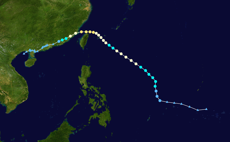
WP232004,               AERE,     54,
20040817, 1800,  , DB,  9.4N, 146.5E,  20,     ,    0,    0,    0,    0,    0,    0,    0,    0,    0,    0,    0,    0,    JTWC,
20040818, 0000,  , DB,  9.2N, 144.7E,  20,     ,    0,    0,    0,    0,    0,    0,    0,    0,    0,    0,    0,    0,    JTWC,
20040818, 0600,  , DB,  9.9N, 143.0E,  20,     ,    0,    0,    0,    0,    0,    0,    0,    0,    0,    0,    0,    0,    JTWC,
20040818, 1200,  , DB, 10.5N, 141.3E,  20,     ,    0,    0,    0,    0,    0,    0,    0,    0,    0,    0,    0,    0,    JTWC,
20040818, 1800,  , DB, 10.7N, 139.8E,  20,     ,    0,    0,    0,    0,    0,    0,    0,    0,    0,    0,    0,    0,    JTWC,
20040819, 0000,  , DB, 10.9N, 138.3E,  25,     ,    0,    0,    0,    0,    0,    0,    0,    0,    0,    0,    0,    0,    JTWC,
20040819, 0600,  , TD, 11.2N, 136.8E,  25,     ,    0,    0,    0,    0,    0,    0,    0,    0,    0,    0,    0,    0,    JTWC,
20040819, 1200,  , TD, 12.1N, 136.2E,  25,     ,    0,    0,    0,    0,    0,    0,    0,    0,    0,    0,    0,    0,    JTWC,
20040819, 1800,  , TD, 13.2N, 136.0E,  30,     ,    0,    0,    0,    0,    0,    0,    0,    0,    0,    0,    0,    0,    JTWC,
20040820, 0000,  , TS, 14.2N, 135.8E,  35,     ,    0,    0,    0,    0,    0,    0,    0,    0,    0,    0,    0,    0,    JTWC,
20040820, 0600,  , TS, 15.2N, 135.9E,  40,     ,    0,    0,    0,    0,    0,    0,    0,    0,    0,    0,    0,    0,    JTWC,
20040820, 1200,  , TS, 16.0N, 135.3E,  45,     ,    0,    0,    0,    0,    0,    0,    0,    0,    0,    0,    0,    0,    JTWC,
20040820, 1800,  , TS, 16.7N, 134.5E,  50,     ,    0,    0,    0,    0,    0,    0,    0,    0,    0,    0,    0,    0,    JTWC,
20040821, 0000,  , TS, 17.5N, 133.8E,  55,     ,    0,    0,    0,    0,    0,    0,    0,    0,    0,    0,    0,    0,    JTWC,
20040821, 0600,  , TS, 18.2N, 132.8E,  55,     ,    0,    0,    0,    0,    0,    0,    0,    0,    0,    0,    0,    0,    JTWC,
20040821, 1200,  , TY, 18.9N, 131.8E,  65,     ,    0,    0,    0,    0,    0,    0,    0,    0,    0,    0,    0,    0,    JTWC,
20040821, 1800,  , TY, 19.6N, 130.8E,  65,     ,    0,    0,    0,    0,    0,    0,    0,    0,    0,    0,    0,    0,    JTWC,
20040822, 0000,  , TY, 20.3N, 129.7E,  65,     ,    0,    0,    0,    0,    0,    0,    0,    0,    0,    0,    0,    0,    JTWC,
20040822, 0600,  , TY, 21.0N, 128.7E,  65,     ,    0,    0,    0,    0,    0,    0,    0,    0,    0,    0,    0,    0,    JTWC,
20040822, 1200,  , TY, 21.6N, 127.8E,  65,     ,    0,    0,    0,    0,    0,    0,    0,    0,    0,    0,    0,    0,    JTWC,
20040822, 1800,  , TS, 22.2N, 127.0E,  55,     ,    0,    0,    0,    0,    0,    0,    0,    0,    0,    0,    0,    0,    JTWC,
20040823, 0000,  , TS, 22.8N, 126.2E,  60,     ,    0,    0,    0,    0,    0,    0,    0,    0,    0,    0,    0,    0,    JTWC,
20040823, 0600,  , TY, 23.3N, 125.5E,  65,     ,    0,    0,    0,    0,    0,    0,    0,    0,    0,    0,    0,    0,    JTWC,
20040823, 1200,  , TY, 23.8N, 125.0E,  70,     ,    0,    0,    0,    0,    0,    0,    0,    0,    0,    0,    0,    0,    JTWC,
20040823, 1800,  , TY, 24.4N, 124.5E,  75,     ,    0,    0,    0,    0,    0,    0,    0,    0,    0,    0,    0,    0,    JTWC,
20040824, 0000,  , TY, 24.9N, 124.0E,  80,     ,    0,    0,    0,    0,    0,    0,    0,    0,    0,    0,    0,    0,    JTWC,
20040824, 0600,  , TY, 25.3N, 123.5E,  80,     ,    0,    0,    0,    0,    0,    0,    0,    0,    0,    0,    0,    0,    JTWC,
20040824, 1200,  , TY, 25.5N, 122.9E,  85,     ,    0,    0,    0,    0,    0,    0,    0,    0,    0,    0,    0,    0,    JTWC,
20040824, 1800,  , TY, 25.6N, 122.2E,  90,     ,    0,    0,    0,    0,    0,    0,    0,    0,    0,    0,    0,    0,    JTWC,
20040825, 0000,  , TY, 25.6N, 121.4E,  90,     ,    0,    0,    0,    0,    0,    0,    0,    0,    0,    0,    0,    0,    JTWC,
20040825, 0600,  , TY, 25.6N, 120.4E,  85,     ,    0,    0,    0,    0,    0,    0,    0,    0,    0,    0,    0,    0,    JTWC,
20040825, 1200,  , TY, 25.3N, 119.2E,  75,     ,    0,    0,    0,    0,    0,    0,    0,    0,    0,    0,    0,    0,    JTWC,
20040825, 1800,  , TY, 24.7N, 118.1E,  65,     ,    0,    0,    0,    0,    0,    0,    0,    0,    0,    0,    0,    0,    JTWC,
20040826, 0000,  , TS, 24.2N, 117.2E,  60,     ,    0,    0,    0,    0,    0,    0,    0,    0,    0,    0,    0,    0,    JTWC,
20040826, 0600,  , TS, 23.9N, 116.4E,  40,     ,    0,    0,    0,    0,    0,    0,    0,    0,    0,    0,    0,    0,    JTWC,
20040826, 1200,  , TD, 23.6N, 115.7E,  30,     ,    0,    0,    0,    0,    0,    0,    0,    0,    0,    0,    0,    0,     JMA,
20040826, 1800,  , DB, 23.0N, 114.5E,  25,     ,    0,    0,    0,    0,    0,    0,    0,    0,    0,    0,    0,    0,     JMA,
20040827, 0000,  , DB, 22.8N, 113.3E,  25,     ,    0,    0,    0,    0,    0,    0,    0,    0,    0,    0,    0,    0,     JMA,
20040827, 0600,  , DB, 22.7N, 113.1E,  25,     ,    0,    0,    0,    0,    0,    0,    0,    0,    0,    0,    0,    0,     JMA,
20040827, 1200,  , DB, 22.6N, 112.9E,  25,     ,    0,    0,    0,    0,    0,    0,    0,    0,    0,    0,    0,    0,     JMA,
20040827, 1800,  , DB, 22.5N, 112.6E,  25,     ,    0,    0,    0,    0,    0,    0,    0,    0,    0,    0,    0,    0,     JMA,
20040828, 0000,  , DB, 22.4N, 112.3E,  25,     ,    0,    0,    0,    0,    0,    0,    0,    0,    0,    0,    0,    0,     JMA,
20040828, 0600,  , DB, 22.2N, 112.2E,  25,     ,    0,    0,    0,    0,    0,    0,    0,    0,    0,    0,    0,    0,     JMA,
20040828, 1200,  , DB, 21.5N, 111.2E,  25,     ,    0,    0,    0,    0,    0,    0,    0,    0,    0,    0,    0,    0,     JMA,
20040828, 1800,  , DB, 21.4N, 110.7E,  25,     ,    0,    0,    0,    0,    0,    0,    0,    0,    0,    0,    0,    0,     JMA,
20040829, 0000,  , DB, 21.6N, 110.6E,  25,     ,    0,    0,    0,    0,    0,    0,    0,    0,    0,    0,    0,    0,     JMA,
20040829, 0600,  , DB, 21.7N, 110.6E,  25,     ,    0,    0,    0,    0,    0,    0,    0,    0,    0,    0,    0,    0,     JMA,
20040829, 1200,  , DB, 21.7N, 110.1E,  25,     ,    0,    0,    0,    0,    0,    0,    0,    0,    0,    0,    0,    0,     JMA,
20040829, 1800,  , DB, 21.6N, 109.7E,  25,     ,    0,    0,    0,    0,    0,    0,    0,    0,    0,    0,    0,    0,     JMA,
20040830, 0000,  , DB, 21.6N, 109.7E,  25,     ,    0,    0,    0,    0,    0,    0,    0,    0,    0,    0,    0,    0,     JMA,
20040830, 0600,  , DB, 21.8N, 109.7E,  25,     ,    0,    0,    0,    0,    0,    0,    0,    0,    0,    0,    0,    0,     JMA,
20040830, 1200,  , DB, 21.8N, 109.6E,  25,     ,    0,    0,    0,    0,    0,    0,    0,    0,    0,    0,    0,    0,     JMA,
20040830, 1800,  , DB, 21.4N, 108.9E,  25,     ,    0,    0,    0,    0,    0,    0,    0,    0,    0,    0,    0,    0,     JMA,
20040831, 0000,  , DB, 21.0N, 108.4E,  25,     ,    0,    0,    0,    0,    0,    0,    0,    0,    0,    0,    0,    0,     JMA,


