


File:View of Pillaton Old Hall (Geograph 398695 by Geoff Pick).jpg
No higher resolution available.
View_of_Pillaton_Old_Hall_(Geograph_398695_by_Geoff_Pick).jpg (640 × 480 pixels, file size: 80 KB, MIME type: image/jpeg)
| Description |
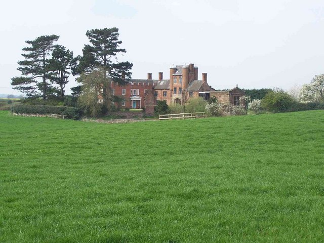
English: View of Pillaton Old Hall, home of the Littleton family, near Penkridge, Staffordshire. The moated manor eventually became a ruin, but the gatehouse and chapel were restored in the 1880s by Lord Hatherton. |
||||||||||||||||
| Date | |||||||||||||||||
| Source | geograph.org | ||||||||||||||||
| Author | Geoff Pick | ||||||||||||||||
| Permission (Reusing this file) |
== Summary ==
This file is licensed under the Creative Commons Attribution-Share Alike 2.0 Generic license. Attribution: Geoff Pick
|

.jpg¶ms=052.713550_N_-002.084184_E_globe:Earth_type:camera_heading:270.00&language=en)
File history
Click on a date/time to view the file as it appeared at that time.
| Date/Time | Thumbnail | Dimensions | User | Comment | |
|---|---|---|---|---|---|
| current | 00:34, 8 July 2010 | | 640 × 480 (80 KB) | MarmadukePercy | {{Information |Description={{en|1=View of Pillaton Old Hall, home of the Littleton family, near Penkridge, Staffordshire. The moated manor eventually became a ruin, but the gatehouse and chapel were restored in the 1880s by Lord Hatherton.}} |Source=geogr |
File usage
The following 11 pages use this file:
- Edward Littleton (died 1558)
- Edward Littleton (died 1610)
- Edward Littleton (died 1629)
- Grade II* listed buildings in South Staffordshire
- Littleton baronets
- Lyttelton family
- Pillaton Hall
- Sir Edward Littleton, 1st Baronet
- Sir Edward Littleton, 2nd Baronet
- Sir Edward Littleton, 4th Baronet
- Wikipedia:WikiProject Historic sites/Images of listed buildings in England without ID
Global file usage
The following other wikis use this file:
- Usage on pt.wikipedia.org
- Usage on www.wikidata.org
.jpg)