


File:European Union OCTs Locator.png

Size of this preview: 800 × 383 pixels. Other resolutions: 320 × 153 pixels | 640 × 306 pixels | 1,024 × 490 pixels | 1,280 × 612 pixels | 2,420 × 1,158 pixels.
Original file (2,420 × 1,158 pixels, file size: 165 KB, MIME type: image/png)

|
File:EU EEZ.svg is a vector version of this file. It should be used in place of this PNG file when not inferior.
File:European Union OCTs Locator.png → File:EU EEZ.svg
For more information, see Help:SVG. |
 |
Summary
| Description |
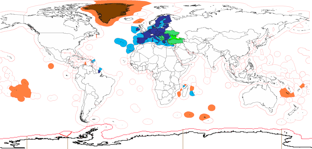
English: EU
enlargement agenda
member state special territories outside EU |
| Date | |
| Source | Own work (Original text: I (Alinor (talk)) created this work entirely by myself.) |
| Author | Alinor at English Wikipedia |

|
This economic map image could be re-created using vector graphics as an SVG file. This has several advantages; see Commons:Media for cleanup for more information. If an SVG form of this image is available, please upload it and afterwards replace this template with
{{vector version available|new image name}}.It is recommended to name the SVG file “European Union OCTs Locator.svg”—then the template Vector version available (or Vva) does not need the new image name parameter. |
Licensing
Alinor at English Wikipedia, the copyright holder of this work, hereby publishes it under the following licenses:
This file is licensed under the Creative Commons Attribution-Share Alike 3.0 Unported license.
Attribution:
- You are free:
- to share – to copy, distribute and transmit the work
- to remix – to adapt the work
- Under the following conditions:
- attribution – You must give appropriate credit, provide a link to the license, and indicate if changes were made. You may do so in any reasonable manner, but not in any way that suggests the licensor endorses you or your use.
- share alike – If you remix, transform, or build upon the material, you must distribute your contributions under the same or compatible license as the original.

|
Permission is granted to copy, distribute and/or modify this document under the terms of the GNU Free Documentation License, Version 1.2 or any later version published by the Free Software Foundation; with no Invariant Sections, no Front-Cover Texts, and no Back-Cover Texts. A copy of the license is included in the section entitled GNU Free Documentation License. |
You may select the license of your choice.
Original upload log
Transferred from en.wikipedia to Commons by SreeBot.
The original description page was here. All following user names refer to en.wikipedia.
Upload date | User | Bytes | Dimensions | Comment
- 2010-12-24 09:10 (UTC) | Alinor | 206750 (bytes) | 2420×1292 | see talk
- 2010-10-31 06:57 (UTC) | Alinor | 206759 (bytes) | 2420×1292 | CH fix
- 2010-07-22 15:45 (UTC) | Alinor | 206778 (bytes) | 2420×1292 | {{Information |Description = blue-EU, green-enlargement agenda, orange-EU member state special territories outside EU |Source = I (~~~) created this work entirely by myself. |Date = ~~~~~ |Author = ~~~ |other_versions =
File history
Click on a date/time to view the file as it appeared at that time.
| Date/Time | Thumbnail | Dimensions | User | Comment | |
|---|---|---|---|---|---|
| current | 15:41, 2 July 2022 | | 2,420 × 1,158 (165 KB) | Salvan Lorand | Ukraine, Moldova and Georgia are all 3 on the enlargement agenda now, Moldova and Ukraine har already receiverd candidate status too |
| 15:39, 2 February 2020 |  | 2,420 × 1,158 (165 KB) | Heitordp | Removed UK, British territories and Iceland; adjusted Cyprus, Switzerland and Clipperton; reduced white space on top | |
| 22:23, 15 June 2019 |  | 2,420 × 1,292 (115 KB) | Jurryaany | Minor fixes, removed Northern Cyprus from pending status and colored Mayotte blue as it is a full member territory | |
| 12:09, 5 January 2016 |  | 2,420 × 1,292 (167 KB) | Chocofrito | According to the Antarctic Treaty, no country can have any territory in Antarctica. | |
| 11:22, 30 June 2013 |  | 2,420 × 1,292 (225 KB) | U5K0 | croatia | |
| 10:47, 16 November 2011 |  | 2,420 × 1,292 (202 KB) | SreeBot | (Original text) : see talk | |
| 10:46, 16 November 2011 |  | 2,420 × 1,292 (202 KB) | SreeBot | (Original text) : CH fix | |
| 10:46, 16 November 2011 |  | 2,420 × 1,292 (202 KB) | SreeBot | (Original text) : {{Information |Description = blue-EU, green-enlargement agenda, orange-EU member state special territories outside EU |Source = I (~~~) created this work entirely by myself. |Date = ~~~~~ |Author = ~~~ | |
File usage
The following 4 pages use this file:
Global file usage
The following other wikis use this file:
- Usage on el.wikipedia.org
- Usage on sl.wikipedia.org
- Usage on uk.wikipedia.org