


Route 299 is a 137-kilometre (85 mi) long two-lane highway which cuts through the Appalachian Mountains in Quebec, Canada. It starts at the junction of Route 132 in Cascapédia–Saint-Jules, runs through Gaspésie National Park and ends at the junction of Route 132 in Sainte-Anne-des-Monts. It is an isolated highway with only a few small settlements along the way.
Municipalities along Route 299
-
 Route 299 near Mount Albert during winter.
 -
 Route 299 towards Chic-Chocs mountains.
 -
 Route 299 entering Gaspésie National Park.
 -
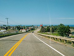 Route 299 descends towards Saint-Lawrence River from the Chic-Chocs mountains.


Major intersections
| RCM or ET | Municipality | Km | Road | Notes |
|---|---|---|---|---|
| Bonaventure | Cascapédia–Saint-Jules | 0.0 | Southern terminus of Route 299 132 WEST: to Maria 132 EAST: to New Richmond | |
| La Haute-Gaspésie | Mont-Albert | Route du Lac-Sainte-Anne | EAST: to | |
| Sainte-Anne-des-Monts | 132 WEST: to Cap-Chat 132 EAST: to La Martre Northern terminus of Route 299 |
See also
References
- ^ Ministère des transports, "Distances routières", page (?), Les Publications du Québec, 2005
External links
- Provincial Route Map (Courtesy of the Quebec Ministry of Transportation) (in French)
- Route 299 on Google Maps