The Po Toi Islands are a small group of islands with a population of around 200, south-east of Hong Kong Island, off Stanley, in Hong Kong. The main island of the group is Po Toi Island. Administratively, they are part of Islands District.[1]

The islands are notable for interesting rock formations and open-air seafood restaurants. Po Toi Island has a "haunted house", and some rock carvings supposed to be the epitaph of an emperor who died on or near Po Toi.[citation needed] Waglan Island has one of the five surviving pre-war lighthouses in Hong Kong.[2]

Geography

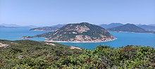
Map including the Po Toi Group (AMS, 1954)
Tin Hau Temple at Tai Wan (大灣) Bay, Po Toi
The southwest-facing slope of Beaufort Island (Lo Chau)
View of Stanley Peninsula in the southeast of Hong Kong Island. On the left, Beaufort Island and Po Toi Island (behind Beaufort), are visible.

Po Toi Islands include:

  • Lo Chau Pak Pai (螺洲白排)
  • Beaufort Island (螺洲)
  • Mat Chau (墨洲), an islet off Po Toi island
  • Mat Chau Pai (墨洲排), an islet off Mat Chau
  • Po Toi (蒲台), 3.69 km2
  • Sai Pai (細排)
  • San Pai (散排)
  • Sung Kong (宋崗)
  • Tai Pai (大排)
  • Beaufort Island & Lo Chau Mun (Deepest part of Hong Kong)
    Waglan Island (橫瀾島)

Name

For the origin of the name, see Po Toi.

Transport

The islands are accessible by private ferry (kai-to) or water taxi. Scheduled ferries connect Po Toi island with Aberdeen and Stanley.[3]

See also

References


No tags for this post.