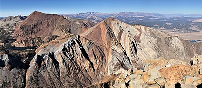
Laurel Mountain is a peak in Mono County, California. It lies in the Sherwin Range of the Sierra Nevada and is in the Inyo National Forest and the John Muir Wilderness. It reaches a height of 11,818 feet (3,602 m)[1] and is largely composed of metamorphic rock caused by contact with an intruding pluton in the late Cretaceous.[4]

References
- ^ a b c "Laurel". NGS Data Sheet. National Geodetic Survey, National Oceanic and Atmospheric Administration, United States Department of Commerce. Retrieved December 20, 2012.
- ^ "Laurel Mountain, California". Peakbagger.com. Retrieved January 17, 2014.
- ^ a b Secor, R.J. (2009). The High Sierra Peaks, Passes, and Trails (3rd ed.). Seattle: The Mountaineers. p. 367. ISBN 978-0898869712.
- ^ Lackey, JS; Valley, JW (2004). "Complex patterns of fluid flow during wollastonite formation in calcareous sandstones at Laurel Mountain, Mt. Morrison Pendant, California". GSA Bulletin. 116 (1–2): 76–93. doi:10.1130/B25239.1.


