


Wolchulsan
| Wolchulsan | |
|---|---|
 Wolchulsan mountain peak | |
| Highest point | |
| Coordinates | 34°46′04″N 126°42′16″E / 34.76778°N 126.70444°E[1] |
| Dimensions | |
| Width | 0.053 km (0.033 mi)[2] |
| Area | 42 km2 (16 mi2)[3] |
| Naming | |
| Etymology | Moon rising mountain |
| Nickname | Mount Kumgang of Honam |
| Geography | |
 | |
| Location | Yeongam and Gangjin counties |
| Country | South Korea |
| Region | Honam |
| Range coordinates | 34°46′4″N 126°42′16″E / 34.76778°N 126.70444°E |
| Biome | Warm-temperate forest and subtropical forest ecosystems |
| Climbing | |
| Normal route | Cheonhwangsa Loop |
| Access | Challenging, rock climbing |
Wolchulsan (Korean: 월출산) is a mountain located in South Jeolla Province, South Korea; and spans both Gangjin and Yeongam counties. At its peak, Cheonhwangbong, it rises to 808.7 meters, making it the highest point in Gangjin County.
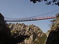
It lies in a national park of the same name. Wolchulsan National Park is the smallest national park of South Korea, with an area of 41 square kilometres (16 sq mi). A notable feature of the mountain is the "Cloud Bridge" (구름다리) a small suspension bridge that spans two peaks.
-
 Wolchulsan and its "Cloud Bridge"
 -
 Cloud Bridge
 -
 Cloud Bridge


External links
References
- ^ KTO, Korea Tourism Organization. "Wolchulsan National Park (월출산국립공원) : VISITKOREA". Wolchulsan National Park (월출산국립공원). Retrieved 2025-12-12.
- ^ "Wolchulsan Suspension Bridge (South Jeolla, 2006)". Structurae. Retrieved 2025-12-12.
- ^ "Wolchulsan National Park | Jeollanam-do, South Korea | Attractions". Lonely Planet. Retrieved 2025-12-12.