


File:Umbra level crossing near Downhill.jpg
No higher resolution available.
Umbra_level_crossing_near_Downhill.jpg (525 × 286 pixels, file size: 47 KB, MIME type: image/jpeg)
Summary
| Description |
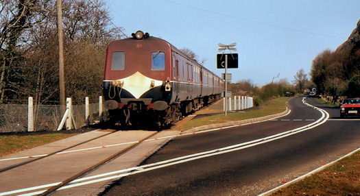
English: Umbra level crossing near Downhill The level crossing at Umbra is where the Coleraine – Downhill – Limavady road crosses the Belfast – Londonderry railway. The train is the 14.40 Londonderry – Belfast Central. At the time the crossing was an open one controlled by flashing lights. It has now reverted to automatic barriers. The rear car is no 89 – the first of the fleet of 80-class railcars to be delivered. |
| Date | |
| Source | From geograph.org.uk |
| Author | Albert Bridge |
| Permission (Reusing this file) |
Creative Commons Attribution Share-alike license 2.0 |
| Attribution (required by the license) | Albert Bridge / Umbra level crossing near Downhill / |
| Camera location | | View this and other nearby images on: OpenStreetMap |
|---|
Licensing

|
This image was taken from the Geograph project collection. See this photograph's page on the Geograph website for the photographer's contact details. The copyright on this image is owned by Albert Bridge and is licensed for reuse under the Creative Commons Attribution-ShareAlike 2.0 license.
|
This file is licensed under the Creative Commons Attribution-Share Alike 2.0 Generic license.
Attribution:
Albert Bridge
- You are free:
- to share – to copy, distribute and transmit the work
- to remix – to adapt the work
- Under the following conditions:
- attribution – You must give appropriate credit, provide a link to the license, and indicate if changes were made. You may do so in any reasonable manner, but not in any way that suggests the licensor endorses you or your use.
- share alike – If you remix, transform, or build upon the material, you must distribute your contributions under the same or compatible license as the original.
File history
Click on a date/time to view the file as it appeared at that time.
| Date/Time | Thumbnail | Dimensions | User | Comment | |
|---|---|---|---|---|---|
| current | 17:12, 12 September 2012 | | 525 × 286 (47 KB) | Karl304 | == {{int:filedesc}} == {{Information |Description={{en|1=Umbra level crossing near Downhill}} |Source=From [http://www.geograph.ie/photo/2087211 geograph.org.uk] |Date=1984-04-23 |Author=[http://www.geograph.ie/profile/5835 Albert Bridge] |Permission=C... |
File usage
The following 2 pages use this file:
Global file usage
The following other wikis use this file:
- Usage on www.wikidata.org