


Saint-Philbert-sur-Orne (French pronunciation: [sɛ̃ filbɛʁ syʁ ɔʁn] ⓘ, literally Saint-Philbert on Orne) is a commune in the Orne department in north-western France.[3]
Geography
The commune is part of the area known as Suisse Normande.[4]
The commune is made up of the following collection of villages and hamlets, La Vallée, Le Val, Le Haut Perron and Saint-Philbert-sur-Orne.[5]
The Commune with another 20 communes shares part of a 2,115 hectare, Natura 2000 conservation area, called the Vallée de l'Orne et ses affluents.[6]
The commune has 3 watercourses running through it, with 2 rivers the Orne plus one of its tributaries the Rouvre.[7][8] The other watercourse is a stream called the Val Corbel Stream.
Neighbouring communes[5] | ||||||||||||||||
|---|---|---|---|---|---|---|---|---|---|---|---|---|---|---|---|---|
| ||||||||||||||||
Places of interest
- Rock of Oëtre is one of the most prestigious lookouts in the west of France.[9]
-
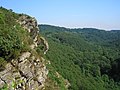 RocheD Oetre
 -
 Saint-Philbert-sur-Orne Lavoir


See also
References
- ^ "Répertoire national des élus: les maires". data.gouv.fr, Plateforme ouverte des données publiques françaises (in French). 2 December 2020.
- ^ "Populations de référence 2022" (in French). The National Institute of Statistics and Economic Studies. 19 December 2024.
- ^ "Commune de Saint-Philbert-sur-Orne (61444)". INSEE.
- ^ "Map of Suisse Normande" (PDF).
- ^ a b "Google Maps". Google Maps.
- ^ "INPN - FSD Natura 2000 - FR2500091 - Vallée de l'Orne et ses affluents - Description".
- ^ Sandre. "Fiche cours d'eau - L'Orne (I2--0200)".
- ^ Sandre. "Fiche cours d'eau - The Rouvre (I23-0400)".
- ^ "Site naturel de la Roche d'Oëtre SAINT-PHILBERT-SUR-ORNE : Normandy Tourism". Normandy Tourism, France.
| Authority control databases: National |
|---|
You must be logged in to post a comment.