


The New Guinea Portal
Introduction

New Guinea (Tok Pisin: Niugini; Hiri Motu: Niu Gini; Indonesian: Papua, fossilized Nugini, or historically Irian) is the world's second-largest island, with an area of 785,753 km2 (303,381 sq mi). Located in Melanesia in the southwestern Pacific Ocean, the island is separated from Australia by the 150-kilometre (81-nautical-mile; 93-mile) wide Torres Strait, though both landmasses lie on the same continental shelf, and were united during episodes of low sea level in the Pleistocene glaciations as the combined landmass of Sahul. Numerous smaller islands are located to the west and east. The island's name was given by Spanish explorer Yñigo Ortiz de Retez during his maritime expedition of 1545 due to the resemblance of the indigenous peoples of the island to those in the African region of Guinea. (Full article...)
Papua New Guinea, officially the Independent State of Papua New Guinea is a country in Oceania that comprises the eastern half of the island of New Guinea and offshore islands in Melanesia, a region of the southwestern Pacific Ocean north of Australia. It has a land border with Indonesia to the west and neighbours Australia to the south and the Solomon Islands to the east. Its capital, on its southern coast, is Port Moresby. The country is the world's third largest island country, with an area of 462,840 km2 (178,700 sq mi). (Full article...)
Western New Guinea, also known as Papua, Indonesian New Guinea, and Indonesian Papua, is the western half of the island of New Guinea, formerly Dutch and granted to Indonesia in 1962. Given the island is alternatively named Papua, the region is also called West Papua (Indonesian: Papua Barat). It is one of the seven geographical units of Indonesia in ISO 3166-2:ID. (Full article...)
Selected article -
-
 Sir William Jack Skate KCMG (26 September 1953 – 3 January 2006) was a prominent Papua New Guinea politician. He was the son of an Australian father and a Papua New Guinean mother. Though his career was turbulent and often marked by setbacks, he served in the highest posts in his country: prime minister of Papua New Guinea, speaker of the National Parliament, and as acting governor-general of Papua New Guinea. (Full article...)
 -

The Territory of Papua and New Guinea , officially the Administrative Union of the Territory of Papua and the Territory of New Guinea, was established by an administrative union between the Australian-administered territories of Papua and New Guinea (the latter being a United Nations trust territory administered by Australia) in 1949. In December 1971, the name of the Territory changed to "Papua New Guinea" and in 1975 it became the Independent State of Papua New Guinea. (Full article...) -
The great flying fox (Pteropus neohibernicus), also known as the greater flying fox or Bismarck flying fox, is a species of megabat in the genus Pteropus, found throughout lowland areas of New Guinea and in the Bismarck Archipelago. Conflicting evidence suggests that its closest relative is either the spectacled flying fox or, jointly, the Pelew and insular flying foxes. Two subspecies are recognized. At up to 1.6 kg (3.5 lb) in weight, it is among the heaviest bats in the world and the largest bat in Melanesia. It is a gregarious animal which roosts with hundreds or thousands of individuals. In part due to its wide variation in color, it has many taxonomic synonyms, including Pteropus degener, Pteropus papuanus, and Pteropus sepikensis. It may forage during the day or night in search of fruit, including figs or fruits from the family Sapotaceae. It is considered a least-concern species by the IUCN, though its numbers have been negatively impacted by what appeared to be a disease, as well as by hunting for bushmeat that occurs across its range. (Full article...) -

Dendrobium discolor, commonly known as antler orchid or golden orchid, is a species of epiphytic or lithophytic orchid in the family Orchidaceae, and are native to northern Australia, New Guinea, and part of Indonesia. It has cylindrical pseudobulbs, each with between ten and thirty five leathery leaves, and flowering stems with up to forty mostly brownish or greenish flowers with wavy and twisted sepals and petals. (Full article...) -

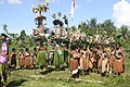
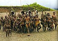
Tolai dancers
The Tolai are the indigenous people of the Gazelle Peninsula and the Duke of York Islands of East New Britain in the New Guinea Islands region of Papua New Guinea. They are ethnically close kin to the peoples of adjacent New Ireland and tribes like the Tanga people and are thought to have migrated to the Gazelle Peninsula in relatively recent times, displacing the Baining people who were driven westwards.
The majority of Tolais speak Kuanua as their first language (~100,000). Two other languages are spoken as first languages: Lungalunga and Bilur, each with approximately 2,000 speakers.
The Tolais almost universally define themselves as Christian and are predominantly Roman Catholic and United Church. Christianity was introduced to the island when Methodist ministers and teachers from Fiji arrived in the New Guinea islands region in 1875. However, in 1878 when some of the tribespeople ate four of the missionaries, the Englishman who led the missionaries, George Brown, directed and took part in a punitive expedition that resulted in a number of Tolais being killed and several villages burnt down. (Full article...) -

Milne Bay is a province of Papua New Guinea. Its capital is Alotau. The province covers 14,345 km2 of land and 252,990 km2 of sea, within the province there are more than 600 islands, about 160 of which are inhabited. The province has about 276,000 inhabitants, speaking about 48 languages, most of which belong to the Eastern Malayo-Polynesian branch of the Austronesian language family. Economically the province is dependent upon tourism, oil palm, and gold mining on Misima Island; in addition to these larger industries there are many small-scale village projects in cocoa and copra cultivation. The World War II Battle of Milne Bay took place in the province.
Culturally the Milne Bay region is sometimes referred to as the Massim, a term originating from the name of Misima Island. Massim societies are usually characterized by matrilineal descent, elaborate mortuary sequences and complex systems of ritual exchange including the Kula ring. From island group to island group and even between close lying islands, the local culture changes remarkably. What is socially acceptable on one island may not be so on another. (Full article...) -
Sir Michael Thomas Somare GCL GCMG CH CF SSI KStJ KSG PC (9 April 1936 – 25 February 2021) was a Papua New Guinean politician. Widely called the "father of the nation" (Tok Pisin: Papa blo kantri), he was the first Prime Minister after independence. At the time of his death, Somare was also the longest-serving prime minister, having been in office for 17 years over three separate terms: from 1975 to 1980; from 1982 to 1985; and from 2002 to 2011. His political career spanned from 1968 until his retirement in 2017. Besides serving as PM, he was minister of foreign affairs, leader of the opposition and governor of East Sepik Province.
He served in a variety of positions. His base was not primarily in political parties but in East Sepik Province, the area that elected him. During his political career he was a member of the House of Assembly and after independence in 1975 the National parliament for the East Sepik Provincial – later open – seat. He was the first chief minister at the end of colonial rule. Thereafter he became the first Prime Minister after independence from 1975 to 1980. He returned to the office of Prime Minister from 1982 to 1985, and his longest stint in the position was from 2002 to 2011. He also served as Cabinet Minister: he was minister of foreign affairs from 1988 to 1992; from 1999 to 2001 he was subsequently minister of foreign affairs, minister of mining and Bougainville, minister of foreign affairs and Bougainville affairs. He was leader of the opposition from 1968 to 1972, from 1980 to 1982, and thereafter in that position from 1985 to 1988, from 1992 to 1993, and finally from 2001 to 2002. When the new position of political governor as head of the provincial administration and representative MP was created in 1995, Somare took up the job. He was governor of East Sepik from 1995 until 1999. After the last election that he contended, he again became Governor of East Sepik (2012–2016). He was a founding member of the Pangu Party which led PNG into independence in 1975. He resigned from the Pangu Party and became an independent in 1988. He rejoined the Pangu Party in 1994 but was sacked as a leader in the following year. He was then asked to join and lead the National Alliance Party. In 2017 he left politics and also the National Alliance Party.
While Somare was in March 2011 hospitalised in Singapore, a majority of parliamentarians declared the post of Prime Minister vacant. Peter O'Neill was the new prime minister. This was contested. On 12 December 2011, the Supreme Court of Papua New Guinea ordered that Somare be reinstated as Prime Minister, ruling that O'Neill had not been lawfully appointed. This event triggered the 2011–12 Papua New Guinean constitutional crisis. Following a decisive victory for O'Neill in the 2012 general election, Somare expressed support for him, thereby ending the crisis and forming a coalition government. However, this truce did not last. When Somare announced his departure from politics, he made a blistering attack on O'Neill. (Full article...) -

The Territory of Papua comprised the southeastern quarter of the island of New Guinea from 1883 to 1975. In 1883, the Government of Queensland annexed this territory for the British Empire. The United Kingdom Government refused to ratify the annexation but in 1884 a protectorate was proclaimed over the territory, then called British New Guinea. There is a certain ambiguity about the exact date on which the entire territory was annexed by the British. The Papua Act 1905 recites that this happened "on or about" 4 September 1888. On 18 March 1902, the Territory was placed under the authority of the Commonwealth of Australia. Resolutions of acceptance were passed by the Commonwealth Parliament, which accepted the territory under the name of Papua.
In 1949, the Territory and the Territory of New Guinea were established in an administrative union by the name of the Territory of Papua and New Guinea. That administrative union was renamed as Papua New Guinea in 1971. Notwithstanding that it was part of an administrative union, the Territory of Papua at all times retained a distinct legal status and identity; it was a Possession of the Crown whereas the Territory of New Guinea was initially a League of Nations mandate territory and subsequently a United Nations trust territory. This legal and political distinction remained until the advent of the Independent State of Papua New Guinea in 1975.
Papua made up the southern half of what is today Papua New Guinea and contained the territory's capital, Port Moresby, which then became the capital of the independent country. (Full article...) -
The Landing at Nadzab was an airborne landing on 5 September 1943 during the New Guinea campaign of World War II in conjunction with the landing at Lae. The Nadzab action began with a parachute drop at Lae Nadzab Airport, combined with an overland force.
The parachute drop was carried out by the US Army's 503rd Parachute Infantry Regiment and elements of the Australian Army's 2/4th Field Regiment into Nadzab, New Guinea in the Markham Valley, observed by General Douglas MacArthur, circling overhead in a B-17. The Australian 2/2nd Pioneer Battalion, 2/6th Field Company, and B Company, Papuan Infantry Battalion reached Nadzab after an overland and river trek that same day and began preparing the airfield. The first transport aircraft landed the next morning, but bad weather delayed the Allied build up. Over the next days, the 25th Infantry Brigade of the Australian 7th Division gradually arrived. An air crash at Jackson's Field ultimately caused half the Allied casualties of the battle.
Once assembled at Nadzab, the 25th Infantry Brigade commenced its advance on Lae. On 11 September, it engaged the Japanese soldiers at Jensen's Plantation. After defeating them, it engaged and defeated a larger Japanese force at Heath's Plantation. During this skirmish, Private Richard Kelliher won the Victoria Cross, Australia's highest award for gallantry. Instead of fighting for Lae, the Japanese Army withdrew over the Saruwaged Range. This proved to be a gruelling test of endurance for the Japanese soldiers who had to struggle over the rugged mountains; in the end, the Japanese Army managed to withdraw its forces from Salamaua and Lae, though with extensive losses from exposure and starvation during the retreat. Troops of the 25th Infantry Brigade reached Lae shortly before those of the 9th Division that had been advancing on Lae from the opposite direction. (Full article...) -
Agriculture in Papua New Guinea has more than a 7,000 years old history, and developed out of pre-agricultural plant/food collecting and cultivation traditions of local hunter-gatherers. Currently around 85% of Papua New Guinea's population lives from semi-subsistence agriculture. 86% of all food energy consumed in Papua New Guinea is locally sourced.
Papua New Guinea produces and exports agricultural, timber, and fish products. Agriculture in 2017 accounted for 22.1% of the GDP and supported more than 80% of the population. Cash crops ranked by value are coffee, oil, cocoa, copra, tea, rubber, and sugar. The timber industry was not active in 1998, due to low world prices, but rebounded in 1999. About 40% of the country is covered with timber rich trees, and a domestic woodworking industry has been slow to develop. 99% of fishing exports are either tuna or tuna byproduct. Papua New Guinea has the largest yam market in Asia. (Full article...) -
The Trans-Papua Highway (Indonesian: Jalan Raya Trans-Papua) refers to 12 road segments, some under construction, across Western New Guinea in Indonesia, located in the island of New Guinea. The roads stretch from Sorong to Merauke with a total length of 4,325 km (2,687 mi). As of March 2017, 3,850 km (2,390 mi) of roads had been completed and construction on all the roads was predicted to finish in 2018, but construction was delayed in late 2018 due to armed conflict.
The completed road segments include 884 out of Indonesia's 1,068 km border road with Papua New Guinea. As of May 2017, the remaining parts of the road, including 7,000 meters of bridges, were planned to be completed in 2017 and 2018, although not all of the road has been layered by asphalt. As of October 2020, the road was only 200–300 km from completion. (Full article...) -

The Papuan Peninsula, also known as the Bird's Tail Peninsula, is a large peninsula in Papua New Guinea, southeast of the city of Lae, that makes up the southeastern portion of the island of New Guinea. The peninsula is the easternmost extent of the New Guinea Highlands and consists largely of the Owen Stanley Range, with peaks such as Mount Victoria (4,038 m) and Mount Suckling (3,676 m). On the south coast is Port Moresby, the capital and largest city of Papua New Guinea.
The island of New Guinea is often visualized as being in the shape of a bird, with the Bird's Head Peninsula being at the northwest end of the island, and the Bird's Tail Peninsula at the southeast end. For example, American soldiers in WWII visualized it specifically as a turkey, and referenced the anatomy of the bird as a shorthand for explaining where various actions and deployments occurred on the island. (Full article...) -
Kokoda is a station town in the Oro Province of Papua New Guinea. It is famous as the northern end of the Kokoda Track, site of the eponymous Kokoda Track campaign of World War II. In that campaign, it had strategic significance because it had the only airfield along the Track. In the decades preceding, it had been a foothills settlement near the gold fields.
Kokoda is located within the administrative divisions of Kokoda Rural LLG. (Full article...) -
Bougainville, an autonomous region of Papua New Guinea (PNG), has been inhabited by humans for at least 29,000 years, according to artefacts found in Kilu Cave on Buka Island. The region is named after Bougainville Island, the largest island of the Solomon Islands archipelago, but also contains a number of smaller islands.
The first arrivals in Bougainville were ethnically Australo-Melanesian, related to Papuans and Aboriginal Australians. Around 3,000 years ago, Austronesians associated with the Lapita culture also settled on the islands, bringing agriculture and pottery. Present-day Bougainvilleans are descended from a mixture of the two populations, and both Austronesian and non-Austronesian languages are spoken to this day.
In 1616, Dutch explorers Willem Schouten and Jacob Le Maire became the first Europeans to sight the islands. The main island was named after French admiral Louis Antoine de Bougainville, who reached it in 1768. The German Empire placed Bougainville under a protectorate in 1886, while the remainder of the Solomon Islands became part of the British Empire in 1893. The present-day boundaries between Papua New Guinea and Solomon Islands were established by the Tripartite Convention of 1899. The incorporation of Bougainville into German New Guinea initially had little economic impact, although the associated Catholic missions succeeded in converting a majority of the islanders to Christianity. (Full article...) -
East New Britain is a province of Papua New Guinea, consisting of the north-eastern part of the island of New Britain and the Duke of York Islands. The capital of the province is Kokopo, not far from the old capital of Rabaul, which was largely destroyed in a volcanic eruption in 1994. East New Britain covers a total land area of 15,816 square kilometres (6,107 sq mi), and the province's population was reported as 220,133 in the 2000 census, rising to 328,369 in the 2011 count. Provincial coastal waters extend over an area of 104,000 square metres (26 acres). The province's only land border is with West New Britain Province to the west, and it also shares a maritime border with New Ireland Province to the east.
East New Britain has a dual economy: a cash economy operates side by side with the subsistence-farming sector. The main crops produced for export are cocoa and copra. Tourism continues to be an increasingly important sector of the provincial economy. (Full article...)


Did you know (auto-generated)

- ... that Australian official Jack Emanuel was awarded the George Cross in 1971 after being stabbed to death whilst trying to resolve a land dispute with the Tolai people of New Guinea?
- ... that David Dexter, who wrote the New Guinea volume in the series Australia in the War of 1939–1945, was a commando who served in East Timor and New Guinea?
- ... that until Rufina Peter and Kessy Sawang's election in August 2022, Papua New Guinea was one of only three countries without a woman in parliament?
- ... that Australiformis semoni is a parasite that infests marsupials in Australia and New Guinea and whose infestation could cause debilitating ulcerative granulomatous gastritis?
- ... that Dorkas Tokoro-Hanasbey, the only female member of the New Guinea Council, arrived thirty minutes late to her inauguration ceremony?
- ... that artifacts of Papua New Guinean art were called "living spirits with fixed abodes"?
General images -
-
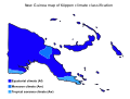 Papua New Guinea map of Köppen climate classification (from New Guinea)
 -
 A Japanese military map of New Guinea from 1943 (from New Guinea)
 -
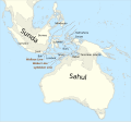 Map showing the combined landmass of Sahul formed during Pleistocene glacations (from New Guinea)
 -
 Mount Bosavi (from New Guinea)
 -
 Dutch colonial civil servant in the Baliem Valley, 1958 (from Western New Guinea)
 -
 Tifa, a Papuan musical instrument (from Western New Guinea)
 -
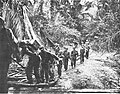
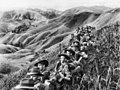 Australian soldiers resting in the Finisterre Ranges of New Guinea while en route to the front line (from New Guinea)
 -
 Fort Du Bus in 1828 (from Western New Guinea)
 -
 The Sukarno-era West Irian Liberation Monument in Lapangan Banteng, Jakarta. (from Western New Guinea)
 -
 New Guinea crocodile (from New Guinea)
 -
 The rugged and mountainous topography of Western New Guinea. (from Western New Guinea)
 -
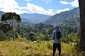 Highlands of Papua New Guinea (from New Guinea)
 -
 Skouw border checkpoint, on the Indonesia-Papua New Guinea border (from Western New Guinea)
 -
 Free West Papua protest in Melbourne, Australia, August 2012. (from Western New Guinea)
 -
 Regions of Oceania: Australasia, Polynesia, Micronesia, and Melanesia. Physiographically, Australasia includes the Australian landmass (including Tasmania), New Zealand, and New Guinea (from New Guinea)
 -
 Sentani International Airport in Jayapura is the principal point of entry to Papua (from Western New Guinea)
 -
 Dutch expeditions in Netherlands New Guinea 1907–1915. (from Western New Guinea)
 -
 Yali Mabel, Kurulu Village War Chief at Baliem Valley (from New Guinea)
 -
 A section of Trans-Papua Highway connecting Deiyai and Mimika in Central Papua (from Western New Guinea)
 -
 Australian troops at Milne Bay, Papua.The Australian garrison was the first to inflict defeat on the Imperial Japanese Army during World War II at the Battle of Milne Bay of Aug–Sep 1942. (from History of Papua New Guinea)
 -
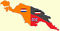 New Guinea from 1884 to 1919. The Netherlands controlled the western half of New Guinea, Germany the north-eastern part, and Britain the south-eastern part. (from New Guinea)
 -
 Kepala Panjang dance, a sacred healing ritual to absorb negative energy of the Draa people from Yaffi District in Keerom. (from Western New Guinea)
 -
 Map of New Guinea, with place names as used in English in the 1940s (from New Guinea)
 -
 Papeda, a notable dish originating from Eastern Indonesia (from Western New Guinea)
 -
The continent of Sahul before the rising ocean sundered Australia and New Guinea after the last ice age (from New Guinea)
-
 Handover ceremony of West Irian Governorship from Jan Bonay to Frans Kaisiepo, 1965 (from Western New Guinea)
 -
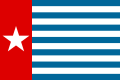
 West Papuan separatists raising the Morning-Star flag in the jungles of Papua, 1971 (from Western New Guinea)
 -
 Paradisaea apoda, native to Papua, displaying its feathers (from Western New Guinea)
 -
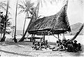
 Sago is a typical Papuan food, which is usually made into papeda. (from Western New Guinea)
 -
 Hoisting the German flag at Mioko in 1884 (from History of Papua New Guinea)
 -
 Since 2002, display of the flag of West Papua is allowed in West Papua only if accompanied by, and not raised higher than, the flag of Indonesia. (from Western New Guinea)
 -
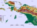
 Topographical map of New Guinea (from New Guinea)
 -
 Trans-New Guinea languages (multi-coloured), Austronesian languages (gold), and other languages (grey) (from Western New Guinea)
 -
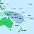 New Guinea located in relation to Melanesia (from New Guinea)
 -
 The king bird-of-paradise is one of over 300 bird species on the peninsula. (from Western New Guinea)
 -
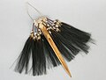 Traditional Papuan dagger (from Western New Guinea)
 -
 Grasberg Mine in Mimika Regency. Mining is the most important sector in the province (from Western New Guinea)
 -
![Image 38M.S. Rumagesan, Silas Papare, N.L.Suwages, Soegoro Atmoprasodjo [id], and A.H. Nasution in Putra-putra Irian Barat ('Sons of Irian Barat') Conference in Cibogo Bogor, 14–15 April 1961 (from Western New Guinea)](https://upload.wikimedia.org/wikipedia/commons/thumb/7/74/MS_Rumagesan%2C_Silas_Papare%2C_NL_Suwages%2C_Sugoro%2C_dan_AH_Nasution_berbincang-bincang%2C_Konferensi_Cibogo.jpg/120px-MS_Rumagesan%2C_Silas_Papare%2C_NL_Suwages%2C_Sugoro%2C_dan_AH_Nasution_berbincang-bincang%2C_Konferensi_Cibogo.jpg) M.S. Rumagesan, Silas Papare, N.L.Suwages, Soegoro Atmoprasodjo, and A.H. Nasution in Putra-putra Irian Barat ('Sons of Irian Barat') Conference in Cibogo Bogor, 14–15 April 1961 (from Western New Guinea)
M.S. Rumagesan, Silas Papare, N.L.Suwages, Soegoro Atmoprasodjo, and A.H. Nasution in Putra-putra Irian Barat ('Sons of Irian Barat') Conference in Cibogo Bogor, 14–15 April 1961 (from Western New Guinea) -

-
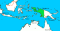
 Political divisions of New Guinea (2006) (from New Guinea)
 -
 Western New Guinea was formally annexed by Indonesia in 1969. (from New Guinea)
 -
 Jayapura, the most populus and largest cities on the island of New Guinea (Papua) (from New Guinea)
 -
 Yali in the Yahukimo Regency (from Western New Guinea)
 -
-
 Traditional Papuan war dance from the Yapen Islands (from Western New Guinea)
 -
 New Guinea Volunteer Rifles with captured Japanese flag, 1942 (from History of Papua New Guinea)
 -
 An Australian soldier, Private George "Dick" Whittington, is aided by Papuan orderly Raphael Oimbari, near Buna on 25 December 1942. (from History of Papua New Guinea)
 -
-
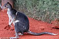 Dorcopsis hageni, native to northern region of New Guinea. (from Western New Guinea)
 -
 Culture parade in Biak (from Western New Guinea)
 -
 The raggiana bird-of-paradise is native to New Guinea. (from New Guinea)
 -
 Koiari village near Bootless Inlet, British New Guinea (from History of Papua New Guinea)
 -
 The Nagarakertagama mentioned a region in the east called Wanin, present-day Onin Peninsula in the Fakfak Regency, West Papua (from Western New Guinea)
 -
-
Dutch expeditions in Netherlands New Guinea 1907–1915. (from Western New Guinea)
-
 The floristic region of Malesia (from New Guinea)
 -

-
 Rp 0.12 Indonesian stamp of 1963. (from Western New Guinea)
 -

-
 Group of natives at Mairy Pass. Mainland of British New Guinea in 1885. (from New Guinea)
 -
 Flag under German control of New Guinea. (from History of Papua New Guinea)
 -
 A typical map from the Golden Age of Netherlandish cartography. Australasia during the Golden Age of Dutch exploration and discovery (ca. 1590s–1720s): including Nova Guinea (New Guinea), Nova Hollandia (mainland Australia), Van Diemen's Land (Tasmania), and Nova Zeelandia (New Zealand). (from History of Papua New Guinea)
 -
 Papuans on the Lorentz River, photographed during the third South New Guinea expedition in 1912–13 (from New Guinea)
 -
 The lowland rainforest of the Western New Guinea (from Western New Guinea)
 -

-
Regions of Oceania: Australasia, Polynesia, Micronesia, and Melanesia. Australasia include the Australian landmass (including Tasmania), New Zealand, and New Guinea. (from History of Papua New Guinea)
-
 Dutch and Papuan officials during the opening of the Central Hospital in Hollandia, 1959 (from Western New Guinea)
 -
 Coral reefs in Papua New Guinea (from New Guinea)
 -
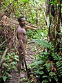
Korowai tribesman (from New Guinea)
-
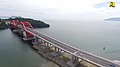 Youtefa Bridge, currently the longest bridge in Papua (from Western New Guinea)
 -
 Local people from Biak during a ceremony (from Western New Guinea)
 -
A 1644 map of New Guinea and the surrounding area (from New Guinea)
-
 British flag raised in Queensland 1883 (from History of Papua New Guinea)
 -
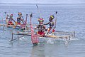
 Fishing boats in Biak (from Western New Guinea)


![Image 38M.S. Rumagesan, Silas Papare, N.L.Suwages, Soegoro Atmoprasodjo [id], and A.H. Nasution in Putra-putra Irian Barat ('Sons of Irian Barat') Conference in Cibogo Bogor, 14–15 April 1961 (from Western New Guinea)](https://kihulane.eu/encyclopedia/dmitri-medvedjev?rdp_we_resource=https%3A%2F%2Fen.wikipedia.org%2Fwiki%2FFile%3AMS_Rumagesan%2C_Silas_Papare%2C_NL_Suwages%2C_Sugoro%2C_dan_AH_Nasution_berbincang-bincang%2C_Konferensi_Cibogo.jpg)


Related portals
WikiProjects
General topics
Categories

Associated Wikimedia
The following Wikimedia Foundation sister projects provide more on this subject:
-
 Commons
Free media repository -
 Wikibooks
Free textbooks and manuals -
 Wikidata
Free knowledge base -
 Wikinews
Free-content news -
 Wikiquote
Collection of quotations -
 Wikisource
Free-content library -
 Wikiversity
Free learning tools -
 Wiktionary
Dictionary and thesaurus
External media

More portals


You must be logged in to post a comment.