


Size of this preview: 800 × 524 pixels. Other resolutions: 320 × 210 pixels | 640 × 420 pixels | 958 × 628 pixels.
Original file (958 × 628 pixels, file size: 23 KB, MIME type: image/png)
Summary
| Description |
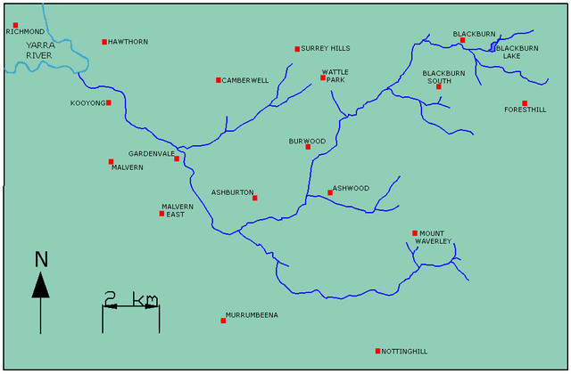
English: Map of Gardiners Creek, Melbourne.
The map contains a minor suburb name error, Gardenvale (a bayside suburb) should be Gardiner |
| Date | 4 September 2006 (original upload date) |
| Source | Transferred from en.wikipedia to Commons. |
| Author | Lentisco at English Wikipedia |
Licensing
| This work has been released into the public domain by its author, Lentisco at English Wikipedia. This applies worldwide. In some countries this may not be legally possible; if so: Lentisco grants anyone the right to use this work for any purpose, without any conditions, unless such conditions are required by law. |
Original upload log
The original description page was here. All following user names refer to en.wikipedia.
- 2006-09-04 02:47 Lentisco 958×628× (23351 bytes) Map of Gardiners Creek, Melbourne.
File history
Click on a date/time to view the file as it appeared at that time.
| Date/Time | Thumbnail | Dimensions | User | Comment | |
|---|---|---|---|---|---|
| current | 13:49, 24 February 2011 | | 958 × 628 (23 KB) | MartinHansV | {{Information |Description={{en|Map of Gardiners Creek, Melbourne. The map contains a minor suburb name error, Gardenvale (a bayside suburb) should be Gardiner}} |Source=Transferred from [http://en.wikipedia.org en.wikipedia] |Date={{Date|2006|09|04}} (o |
File usage
The following page uses this file:
Global file usage
The following other wikis use this file:
- Usage on de.wikipedia.org
You must be logged in to post a comment.