


Size of this preview: 800 × 543 pixels. Other resolutions: 320 × 217 pixels | 640 × 434 pixels | 1,024 × 695 pixels | 1,498 × 1,016 pixels.
Original file (1,498 × 1,016 pixels, file size: 1.56 MB, MIME type: image/jpeg)
|
This is an image of a place or building that is listed on the National Register of Historic Places in the United States of America. Its reference number is 82002182. |
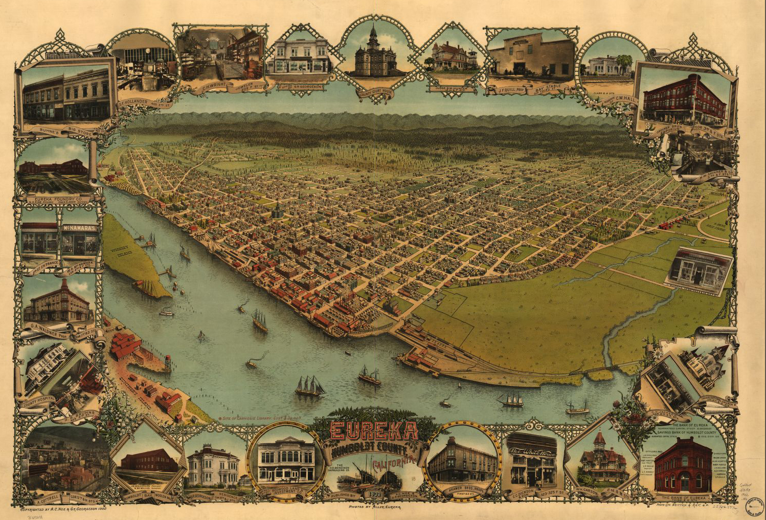
| Description | A.C. Noe's map of Eureka, California in 1902. Also called the Eureka Bird's Eye View Perspective. Map 65 X 96 cm. | ||
| Date | |||
| Source |
|
||
| Author | A.C. Noe | ||
| Permission (Reusing this file) |
|

| Object location | | View this and other nearby images on: OpenStreetMap |
|---|
The numbers on the map start at top left corner and go clockwise around.
The Caption on the Map reads:
- 1. Buhne's Big Store, 422 1st St.
- 2. S.F. Hollander, 405 2nd St.
- 3. C.H. Wright, Jeweler, 209 F St.
- 4. Office of Dr. G.R. Georgeson.
- 5. County Court House.
- 6. Judge G.W. Hunter, 12th & F Sts.
- 7. Bay Stable, J.F. Quill, Prop. 317 Third St.
- 8. Residence of C.W. Hall, Clark & A Sts.
- 9. Crocker Bros Emporium, Cor 3rd & F Sts.
- 10. R.W. Skinner & Co., 3rd and F Sts.
- 11. Warren, Armstrong & Co., 213 F St.
- 12. Jackson's Shirt Factory, C.V. Jackson Cor. 2nd & E Sts.
- 13. Congregational Church, Cor 8th & G Sts.
- 14. The Bank of Eureka, Third & E Sts.
- 15. Wm. Carson 2nd & M Sts.
- 16. The White House, C.C. Dickson & Son, 323-325 F St.
- 17. Kramer Bros., Props. First & E Sts.
- 18. The H.D. Bendixen Shipbuilding Co.
- 19. Redwood Land & Investment Co., 527-531 3rd St.
- 20. G.R. Georgeson Residence, Cor. 6th & J Sts.
- 21. Humboldt Bay Woolen Mills, J.W. Henderson, President. N.M. McMillan, Secretary.
- 22. A. Cottrell, Cor. 5th & H Sts.
- 23. H.R. Bruhns, 426 2nd St.
- 24. County Hospital.
- 25. G.A. Waldner, Prop. Cor. 1st & D Sts.
- 26. 2nd St Entrance, W.A. McNamara, Cor. 2nd & F Sts.
- 27. Eureka Foundry Co., N.H. Pine, President. Chas. H. Elsner, Secretary.
File history
Click on a date/time to view the file as it appeared at that time.
| Date/Time | Thumbnail | Dimensions | User | Comment | |
|---|---|---|---|---|---|
| current | 18:29, 31 December 2013 | | 1,498 × 1,016 (1.56 MB) | Ellin Beltz | This version is from the Library of Congress. I cropped the edges, and digitally manipulated the image to lose the center white line and the edge lines. I will update description and source after upload. |
| 21:27, 30 November 2010 |  | 1,024 × 705 (684 KB) | Flickr upload bot | Uploaded from http://flickr.com/photo/28496558@N02/2671437399 using Flickr upload bot |
File usage
The following 4 pages use this file:
Global file usage
The following other wikis use this file:
- Usage on el.wikipedia.org
- Usage on hy.wikipedia.org
- Usage on nl.wikipedia.org
- Usage on ru.wikipedia.org
You must be logged in to post a comment.