


Selle eelvaate suurus: 800 × 397 pikslit. Teised eraldusvõimed: 320 × 159 pikslit | 640 × 317 pikslit | 1307 × 648 pikslit.
Algfail (1307 × 648 pikslit, faili suurus: 101 KB, MIME tüüp: image/gif)
Lühikirjeldus

|
Vektorkujutis (SVG) sellest pildist on saadaval. Kui SVG-pilt paremat kvaliteeti võimaldab, tuleks seda rasterkujutise asemel kasutada.
File:European Middle Neolithic.gif → File:European-middle-neolithic-en.svg
|
 |
.
| Kirjeldus |
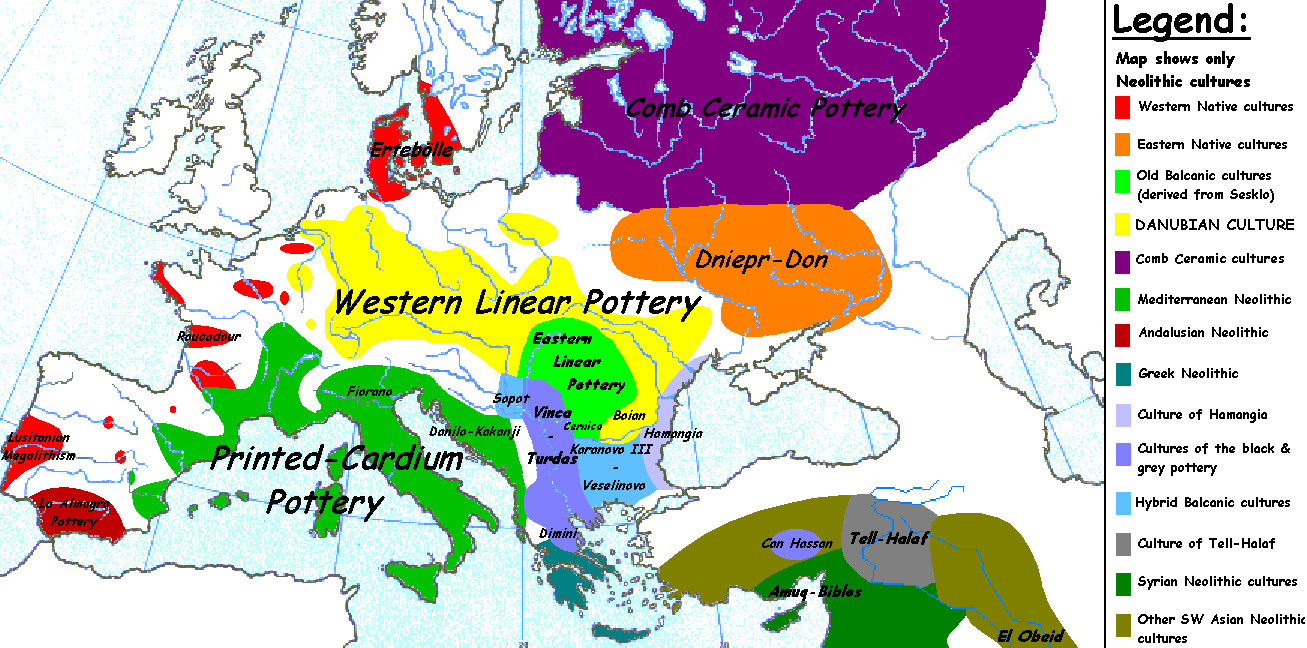
English: Map of the second half European Middle Neolithic at the apogee of Danubian and Mediterranean expansion. (The modification of the original map - Combed pottery, earlier notated as Pitted Ware, see history without respecting the color code of the legend is something that I am not fully satisfied with). |
| Kuupäev | 5. aprill 2005 (algne üleslaadimiskuupäev) |
| Allikas | Projektist en.wikipedia Commonsisse teisaldatud. |
| Autor | Later versions were uploaded by Clarifer at en.wikipedia. |
| Teised versioonid |
|


_en.png)
.png)
.jpg)
Litsents
| Autor Sugaar inglise Vikipeediast on andnud selle teose avalikku omandisse. See kehtib üleilmselt. Kui see pole mõnes riigis õiguslikult võimalik: Sugaar annab kõigile õiguse seda teost kasutada ükskõik mille jaoks, ilma ühegi tingimuseta, kui seadus neid just ei sea. |
Esialgne üleslaadimislogi
Esialgne kirjelduslehekülg oli siin. Kõik järgmised kasutajanimed viitavad projektile en.wikipedia.
- 2005-08-28 13:11 Clarifer 1320×663×8 (106148 bytes) Added the approximate area of the Comb Ceramic culture. Source: National Board of Antiquities, Finland. www.nba.fi
- 2005-04-05 20:12 Sugaar 1320×663×8 (103228 bytes) Map of the second half European Middle Neolithic at the apogee of Danubian and Mediterranean expansion (c. 4500-4000 BCE). Made by [[Sugaar]]. Free use authorized by the author.
Faili ajalugu
Klõpsa kuupäeva ja kellaaega, et näha sel ajahetkel kasutusel olnud failiversiooni.
| Kuupäev/kellaaeg | Pisipilt | Mõõtmed | Kasutaja | Kommentaar | |
|---|---|---|---|---|---|
| viimane | 18. aprill 2014, kell 08:43 | | 1307 × 648 (101 KB) | Spiridon Ion Cepleanu | Neolithic shorelines and banks, little details |
| 22. märts 2010, kell 02:39 |  | 1307 × 648 (101 KB) | Ras67 | cropped | |
| 14. veebruar 2007, kell 02:50 |  | 1320 × 663 (104 KB) | 32X | Auf eine alte Version zurückgesetzt | |
| 14. veebruar 2007, kell 02:49 |  | 1320 × 663 (101 KB) | 32X | Original version by Sugaar. | |
| 31. detsember 2005, kell 13:14 |  | 1320 × 663 (104 KB) | Glenn | Originally uploaded to en-wiki: Quote: "Map of the second half European Middle Neolithic at the apogee of Danubian and Mediterranean expansion (c. 4500-4000 BCE)." Upload text: "20:12, 5 April 2005 . . Sugaar . . 1320x663 (103228 bytes) (Map of the secon |
Faili kasutus
Seda faili kasutavad järgmised 2 lehekülge:
Globaalne failikasutus
Järgmised muud vikid kasutavad seda faili:
- Faili kasutus vikis az.wikipedia.org
- Faili kasutus vikis be.wikipedia.org
- Faili kasutus vikis bg.wikipedia.org
- Faili kasutus vikis bs.wikipedia.org
- Faili kasutus vikis ca.wikipedia.org
- Faili kasutus vikis cs.wikipedia.org
- Faili kasutus vikis da.wikipedia.org
- Faili kasutus vikis da.wikibooks.org
- Faili kasutus vikis de.wikipedia.org
- Faili kasutus vikis en.wikipedia.org
- Faili kasutus vikis fi.wikipedia.org
- Faili kasutus vikis fi.wikibooks.org
- Faili kasutus vikis gl.wikipedia.org
- Faili kasutus vikis he.wikipedia.org
- Faili kasutus vikis hi.wikipedia.org
- Faili kasutus vikis hr.wikipedia.org
- Faili kasutus vikis hu.wikipedia.org
- Faili kasutus vikis it.wikipedia.org
- Faili kasutus vikis ka.wikipedia.org
- Faili kasutus vikis lt.wikipedia.org
Vaata selle faili globaalset kasutust.