


Size of this PNG preview of this SVG file: 800 × 600 pixels. Other resolutions: 320 × 240 pixels | 640 × 480 pixels | 1,024 × 768 pixels | 1,280 × 960 pixels | 2,560 × 1,920 pixels.
Original file (SVG file, nominally 1,024 × 768 pixels, file size: 86 KB)
Summary
| Description |
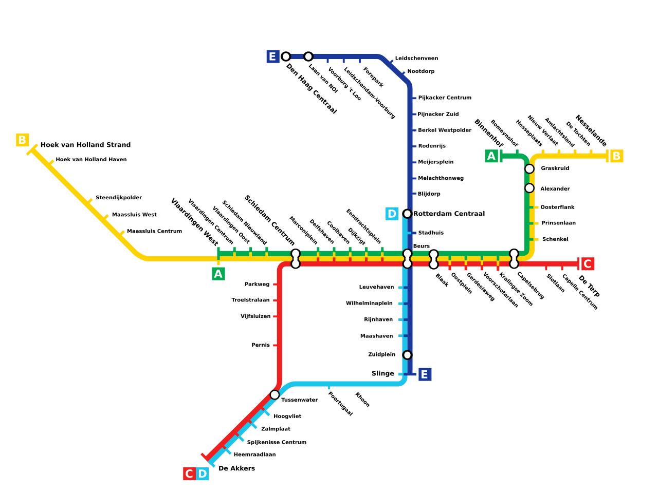
Nederlands: Kaart van de Rotterdamse metro lijnen English: Map showing planned extensions to Rotterdam Metro, scheduled to be opened between 2010 en 2012. |
| Date | |
| Source | Own work |
| Author | User:MichaBen |
Licensing
| I, the copyright holder of this work, release this work into the public domain. This applies worldwide. In some countries this may not be legally possible; if so: I grant anyone the right to use this work for any purpose, without any conditions, unless such conditions are required by law. |
File history
Click on a date/time to view the file as it appeared at that time.
| Date/Time | Thumbnail | Dimensions | User | Comment | |
|---|---|---|---|---|---|
| current | 14:44, 18 January 2010 | | 1,024 × 768 (86 KB) | MichaBen | {{Information |Description={{en|1=Map showing planned extensions to Rotterdam Metro, sheduled to be opened between 2010 en 2012.}} |Source=Own work |Author=User:MichaBen |Date=2009-11-16 |Permission= |other_versions= }} Category:Rotterdam metro |
File usage
The following 3 pages use this file:
Global file usage
The following other wikis use this file:
- Usage on be-tarask.wikipedia.org
- Usage on bg.wikipedia.org
- Usage on cs.wikipedia.org
- Usage on de.wikipedia.org
- Usage on el.wikipedia.org
- Usage on en.wikivoyage.org
- Usage on eo.wikipedia.org
- Metroo de Roterdamo
- Linio A (metroo de Roterdamo)
- Linio B (metroo de Roterdamo)
- Linio C (metroo de Roterdamo)
- Linio D (metroo de Roterdamo)
- Linio E (metroo de Roterdamo)
- Beurs (metroo de Roterdamo)
- Binnenhof (metroo de Roterdamo)
- Vlaardingen West (metroo de Roterdamo)
- Nesselande (metroo de Roterdamo)
- Hoek van Holland Haven (metroo de Roterdamo)
- De Terp (metroo de Roterdamo)
- De Akkers (metroo de Roterdamo)
- Slinge (metroo de Roterdamo)
- Rhoon (metroo de Roterdamo)
- Poortugaal (metroo de Roterdamo)
- Hoogvliet (metroo de Roterdamo)
- Tussenwater (metroo de Roterdamo)
- Zalmplaat (metroo de Roterdamo)
- Capelsebrug (metroo de Roterdamo)
- Graskruid (metroo de Roterdamo)
- Hoek van Holland Strand (metroo de Roterdamo)
- Zuidplein (metroo de Roterdamo)
- Steendijkpolder (metroo de Roterdamo)
- Stadhuis (metroo de Roterdamo)
- Leuvehaven (metroo de Roterdamo)
- Wilhelminaplein (metroo de Roterdamo)
- Rijnhaven (metroo de Roterdamo)
- Maashaven (metroo de Roterdamo)
- Spijkenisse Centrum (metroo de Roterdamo)
- Heemraadlaan (metroo de Roterdamo)
- Schenkel (metroo de Roterdamo)
- Romeynshof (metroo de Roterdamo)
- De Tochten (metroo de Roterdamo)
- Marconiplein (metroo de Roterdamo)
- Schiedam Nieuwland (metroo de Roterdamo)
- Dijkzigt (metroo de Roterdamo)
- Eendrachtsplein (metroo de Roterdamo)
- Coolhaven (metroo de Roterdamo)
- Delfshaven (metroo de Roterdamo)
- Kralingse Zoom (metroo de Roterdamo)
- Voorburg 't Loo (metroo de Roterdamo)
- Leidschendam-Voorburg (metroo de Roterdamo)
- Oosterflank (metroo de Roterdamo)
View more global usage of this file.
You must be logged in to post a comment.