


No higher resolution available.
Old_Mill,_Harnham_-_geograph.org.uk_-_1148457.jpg (640 × 427 pixels, file size: 115 KB, MIME type: image/jpeg)
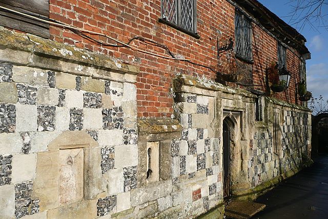
This is a photo of listed building number 1272956. |
Summary
| Description |
English: Old Mill, Harnham This restaurant is a grade 1 listed building built around 1135. Here is some of the very old stonework on the east wall above the mill race of the River Nadder, although the oldest stonework probably dates from around 1250 (just before lunch then). |
| Date | |
| Source | From geograph.org.uk |
| Author | Graham Horn |
| Attribution (required by the license) | Graham Horn / Old Mill, Harnham / |
| Camera location | | View this and other nearby images on: OpenStreetMap |
|---|
_heading:315.00&language=en)
| Object location | | View this and other nearby images on: OpenStreetMap |
|---|
_heading:315.00&language=en)
Licensing

|
This image was taken from the Geograph project collection. See this photograph's page on the Geograph website for the photographer's contact details. The copyright on this image is owned by Graham Horn and is licensed for reuse under the Creative Commons Attribution-ShareAlike 2.0 license.
|
This file is licensed under the Creative Commons Attribution-Share Alike 2.0 Generic license.
Attribution: Graham Horn
- You are free:
- to share – to copy, distribute and transmit the work
- to remix – to adapt the work
- Under the following conditions:
- attribution – You must give appropriate credit, provide a link to the license, and indicate if changes were made. You may do so in any reasonable manner, but not in any way that suggests the licensor endorses you or your use.
- share alike – If you remix, transform, or build upon the material, you must distribute your contributions under the same or compatible license as the original.
File history
Click on a date/time to view the file as it appeared at that time.
| Date/Time | Thumbnail | Dimensions | User | Comment | |
|---|---|---|---|---|---|
| current | 07:39, 25 February 2011 | | 640 × 427 (115 KB) | GeographBot | == {{int:filedesc}} == {{Information |description={{en|1=Old Mill, Harnham This restaurant is a grade 1 listed building built around 1135. Here is some of the very old stonework on the east wall above the mill race of the River Nadder, although the oldes |
File usage
The following 2 pages use this file:
Global file usage
The following other wikis use this file:
- Usage on dag.wikipedia.org
- Usage on www.wikidata.org
You must be logged in to post a comment.