


Size of this preview: 303 × 598 pixels. Other resolutions: 121 × 240 pixels | 243 × 480 pixels | 389 × 768 pixels | 518 × 1,024 pixels | 1,037 × 2,048 pixels | 4,765 × 9,412 pixels.
Original file (4,765 × 9,412 pixels, file size: 5.61 MB, MIME type: image/jpeg)
Summary
| Description |
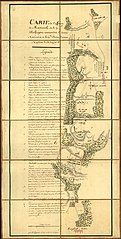
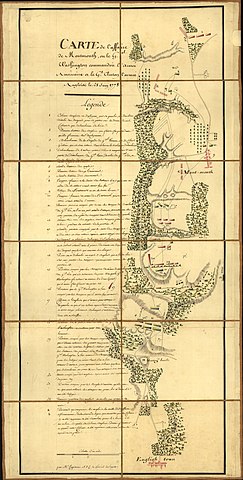
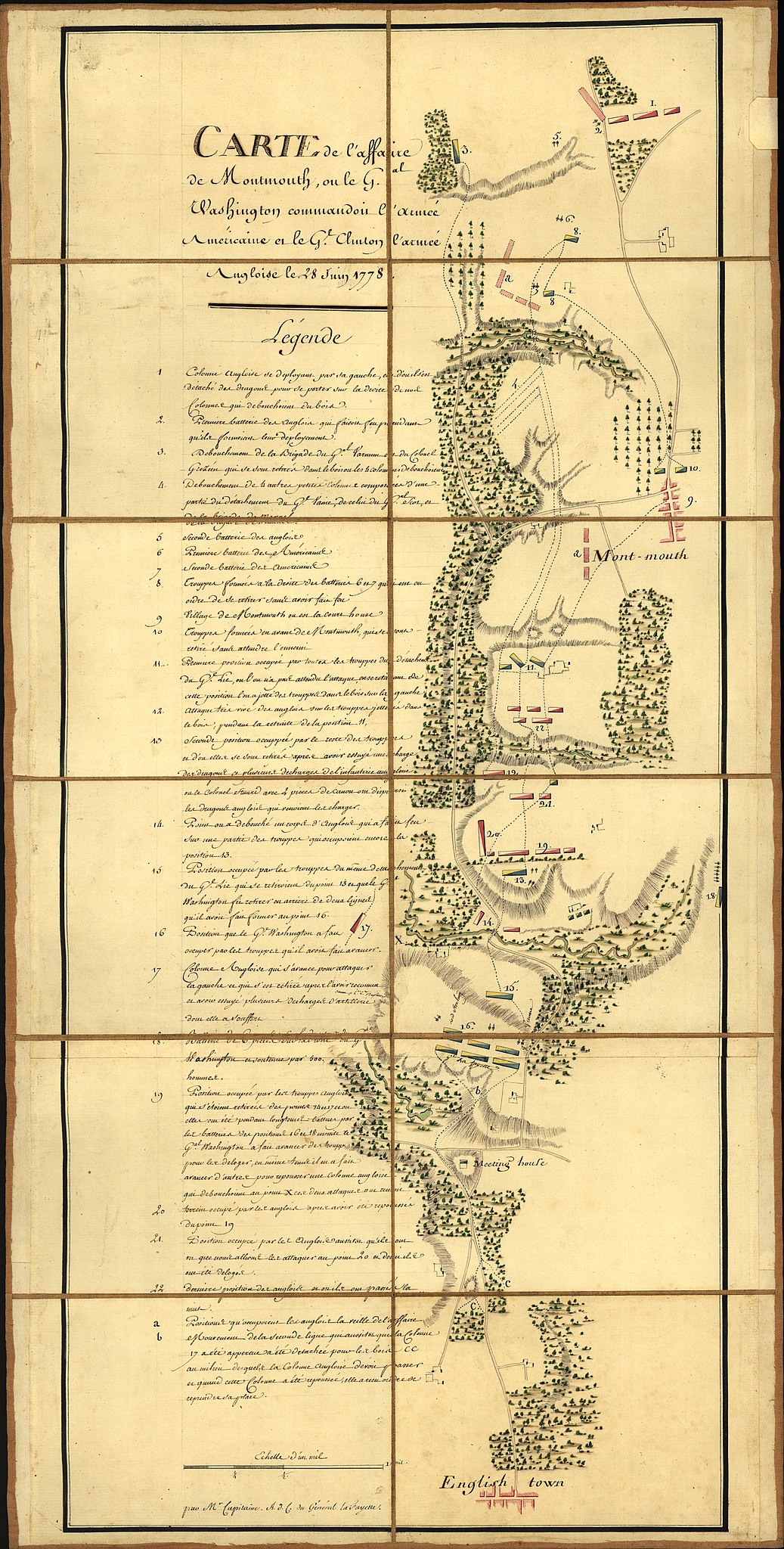
English: Map of the Battle of Monmouth Courthouse, N.J. |
||||
| Date | 1778-06-28. Publication date not given, but per the Library of Congress, "The maps in the Map Collections materials were either published prior to 1922, produced by the United States government, or both..." (Source: Library of Congress page for this item) | ||||
| Source | Library of Congress | ||||
| Author | M'r Capitaine du Chesnoy, A.d.C. du Général LaFayette. | ||||
| Permission (Reusing this file) |
|
||||

|
This map is available from the United States Library of Congress's Geography & Map Division
under the digital ID g3812m.ar300500. This tag does not indicate the copyright status of the attached work. A normal copyright tag is still required. See Commons:Licensing.
|
Licensing
|
This work is in the public domain in its country of origin and other countries and areas where the copyright term is the author's life plus 70 years or fewer. | |
| This file has been identified as being free of known restrictions under copyright law, including all related and neighboring rights. | |
This media file is in the public domain in the United States. This applies to U.S. works where the copyright has expired, often because its first publication occurred prior to January 1, 1930, and if not then due to lack of notice or renewal. See this page for further explanation.
|
 | |
 |
File history
Click on a date/time to view the file as it appeared at that time.
| Date/Time | Thumbnail | Dimensions | User | Comment | |
|---|---|---|---|---|---|
| current | 13:24, 8 October 2008 | | 4,765 × 9,412 (5.61 MB) | Pohick2 | {{Information |Description={{en|1=Map of the Battle of Monmouth Courthouse, N.J.}} |Source=Library of Congress |Author=M'r Capitaine, A.d.C. du Général LaFayette. |Date=le 28 Juin 1778 |Permission={{PD-old}} |other_versions= }} {{LOC-map|id=g3812m.ar3 |
File usage
The following 2 pages use this file:
Global file usage
The following other wikis use this file:
- Usage on fr.wikipedia.org
- Usage on it.wikipedia.org
- Usage on ja.wikipedia.org
You must be logged in to post a comment.