


File:Khmers rouges map.png

Size of this preview: 660 × 599 pixels. Other resolutions: 264 × 240 pixels | 529 × 480 pixels | 881 × 800 pixels.
Original file (881 × 800 pixels, file size: 421 KB, MIME type: image/png)
Summary
| Description |
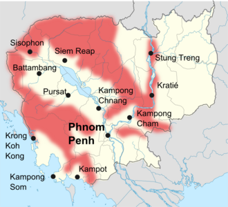
English: map of khmers rouges avtivities (1989-1990)
Français : Cartes des zones d'activités des khmers rouges en 1989-1990. from Christophe Peschoux,Les «nouveaux» khmers rouges (1979-1990), Annexe |
| Date | |
| Source | self made using File:Cambodia location map.svg by NordNordWest |
| Author | toony |
Licensing
I, the copyright holder of this work, hereby publish it under the following licenses:

|
Permission is granted to copy, distribute and/or modify this document under the terms of the GNU Free Documentation License, Version 1.2 or any later version published by the Free Software Foundation; with no Invariant Sections, no Front-Cover Texts, and no Back-Cover Texts. A copy of the license is included in the section entitled GNU Free Documentation License. |
This file is licensed under the Creative Commons Attribution-Share Alike 4.0 International, 3.0 Unported, 2.5 Generic, 2.0 Generic and 1.0 Generic license.
- You are free:
- to share – to copy, distribute and transmit the work
- to remix – to adapt the work
- Under the following conditions:
- attribution – You must give appropriate credit, provide a link to the license, and indicate if changes were made. You may do so in any reasonable manner, but not in any way that suggests the licensor endorses you or your use.
- share alike – If you remix, transform, or build upon the material, you must distribute your contributions under the same or compatible license as the original.
You may select the license of your choice.
File history
Click on a date/time to view the file as it appeared at that time.
| Date/Time | Thumbnail | Dimensions | User | Comment | |
|---|---|---|---|---|---|
| current | 21:14, 2 August 2010 | | 881 × 800 (421 KB) | Toony | {{Information |Description={{en|1=map of khmers rouges avtivities (1989-1990)}} {{fr|1=Cartes des zones d'activités des khmers rouges en 1989-1990.}} |Source=self made |Author=toony |Date=2010 |Permission= |other_versions= }} from Christophe Peschoux,''L |
File usage
The following 3 pages use this file:
Global file usage
The following other wikis use this file:
- Usage on ba.wikipedia.org
- Usage on de.wikipedia.org
- Usage on fa.wikipedia.org
- Usage on fr.wikipedia.org
- Usage on hy.wikipedia.org
- Usage on ja.wikipedia.org
- Usage on ky.wikipedia.org
- Usage on no.wikipedia.org
- Usage on pl.wikipedia.org
- Usage on pt.wikipedia.org
- Usage on ru.wikipedia.org
- Usage on vi.wikipedia.org