


Size of this preview: 367 × 599 pixels. Other resolutions: 147 × 240 pixels | 294 × 480 pixels | 655 × 1,069 pixels.
Original file (655 × 1,069 pixels, file size: 152 KB, MIME type: image/jpeg)
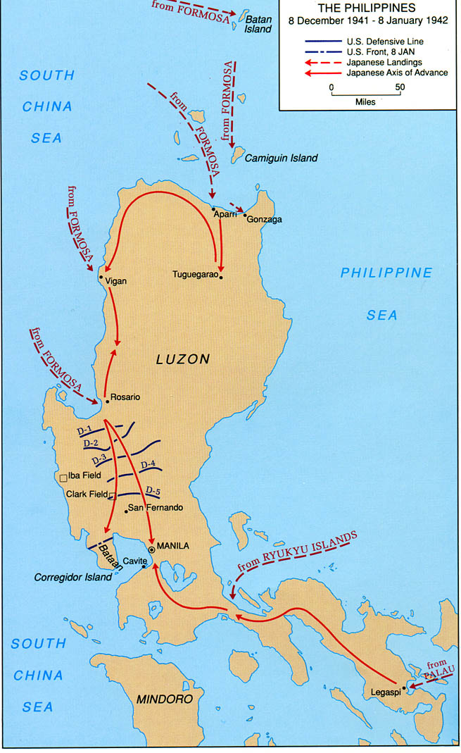
| Description | Map of Luzon, Philippines showing Japanese landings and advances from 8 December 1941 to 8 January 1942. | |||
| Source | http://www.army.mil/cmh-pg/brochures/pi/PI.htm | |||
| Author | ||||
| Permission (Reusing this file) |
|

File history
Click on a date/time to view the file as it appeared at that time.
| Date/Time | Thumbnail | Dimensions | User | Comment | |
|---|---|---|---|---|---|
| current | 20:53, 26 September 2007 | | 655 × 1,069 (152 KB) | Wwoods | {{Information |Description= Map of Luzon, Philippines showing Japanese landings and advances from 8 December 1941 to 8 January 1942. |Source= http://www.army.mil/cmh-pg/brochures/pi/PI.htm |Date= |Author= |Permission= {{PD-USGov-Military-Army-USACMH}} |ot |
File usage
The following 9 pages use this file:
- Japanese invasion of Aparri
- Japanese invasion of Batan Island
- Japanese invasion of Lamon Bay
- Japanese invasion of Legazpi
- Japanese invasion of Lingayen Gulf
- Japanese invasion of Vigan
- List of conflicts in the Philippines
- Philippines campaign (1941–1942)
- User:Falcaorib/Canada, United States and Mexico
Global file usage
The following other wikis use this file:
- Usage on azb.wikipedia.org
- Usage on bg.wikipedia.org
- Usage on de.wikipedia.org
- Usage on fi.wikipedia.org
- Usage on fr.wikipedia.org
- Usage on he.wikipedia.org
- Usage on no.wikipedia.org
- Usage on pl.wikipedia.org
- Usage on ro.wikipedia.org
- Usage on ru.wikipedia.org
- Usage on vi.wikipedia.org
- Usage on www.wikidata.org
You must be logged in to post a comment.