


Size of this PNG preview of this SVG file: 800 × 465 pixels. Other resolutions: 320 × 186 pixels | 640 × 372 pixels | 1,024 × 595 pixels | 1,280 × 744 pixels | 2,560 × 1,488 pixels | 1,020 × 593 pixels.
Original file (SVG file, nominally 1,020 × 593 pixels, file size: 69 KB)
| U.S. presidential election maps (SVG) |
| See also: National Atlas maps (png) |
|
1788-1789 · 1792 · 1796 · 1800 · 1804 · 1808 · 1812 · 1816 · 1820 · 1824 · 1828 · 1832 · 1836 · 1840 · 1844 · 1848 · 1852 · 1856 · 1860 · 1864 · 1868 · 1872 · 1876 · 1880 · 1884 · 1888 · 1892 · 1896 · 1900 · 1904 · 1908 · 1912 · 1916 · 1920 · 1924 · 1928 · 1932 · 1936 · 1940 · 1944 · 1948 · 1952 · 1956 · 1960 · 1964 · 1968 · 1972 · 1976 · 1980 · 1984 · 1988 · 1992 · 1996 · 2000 · 2004 · 2008 · 2012 · 2016 · 2020 · 2024 |
Any autoconfirmed user can overwrite this file from the same source. Please ensure that overwrites comply with the guideline.
Summary
| Description |
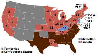
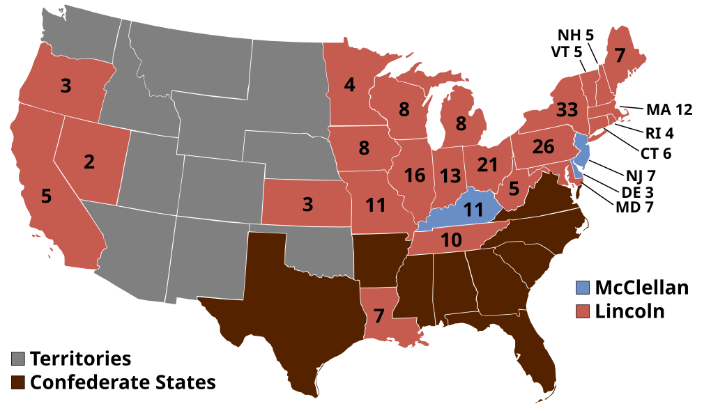
English: 1864 Electoral College |
| Source | Own work |
| Author | AndyHogan14 |
Licensing
| I, the copyright holder of this work, release this work into the public domain. This applies worldwide. In some countries this may not be legally possible; if so: I grant anyone the right to use this work for any purpose, without any conditions, unless such conditions are required by law. |
File history
Click on a date/time to view the file as it appeared at that time.
| Date/Time | Thumbnail | Dimensions | User | Comment | |
|---|---|---|---|---|---|
| current | 16:39, 20 December 2024 | | 1,020 × 593 (69 KB) | Elli | Reverted to version as of 03:18, 23 September 2024 (UTC) they did vote, even though their votes were not counted |
| 10:54, 14 November 2024 |  | 1,020 × 593 (27 KB) | Arnapha | Clearer state borders | |
| 01:04, 13 November 2024 |  | 1,020 × 593 (80 KB) | Tandreasen0421 | Reverted to version as of 23:51, 12 November 2024 (UTC). National Union Party, Tennessee and Louisiana in the Confederacy. | |
| 01:02, 13 November 2024 |  | 1,020 × 593 (72 KB) | Tandreasen0421 | Reverted to version as of 00:59, 13 November 2024 (UTC) | |
| 01:01, 13 November 2024 |  | 1,020 × 593 (101 KB) | Tandreasen0421 | Reverted to version as of 02:37, 12 November 2024 (UTC) | |
| 01:01, 13 November 2024 |  | 2,560 × 1,489 (487 KB) | Tandreasen0421 | National Union Party, Tennessee and Louisiana in the Confederacy. | |
| 00:59, 13 November 2024 |  | 1,020 × 593 (72 KB) | Tandreasen0421 | Reverted to version as of 23:11, 17 June 2021 (UTC) | |
| 23:51, 12 November 2024 |  | 1,020 × 593 (80 KB) | Tandreasen0421 | Reverted to version as of 04:25, 17 November 2016 (UTC). This version was the same as the previous. | |
| 23:49, 12 November 2024 |  | 2,560 × 1,489 (487 KB) | Tandreasen0421 | Added a new version of the map with the National Union Party and even Tennessee and Louisiana in the Confederacy. | |
| 02:37, 12 November 2024 |  | 1,020 × 593 (101 KB) | Tandreasen0421 | Reverted to version as of 02:25, 12 November 2024 (UTC) |
File usage
The following 55 pages use this file:
- 1864 United States elections
- 1864 United States presidential election
- 1864 United States presidential election in California
- 1864 United States presidential election in Connecticut
- 1864 United States presidential election in Delaware
- 1864 United States presidential election in Illinois
- 1864 United States presidential election in Indiana
- 1864 United States presidential election in Iowa
- 1864 United States presidential election in Kansas
- 1864 United States presidential election in Kentucky
- 1864 United States presidential election in Louisiana
- 1864 United States presidential election in Maine
- 1864 United States presidential election in Maryland
- 1864 United States presidential election in Massachusetts
- 1864 United States presidential election in Michigan
- 1864 United States presidential election in Minnesota
- 1864 United States presidential election in Missouri
- 1864 United States presidential election in Nevada
- 1864 United States presidential election in New Hampshire
- 1864 United States presidential election in New Jersey
- 1864 United States presidential election in New York
- 1864 United States presidential election in Ohio
- 1864 United States presidential election in Oregon
- 1864 United States presidential election in Pennsylvania
- 1864 United States presidential election in Rhode Island
- 1864 United States presidential election in Tennessee
- 1864 United States presidential election in Vermont
- 1864 United States presidential election in West Virginia
- 1864 United States presidential election in Wisconsin
- Abraham Lincoln
- Electoral vote changes between United States presidential elections
- George McClellan 1864 presidential campaign
- List of United States presidential election results by state
- Presidency of Abraham Lincoln
- United States presidential election
- User:AirForceAviator/sandbox
- User:Bigfatman8766/sandbox
- User:DukeOfDelTaco/U.S. Presidential Elections
- User:Falcaorib/United States presidential elections
- User:MBisanz/Images
- User:Max96/sandbox
- User:Orser67/Lincoln
- User:RapidsLurker15/United States presidential elections
- User:Whackyasshackysack/sandbox
- Wikipedia:Graphics Lab/Illustration workshop/Archive/Nov 2011
- Template:1864 United States presidential election imagemap
- Template:State results of the 1864 U.S. presidential election
- Draft:2036 United States presidential election
- Draft:2040 United States presidential election
- Draft:2044 United States presidential election
- Draft:2048 United States presidential election
- Draft:2052 United States presidential election
- Draft:2056 United States presidential election
- Draft:2060 United States presidential election
- Draft:2064 United States presidential election
Global file usage
The following other wikis use this file:
- Usage on ca.wikipedia.org
- Usage on ckb.wikipedia.org
- Usage on da.wikipedia.org
- Usage on de.wikipedia.org
- Usage on el.wikipedia.org
- Usage on eo.wikipedia.org
- Usage on es.wikipedia.org
- Usage on eu.wikipedia.org
- Usage on fi.wikipedia.org
- Usage on fr.wikipedia.org
- Usage on he.wikipedia.org
- Usage on it.wikipedia.org
- Usage on ja.wikipedia.org
- Usage on ka.wikipedia.org
- Usage on ko.wikipedia.org
- Usage on nl.wikipedia.org
- Usage on pl.wikipedia.org
- Usage on pt.wikipedia.org
- Usage on ru.wikipedia.org
- Usage on sr.wikipedia.org
- Usage on sv.wikipedia.org
- Usage on sw.wikipedia.org
- Usage on uk.wikipedia.org
- Usage on ur.wikipedia.org
- Usage on vi.wikipedia.org
- Usage on www.wikidata.org
- Usage on zh.wikipedia.org


You must be logged in to post a comment.