Original file (SVG file, nominally 464 × 399 pixels, file size: 61 KB)

Summary

Description
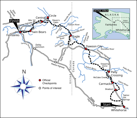
English: A map of the trail for the Yukon Quest International Sled Dog race, including checkpoints and points of interest.
Date
Source

Own work using:

  • Base map: Delorme. Alaska Atlas and Gazetteer, DeLorme Publishing. 6th edition, 2004. ISBN 0899332897
  • Base map and trail map: Hammond, DeeDee. "Yukon Quest 25th Anniversary", Fairbanks Daily News-Miner. February 6, 2008.
  • Trail map: Gilpin, Jim. "Yukon Quest Map", Yukon College. March 21, 2008. Accessed August 3, 2009.
Author JKBrooks85

Licensing

Public domain I, the copyright holder of this work, release this work into the public domain. This applies worldwide.
In some countries this may not be legally possible; if so:
I grant anyone the right to use this work for any purpose, without any conditions, unless such conditions are required by law.

Captions

Add a one-line explanation of what this file represents

Items portrayed in this file

depicts

creator

some value

Wikimedia username: JKBrooks85
author name string: JKBrooks85

copyright status

copyrighted, dedicated to the public domain by copyright holder

copyrighted

copyright license

released into the public domain by the copyright holder

inception

25 August 2009

media type

image/svg+xml

checksum

9b40823554e0b66b0d7f2eb07e73dd2c7b2ec5ef

determination method or standard: SHA-1

data size

62,281 byte

height

399 pixel

width

464 pixel

File history

Click on a date/time to view the file as it appeared at that time.

Date/TimeThumbnailDimensionsUserComment
current00:25, 26 August 2009Thumbnail for version as of 00:25, 26 August 2009464 × 399 (61 KB)JKBrooks85{{Information |Description={{en|1=A map of the route of the 2009 Yukon Quest}} |Source=Own work by uploader |Author=JKBrooks85 |Date=2009-08-25 |Permission= |other_versions= }} Category:Yukon Quest

The following page uses this file:

Global file usage

The following other wikis use this file:

No tags for this post.