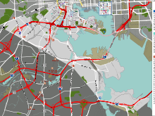
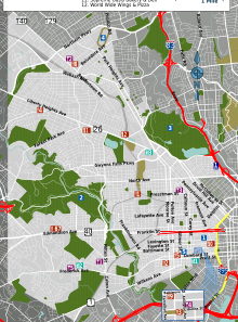
This list of Baltimore neighborhoods includes the neighborhoods of Baltimore, Maryland, divided into nine geographical regions: North, Northeast, East, Southeast, South, Southwest, West, Northwest, and Central. Each district is patrolled by a respective precinct of the Baltimore Police Department.
Charles Street down to Hanover Street and Ritchie Highway serve as the east-west dividing line and Eastern Avenue to Route 40 as the north-south dividing line. Baltimore Street is the north-south dividing line for the U.S. Postal Service.[1] It is not uncommon for locals to divide the city simply by East or West Baltimore, using Charles Street or I-83 as a dividing line.[citation needed]
The following is a list of major neighborhoods in Baltimore, organized by broad geographical location in the city:
Baltimore neighborhoods
A list of the neighborhoods of Baltimore listed by planning district:[2]
Northwest
- Arlington
- Callaway-Garrison, Baltimore
- Central Park Heights
- Cheswolde
- Coldspring
- Cross Country
- Cylburn
- Fallstaff
- Glen
- Gwynn Oak, Baltimore
- Greenspring
- Langston Hughes
- Levindale
- Lucille Park
- Mount Washington
- Park Circle
- Parklane
- Pimlico Good Neighbors
- Reisterstown Station/ Pikesville
- Seton Business Park, Baltimore
- Towanda-Grantley
- Woodmere
North
- Abell
- Barclay
- Bellona-Gittings
- Belvedere
- Better Waverly
- Blythewood
- Cameron Village
- Cedarcroft
- Charles North
- Charles Village (formerly Peabody Heights)
- Chinquapin Park, Baltimore
- Cross Keys
- Ednor Gardens-Lakeside
- Evergreen
- Evesham Park
- Glen Oaks
- Greenmount West
- Guilford
- Hampden
- Harwood
- Hoes Heights
- Homeland
- Idlewood
- Johns Hopkins Homewood
- Jones Falls Area
- Kenilworth Park
- Kernewood
- Keswick
- Lake Evesham
- Lake Walker
- Loyola/Notre Dame
- Mid-Govans
- New Northwood
- North Roland Park/Poplar Hill
- Oakenshawe
- Old Goucher
- The Orchards
- Original Northwood
- Pen Lucy
- Radnor-Winston
- Remington
- Richnor Springs
- Roland Park
- Rosebank
- Sabina-Mattfeldt
- Tuscany-Canterbury
- Villages at Homeland
- Waverly
- Wilson Park
- Winston-Govans
- Woodberry
- Woodbourne Heights
- Woodbourne-McCabe
- Wrenlane
- Wyman Park
- Wyndhurst
- York-Homeland
Northeast
- Arcadia
- Armistead Gardens
- Belair-Edison
- Belair-Parkside
- Beverly Hills
- Broening Manor
- Cedmont
- Cedonia
- Clifton Park
- Coldstream-Homestead-Montebello
- Eastwood
- Four By Four
- Frankford
- Glenham-Belhar
- Graceland Park
- Hamilton Hills
- Herring Run
- Hillen
- Holabird Industrial Park
- Lauraville
- Loch Raven
- Lower Herring Run Park
- Mayfield
- Medford
- Montebello
- Moravia-Walther
- Morgan Park
- Morgan State University
- Mt Pleasant Park
- North Harford Road
- Orangeville
- Orangeville Industrial Area
- Orchard Ridge
- Overlea
- Perring Loch
- Pulaski Industrial Area
- Ramblewood
- Rosemont East
- Saint Helena
- Stonewood-Pentwood-Winston
- Taylor Heights
- Waltherson
- Westfield
East and Downtown

- Baltimore Highlands
- Berea
- Biddle Street
- Brewers Hill
- Broadway East
- Butcher's Hill
- Canton
- Canton Industrial Area
- CARE
- Darley Park
- Downtown
- Downtown West
- Dundalk Marine Terminal
- East Baltimore Midway
- Ellwood Park/Monument
- Greenmount Cemetery
- Highlandtown
- Inner Harbor
- Johnston Square
- Madison-Eastend
- McElderry Park
- Milton-Montford
- Oliver
- Patterson Place
- South Clifton Park
- University of Maryland
Central
Southeast
South

- Barre Circle
- Brooklyn
- Carroll Park
- Carroll-Camden Industrial Area
- Cherry Hill
- Curtis Bay
- Curtis Bay Industrial Area
- Fairfield Area / (former Masonville & Wagner's Point - East Brooklyn)
- Federal Hill
- Franklin Square
- Hawkins Point / Arundel Cove
- Hollins Market
- Lakeland
- Locust Point
- Locust Point (North & South) Industrial Area
- Middle Branch / Broening / Reedbird Parks
- Mount Winans
- New Southwest/Mount Clare
- Otterbein
- Poppleton
- Port Covington
- Ridgely's Delight
- Riverside
- Saint Paul
- Sharp-Leadenhall
- South Baltimore
- Spring Garden Industrial Area
- Stadiums Area / Camden Yards sports complex
- Union Square
- Westport
Southwest
- Allendale
- Beechfield
- Boyd-Booth
- Carroll-South Hilton
- Carrollton Ridge
- Dickeyville
- Edgewood
- Edmondson Village
- Franklintown
- Gwynns Falls
- Gwynns Falls/Leakin Park
- Hunting Ridge
- Irvington
- Lower Edmondson Village
- Millhill
- Morrell Park
- Oaklee
- Penrose/Fayette Street Outreach
- Rognel Heights
- Saint Agnes
- Saint Josephs
- Shipley Hill
- Ten Hills
- Tremont
- Uplands
- Violetville
- Wakefield
- Washington Village/Pigtown
- West Hills
- Westgate
- Wilhelm Park
- Yale-Heights
West

- Ashburton
- Bolton Hill
- Bridgeview-Greenlawn
- Burleith-Leighton
- Central Forest Park
- Concerned Citizens of Forest Park
- Coppin Heights/Ash-Co-East
- Dolfield
- Dorchester
- Druid Heights
- Druid Hill Park
- East Arlington
- Easterwood
- Evergreen Lawn
- Fairmont
- Forest Park
- Forest Park Golf Course
- Franklintown Road
- Garwyn Oaks
- Grove Park
- Hanlon Longwood
- Harlem Park
- Heritage Crossing
- Howard Park
- Liberty Square
- Madison Park
- Midtown-Edmondson
- Mondawmin
- Mosher
- Mount Holly
- Northwest Community Action
- Panway/Braddish Avenue
- Parkview/Woodbrook
- Penn North
- Purnell
- Reservoir Hill
- Rosemont
- Rosemont Homeowners/Tenants
- Sandtown-Winchester
- Upton
- Walbrook
- West Arlington
- West Forest Park
- Winchester
- Windsor Hills
See also
References
- ^ Mary K. Tilghman (2008). Insiders' Guide to Baltimore. Morris Book Publishing LLC. p. 2. ISBN 978-0-7627-4553-1.
- ^ "Baltimore City Planning Districts" (PDF). City of Baltimore Department of Planning. June 20, 2016. Archived from the original (PDF) on December 29, 2016. Retrieved July 20, 2021.


You must be logged in to post a comment.