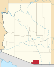
Beyerville is a census-designated place (CDP) in Santa Cruz County, Arizona, United States. The population was 177 at the 2010 census.[4]
Geography
Beyerville is located along the Santa Cruz River. Arizona State Route 82 passes through the community. Nogales lies 4 miles (6 km) to the southwest, Patagonia lies 10 miles (16 km) northeast and Sonoita lies 19 miles (31 km) northeast along route 82.[5]
According to the United States Census Bureau, the CDP has a total area of 0.35 square miles (0.9 km2), all land.[4]
Demographics
| Census | Pop. | Note | %± |
|---|---|---|---|
| 2010 | 177 | — | |
| 2020 | 72 | −59.3% | |
| U.S. Decennial Census[6] | |||
Beyerville first appeared on the 2010 U.S. Census as a census-designated place (CDP).[7] It was not a new place then, as it had had a school built in 1921.
See also
References
- ^ a b U.S. Geological Survey Geographic Names Information System: Beyerville, Arizona
- ^ "2020 U.S. Gazetteer Files". United States Census Bureau. Retrieved October 29, 2021.
- ^ "Beyerville AZ ZIP Code". zipdatamaps.com. 2023. Retrieved May 3, 2023.
- ^ a b "Geographic Identifiers: 2010 Demographic Profile Data (G001): Beyerville CDP, Arizona". U.S. Census Bureau, American Factfinder. Archived from the original on February 12, 2020. Retrieved December 4, 2012.
- ^ Arizona Atlas & Gazetteer, DeLorme, 4th ed. 2001, p. 73 ISBN 0899333257
- ^ "Census of Population and Housing". Census.gov. Retrieved June 4, 2016.
- ^ U.S. Census Bureau (October 2012). "Arizona: 2010 - Summary Population and Housing Characteristics" (PDF). U.S. Government Printing Office.


You must be logged in to post a comment.