


Avelanges (French pronunciation: [avlɑ̃ʒ]) is a commune in the Côte-d'Or department in the Bourgogne-Franche-Comté region of eastern France.
Geography
Avelanges is located some 45 km north of Dijon and 35 km east by south-east of Aignay-le-Duc. Access to the commune is by the D120 road which branches from the D112 south of Avot in the north and passes through the commune and village before continuing south-west to Marey-sur-Tille. The commune has extensive forests mixed with smaller areas of farmland.[3]
Neighbouring communes and villages
Places adjacent to Avelanges | |
|---|---|
Toponymy
The name was Arclenglis or Avelengiis in 1028, Avallangiae in 1244, and Avelanges in 1793.
Administration

List of Successive Mayors[4]
| From | To | Name |
|---|---|---|
| 2001 | 2020 | Jean Michel Moyemont |
| 2020 | 2026 | Sylvain Rebérol |
Demography

The inhabitants of the commune are known as Avelangeais or Avelangeaises in French.[5]
|
| ||||||||||||||||||||||||||||||||||||||||||||||||||||||||||||||||||||||||||||||||||||||||||||||||||||||||||||||||||
| Source: EHESS[6] and INSEE[7] | |||||||||||||||||||||||||||||||||||||||||||||||||||||||||||||||||||||||||||||||||||||||||||||||||||||||||||||||||||
Avelanges Picture Gallery
-
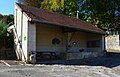
 Avelanges School
 -
 Avelanges Lavoir (Public Laundry)
 -
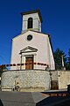 Avelanges Church
 -
 A Water Trough in Avalanges


See also
References
- ^ "Répertoire national des élus: les maires". data.gouv.fr, Plateforme ouverte des données publiques françaises (in French). 2 December 2020.
- ^ "Populations de référence 2022" (in French). The National Institute of Statistics and Economic Studies. 19 December 2024.
- ^ a b Google Maps
- ^ List of Mayors of France (in French)
- ^ Le nom des habitants du 21 - Côte-d'Or, habitants.fr
- ^ Des villages de Cassini aux communes d'aujourd'hui: Commune data sheet Avelanges, EHESS (in French).
- ^ Population en historique depuis 1968, INSEE
External links
- Avelanges on Géoportail, National Geographic Institute (IGN) website (in French)
- Avelanges on the 1750 Cassini Map
| Authority control databases: National |
|---|
You must be logged in to post a comment.